The month of March starts off like a lion in the Front Range with a few shots of snowfall headed our way. The first event will bring rain changing to snow Monday night accompanied by gusty winds and chilly temperatures. Travel will become very difficult across much of eastern and central Colorado Monday night into Tuesday with blizzard conditions in some areas, but Boulder and Denver will be mostly spared from this event. We’re also tracking another late-week system which could bring light snow to the area again. As for temperatures, they will oscillate up and down through the week with the passage of each system. Read on for the latest forecast details, including our snowfall forecast map for the impressive winter storm knocking on our door early this week.
This week’s highlights include:
- A vigorous storm Monday into Tuesday: A strong storm system will bring rain/snow chances to the area tonight, along with strong winds and cold wind chills into Tuesday. The greatest impacts are expected in the Mountains (heavy snow), Palmer Divide (snow/blowing snow) and the eastern Plains (blizzard conditions).
- Quieter midweek: Tranquill conditions will take over for Wednesday between storm systems.
- Snow returns late week: Another system will bring rain-to-snow chances back into our area late Thursday into Friday, though potential snow amounts look to be fairly light.
DISCLAIMER: This weekly outlook forecast is created Monday morning and covers the entire upcoming week. Accuracy will decrease as the week progresses as this post is NOT updated. To receive daily updated forecasts from our team, among many other perks, subscribe to BoulderCAST Premium.

Go Premium, get all the perks.
Daily Forecast Updates
Get our daily forecast discussion every morning delivered to your inbox.
All Our Model Data
Access to all our Colorado-centric high-resolution weather model graphics. Seriously — every one!
Ski & Hiking Forecasts
6-day forecasts for all the Colorado ski resorts, plus more than 120 hiking trails, including every 14er.
Smoke Forecasts
Wildfire smoke concentration predictions up to 72 hours into the future.
Exclusive Content
Weekend outlooks every Thursday, bonus storm updates, historical data and much more!
No Advertisements
Enjoy ad-free viewing on the entire site.
A vigorous start to March
Avigorous storm system will progress eastward across Colorado Monday evening, pushing into Kansas by early Tuesday. As it tracks eastward, it will bring a plethora of weather to our region, including strong winds, cold wind chills, and potentially heavy snowfall to portions of the state. We are going to do our best to detail the potential impacts and uncertainty, so read ahead.
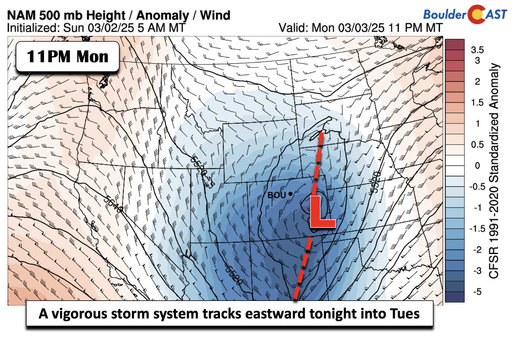
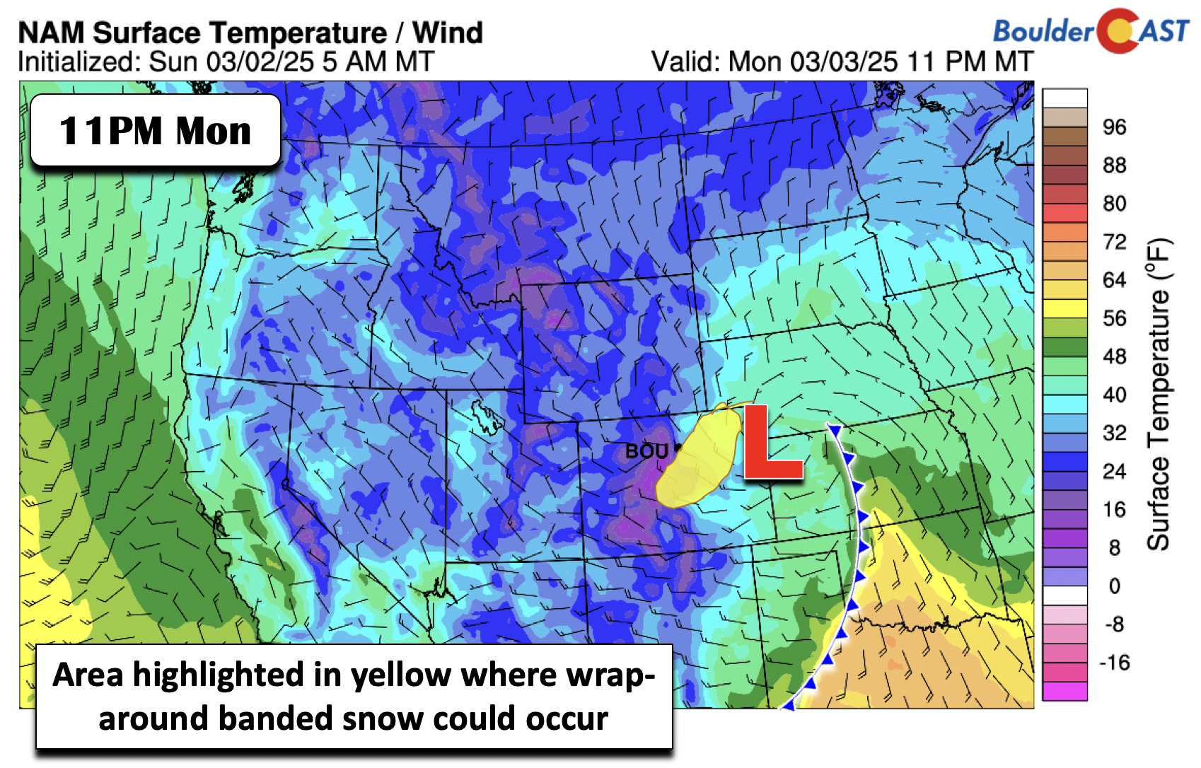
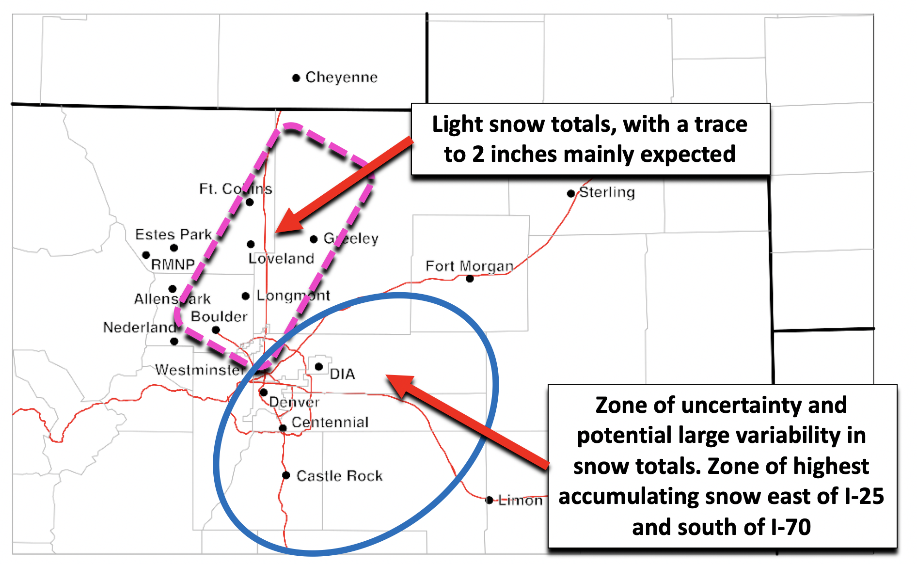
The vigorous mid-level trough will have a surface low tied to it, with the surface low pressure tracking into far east-central to northeast Colorado by late tonight and into early Tuesday. The track of the low is not particularly favorable for upslope-driven snowfall, but it may be overcome by an intense band of wrap-around snowfall on the northwest side of the system. This area is highlighted in yellow, which runs from southern sections of Denver into northeast Colorado.
The two images below depict two outcomes as to what could occur based on the surface low track and expected lift/energy. These two models are also in decent agreement on the pattern of snow amounts. They both show a limited amount of snow in Boulder to Ft. Collins and Greeley where temperatures will be too warm. The highest snow totals are expected along the Palmer Divide and areas eastward.
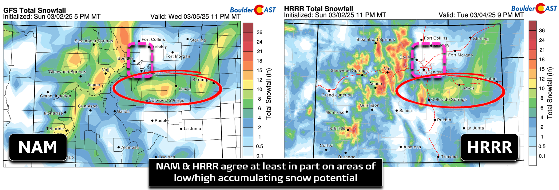
The reason for these differences in potential snow totals has to do with the forcing in place, and ultimately, the surface low track. Given the low track south and east of the Denver Metro, a more northerly to northwesterly wind will be in place north and west of I-70/I-76 and towards Boulder. These areas will be under predominant downslope flow, highlighted in pink below, with temperatures remaining too warm for snow initially. These regions are generally expected to see little or no snowfall (less than 1 inch). Initial rain and snow will develop Monday evening as the low passes and a brief period upslope combined with instability will bring showers to the area. Further to the south and east, mainly east of I-25 and south of I-70/I-76, is where wrap-around banded snow is forecast to develop. This region will be along and northwest of the northeastward tracking surface low. This region is highlighted in blue and also is zone of uncertainty, as where the deformation band sets up could set up +/- 50 miles from where the NAM/HRRR suggest it to be. As a result, confidence is not particularly high in where the totals will exactly be the highest. Nevertheless, in this blue area, snow totals could range from 1 to 4 inches, where isolated spots could exceed 6 inches given strong forcing for ascent on the northwest side of the system.
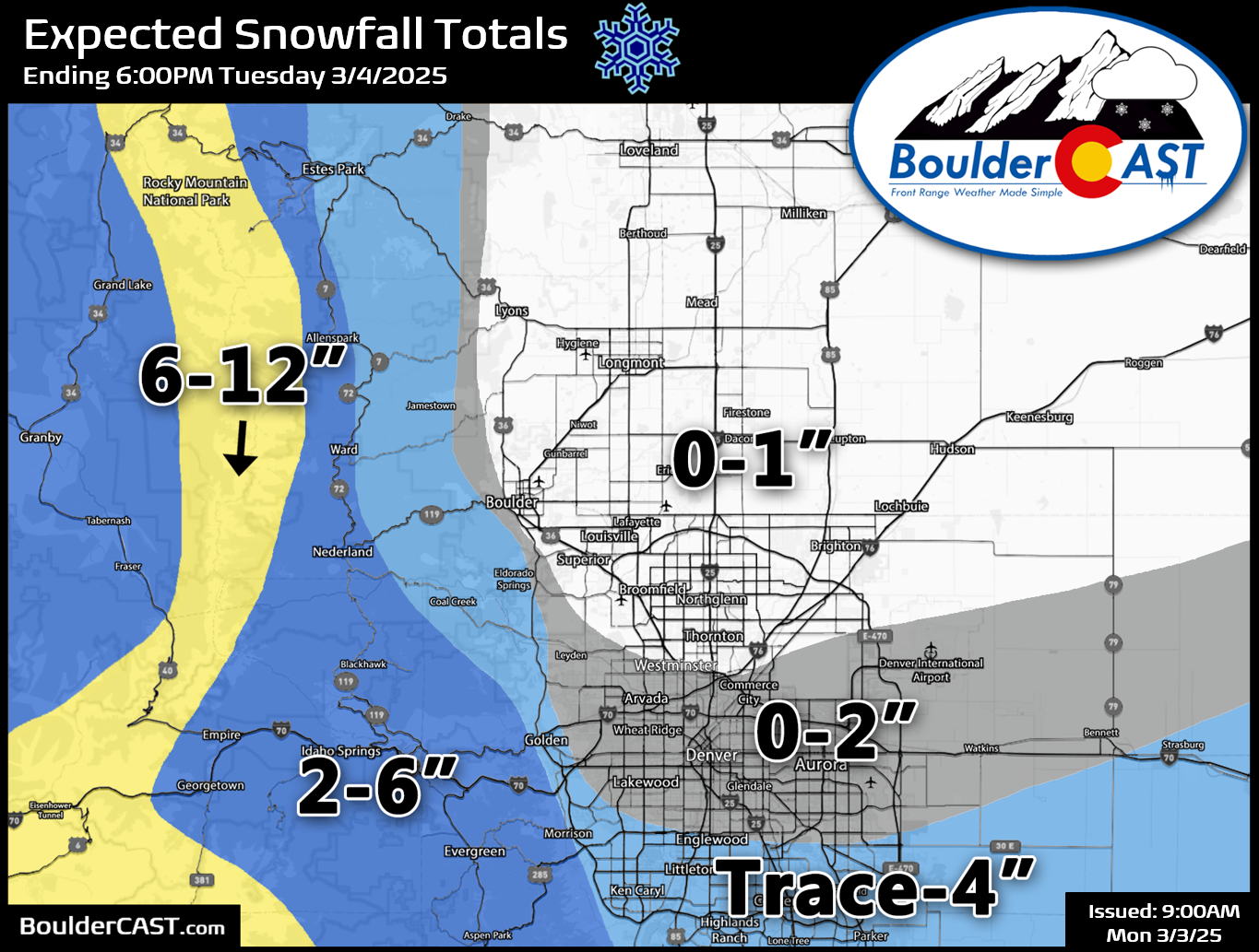
Our snowfall forecast map for snow falling late Monday into Tuesday is shown below. In general we’re mostly looking at very minor impacts for the Boulder-Denver area with just plain rain up to an inch or two of snow at best. The far southern Metro area and Foothills will see better chances for picking up a few inches of wet snow. The Mountains will be the big winner with this event, with 6-12″ of snow along the Continental Divide, including mountain passes.
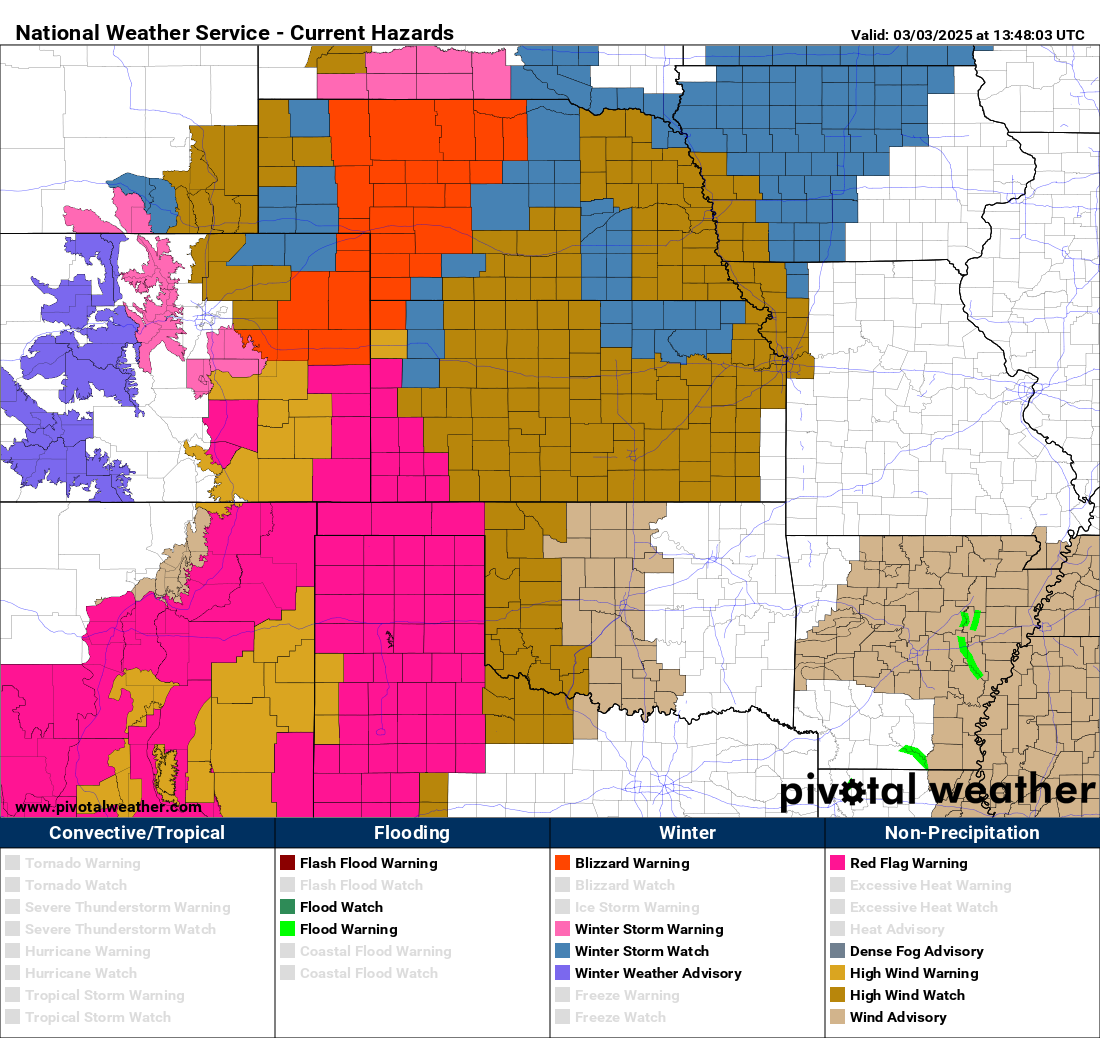
Winter Storm Warnings are posted for the Mountains and Palmer Divide, with Blizzard Warnings issued to the east along I-70 on the Plains towards Kansas! Plan on very difficult travel in these locations beginning this afternoon (Mountains) and this evening (Palmer Divide and east of Denver). This is big ol’ messy storm indeed with fire, wind and snowy impacts stretching across a broad area!
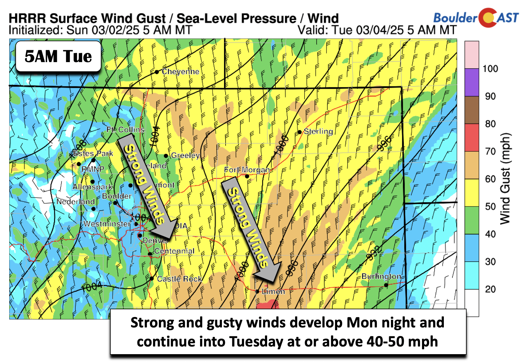
As you see above, another story with this storm system will be the winds — as the system moves east Monday night and into Kansas on Tuesday, strong winds will develop on the western fringe of the trough.
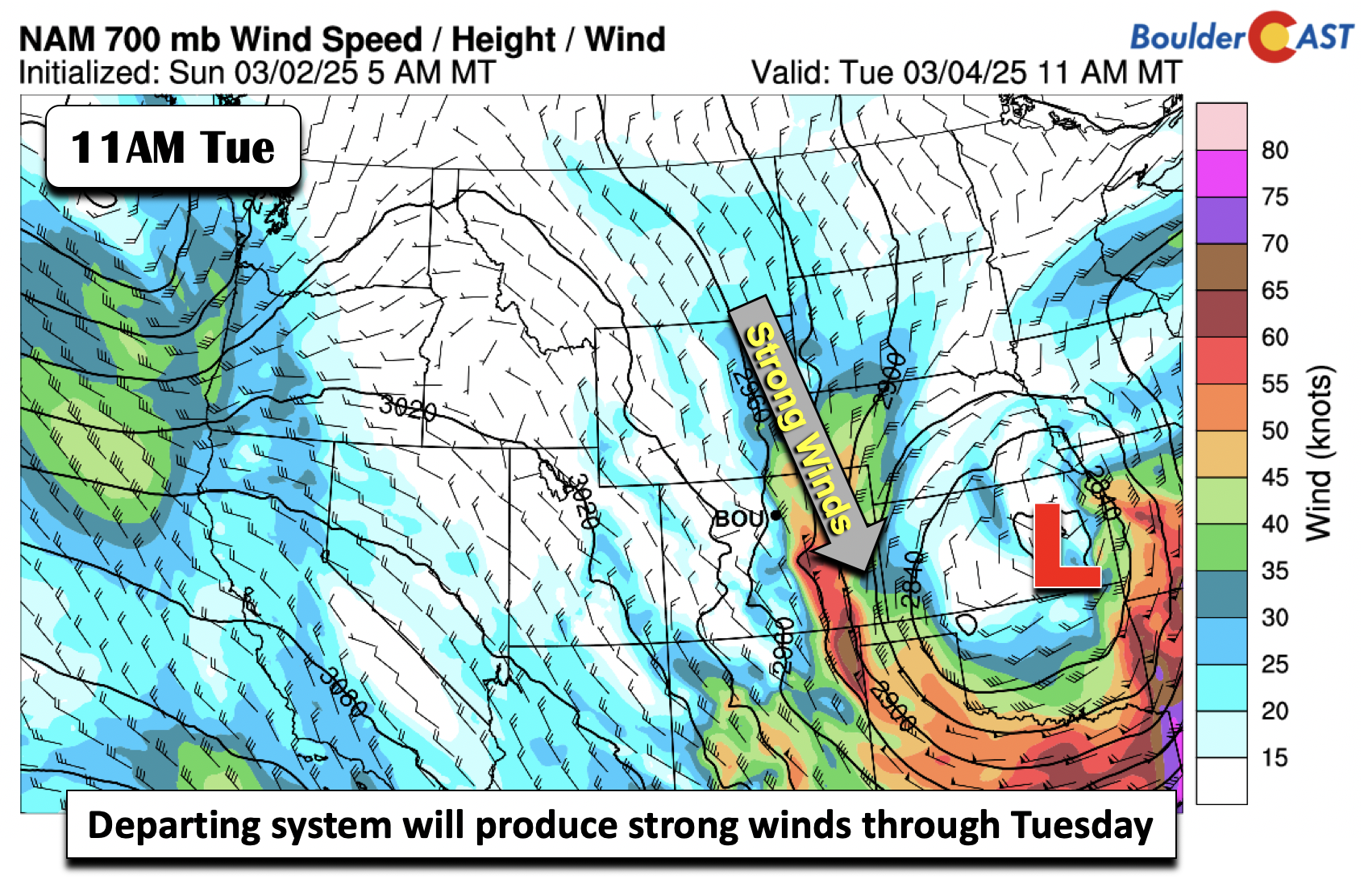
These gusts will be felt late Monday night and through Tuesday, at times exceeding 50 MPH in the eastern sections of the Denver Metro area. Lesser gusts are expected toward the Foothills in Boulder, roughly in the 20 to 40 MPH range.
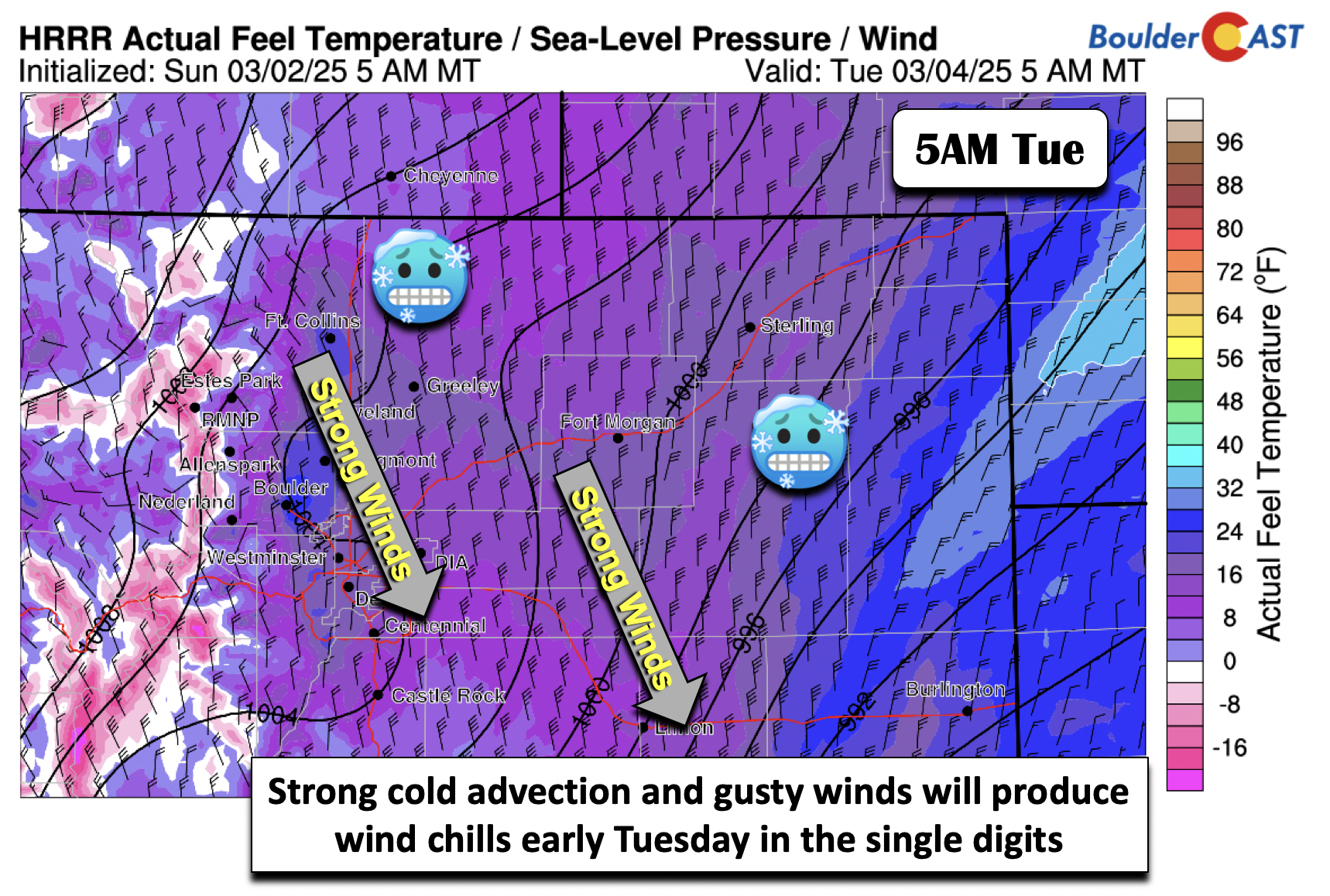
While we will see highs in the lower 60s Monday, colder air filters in tonight as the storm moves through and precipitation develops. Combined with this cold air and gustiness, wind chills will plummet into the teens and single digits by Tuesday morning, making for quite the change compared to this past weekend.
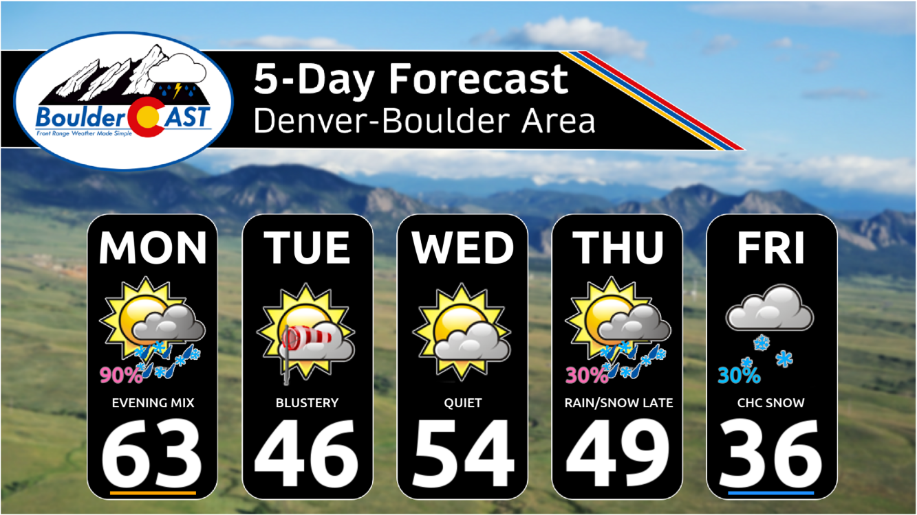
Here is a timeline for the rain/snow storm late Monday into Tuesday:
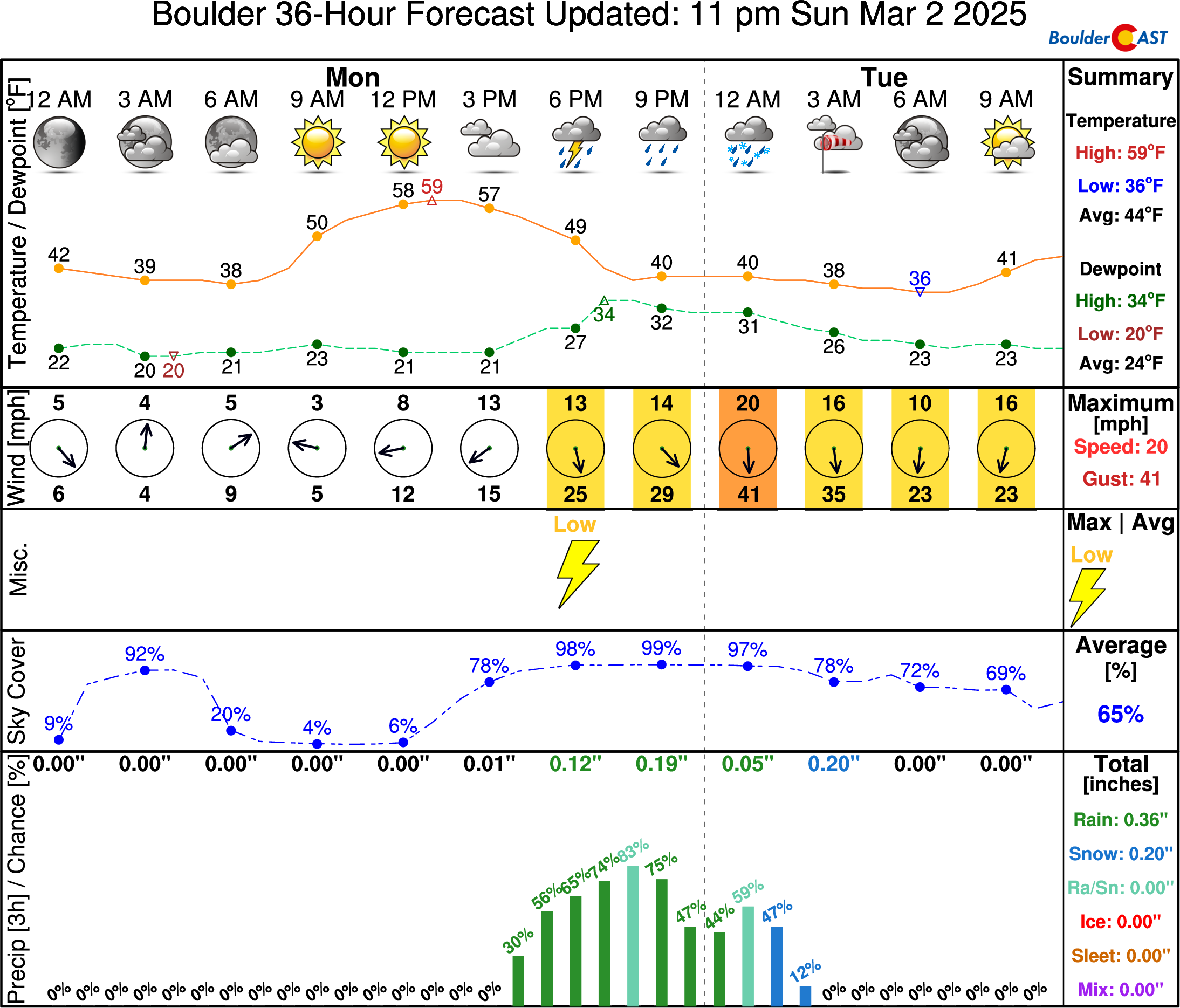
- Highs very mild for one last day on Monday in the lower 60s with early day sunshine
- Increasing clouds through the day Monday, turning gusty by evening
- Precipitation develops Monday late afternoon becoming widespread through the evening, focusing mostly east of I-25 and south of I-70/I-76 late tonight into the early overnight period. A few rumbles of thunder are possible during the first few hours. Precipitation will be mostly rain or light accumulating snow in Boulder-Denver, but heavier snow is expected in the Foothills and across the Palmer Divide areas with deteriorating travel. Blizzard conditions across the Plains of far eastern Colorado Monday night.
- Strong winds up to 50 MPH Monday night, with wind chills in the single digits and teens. Strong and gusty winds continue Tuesday in the 25 to 40 MPH range, mainly along/east of I-25.
- Colder on Tuesday in the 40s for highs
Quieter and warmer weather takes hold midweek under ridging building in aloft. Highs in the 50s for Wednesday.
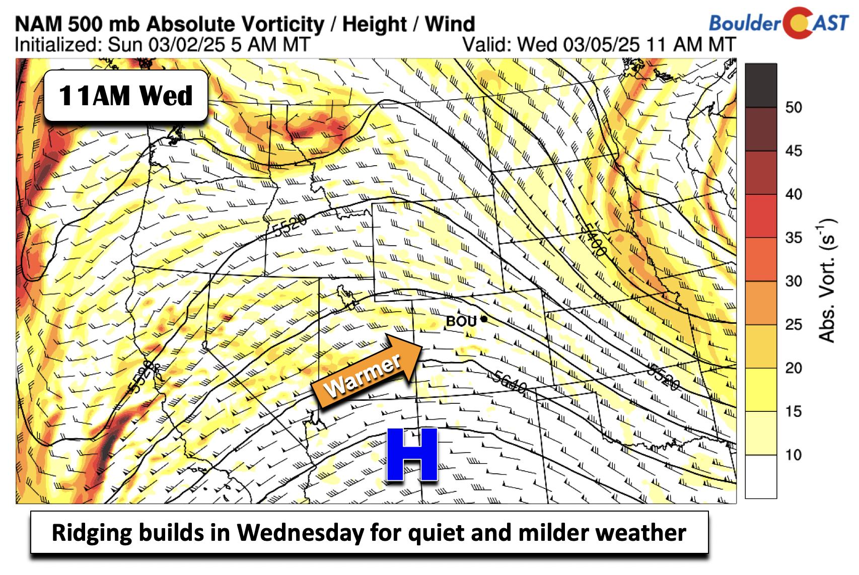
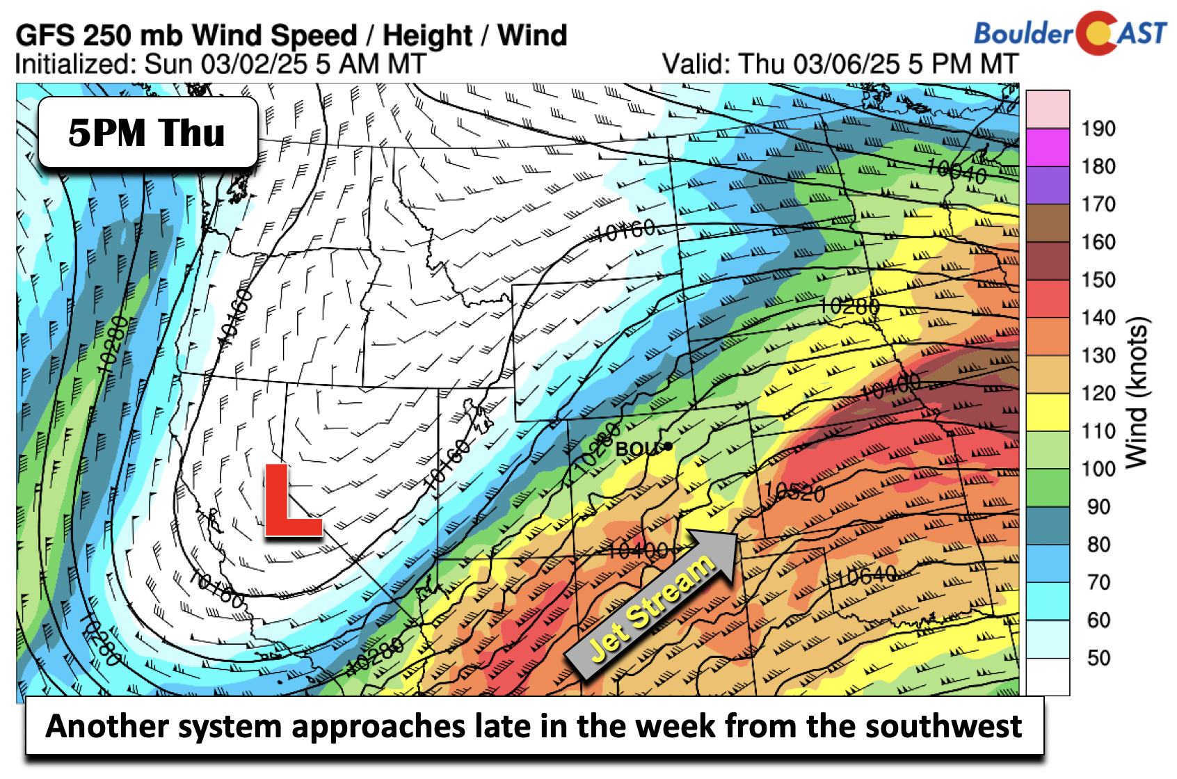
Ensemble data points to another snow chance for us late Thursday and Friday across the Front Range:
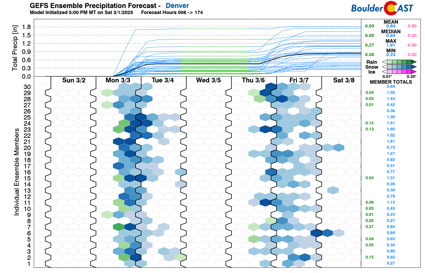
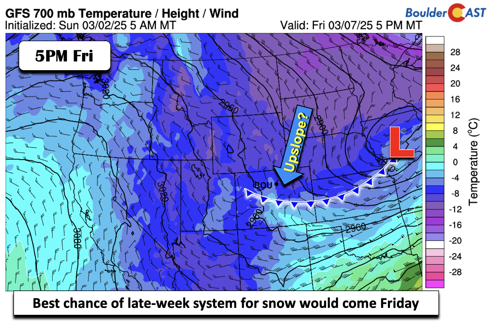
This late-week precipitation chances is tied to a southern-track system that will be at play later this week, approaching from the West Coast.
Based on the synoptic fields from the models, the best chance of any snow would occur late Thursday night or Friday in the wake of the mid-level low, where upslope and colder air filter in to produce light snow. Nothing looks particularly concerning as it stands now, but we’ll provide more details as we get closer! Nevertheless, it will turn colder by week’s end, back in the 30s to near 40 degrees for highs to end the week.
Enjoy the more active and seasonal weather this week! The 60s will return soon enough…
Forecast Specifics:
Monday: Increasing clouds by afternoon, then rain and snow developing during the late afternoon into evening, heaviest southeast of Denver and in the Foothills. Highs in the low 60s, then turning colder into the low 30s overnight with even colder wind chills. Wind gusts along/east of I-25 may gust over 50 MPH.
Tuesday: Much colder, blustery, and turning sunny, with 40s on the Plains and middle 30s in the Foothills. Gusts generally in the 20 to 35 MPH range through the day.
Wednesday: Quiet with warmer temperatures. Highs in the lower 50s on the Plains and upper 30s in the Foothills.
Thursday: Partly cloudy, then becoming mostly cloudy. A chance of late-evening rain/snow showers. Highs in the low 50s on the Plains and low 40s in the Foothills.
Friday: Colder with a chance of light snow. Highs in the mid/upper 30s in the Denver Metro to upper 20s in the Foothills.
Weekend: Drier and trending much warmer in the 50s to 60s again. Hooray!
Get BoulderCAST updates delivered to your inbox:
DISCLAIMER: This weekly outlook forecast is created Monday morning and covers the entire upcoming week. Accuracy will decrease as the week progresses as this post is NOT updated. To receive daily updated forecasts from our team, among many other perks, subscribe to BoulderCAST Premium.
Go Premium, get all the perks.
Daily Forecast Updates
Get our daily forecast discussion every morning delivered to your inbox.
All Our Model Data
Access to all our Colorado-centric high-resolution weather model graphics. Seriously — every one!
Ski & Hiking Forecasts
6-day forecasts for all the Colorado ski resorts, plus more than 120 hiking trails, including every 14er.
Smoke Forecasts
Wildfire smoke concentration predictions up to 72 hours into the future.
Exclusive Content
Weekend outlooks every Thursday, bonus storm updates, historical data and much more!
No Advertisements
Enjoy ad-free viewing on the entire site.
Enjoy our content? Give it a share!


You must be logged in to post a comment.