This week in the Front Range will feature two scorchingly hot days sandwiched between chances for thunderstorms. For the most part, the severe risk looks to be low throughout the extended, but we will need to monitor things late in the week as a surge of subtropical moisture may support more numerous storms and torrential rainfall rates. Read on for all the details.
This week’s highlights include:
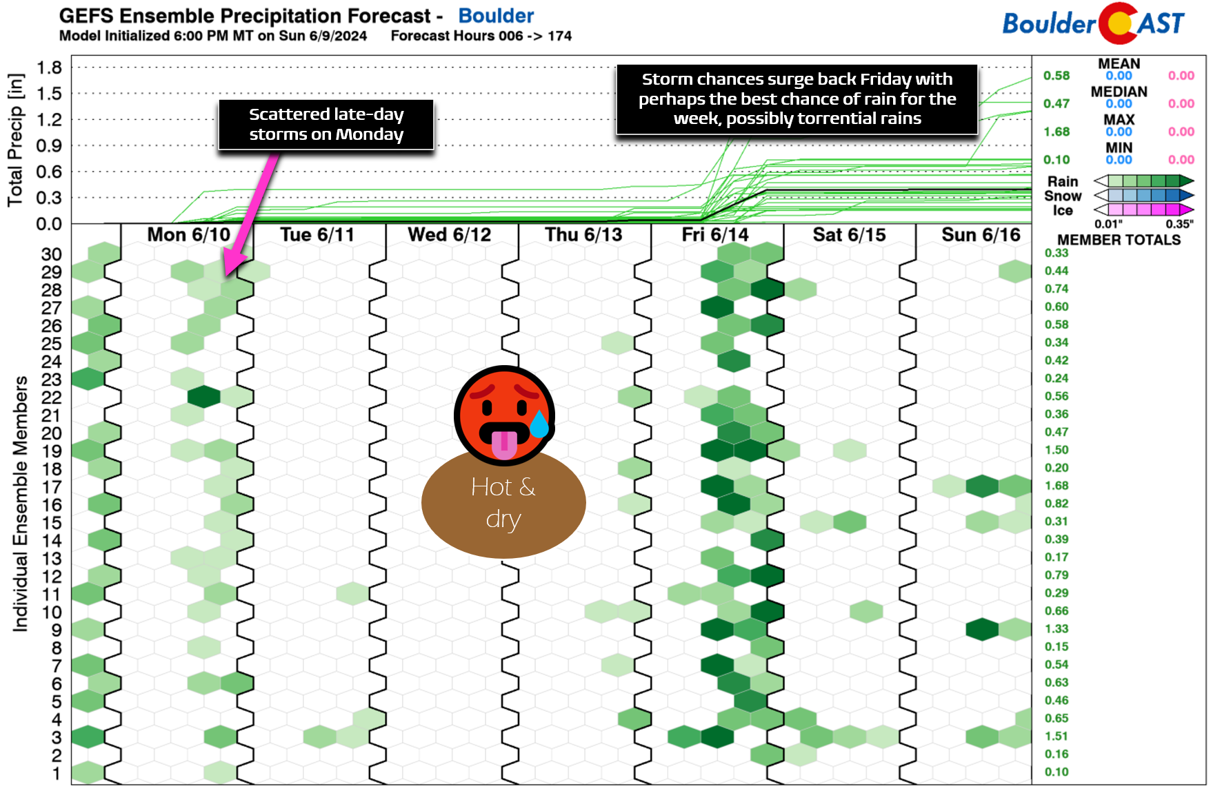
- Storm Chance on Monday: Scattered late-day thunderstorms return on Monday with a marginal risk for severe weather including hail and gusty winds
- Here Comes the Heat: Expect two very hot days midweek with temperatures potentially reaching the upper 90s in some areas
- Cooler & Rainy End to the Week: Friday could bring scattered to numerous thunderstorms, possibly with heavy rainfall rates, and cooler temperatures back into the 80s
- Weekend Outlook: The weekend is likely to dry out and warm up again, with any remaining storms being isolated at best
DISCLAIMER: This weekly outlook forecast is created Monday morning and covers the entire upcoming week. Accuracy will decrease as the week progresses as this post is NOT updated. To receive daily updated forecasts from our team, among many other perks, subscribe to BoulderCAST Premium.

Go Premium, get all the perks.
Daily Forecast Updates
Get our daily forecast discussion every morning delivered to your inbox.
All Our Model Data
Access to all our Colorado-centric high-resolution weather model graphics. Seriously — every one!
Ski & Hiking Forecasts
6-day forecasts for all the Colorado ski resorts, plus more than 120 hiking trails, including every 14er.
Smoke Forecasts
Wildfire smoke concentration predictions up to 72 hours into the future.
Exclusive Content
Weekend outlooks every Thursday, bonus storm updates, historical data and much more!
No Advertisements
Enjoy ad-free viewing on the entire site.
Rain chances dwindle as the heat ramps up
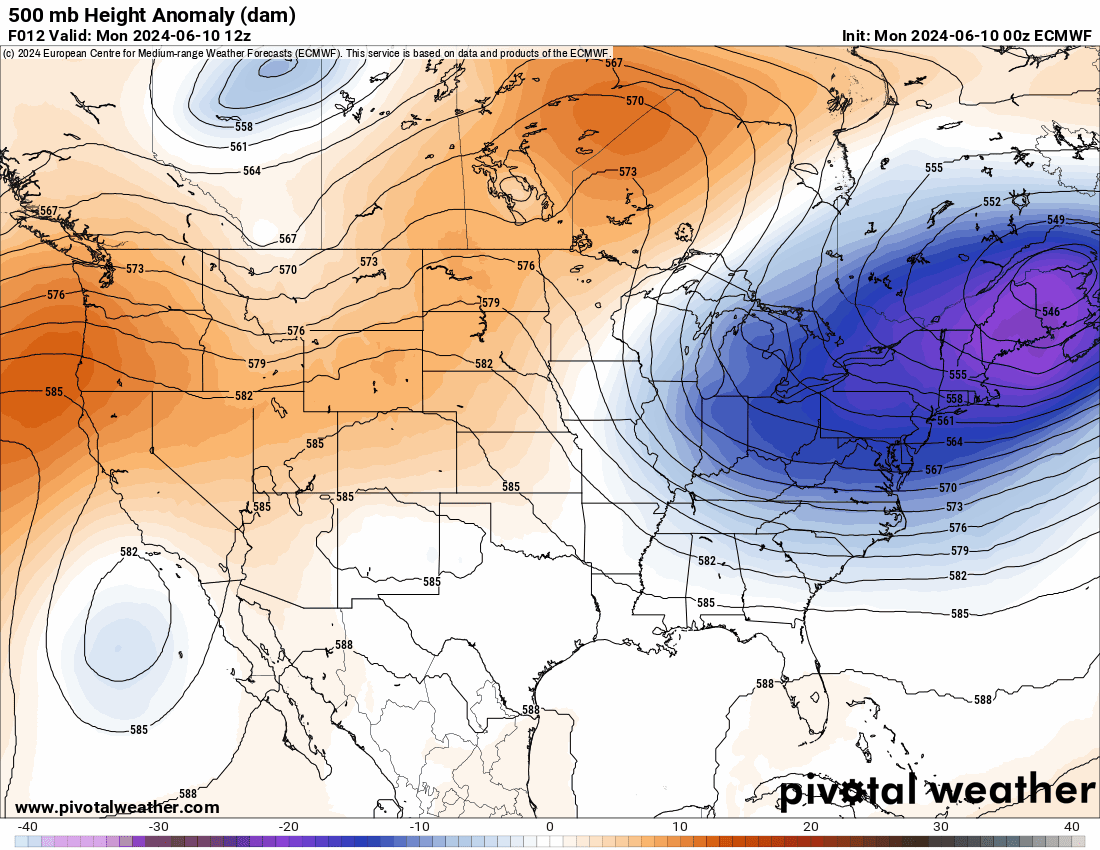
Similar to this past weekend, the risk of late-day thunderstorms will continue on Monday as yet another shortwave disturbance passes to our north across Montana and Wyoming, you know, up along where the primary storm track continues to reside across the West.
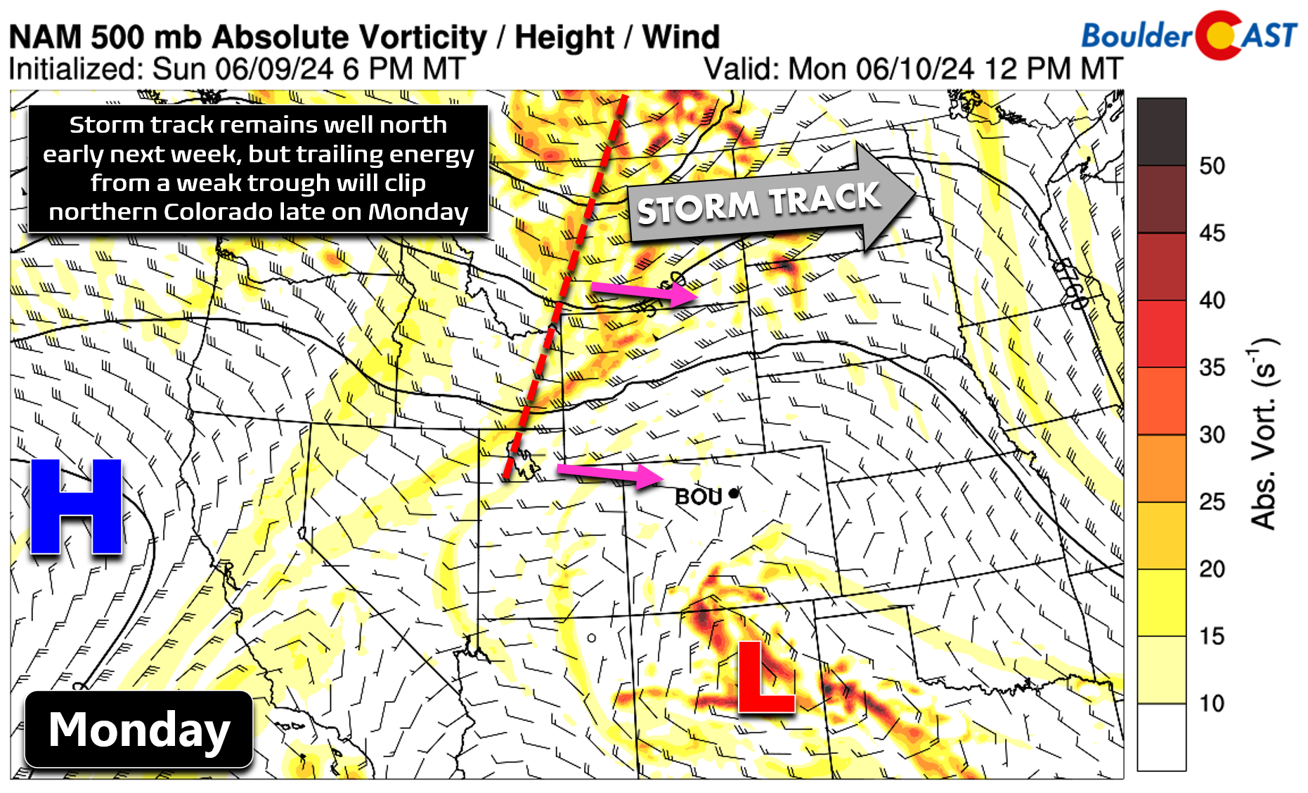
A bit of trailing energy associated with this shortwave will also clip northern Colorado on Monday, visible in the NAM 500mb vorticity animation below. The energy will arrive during the afternoon hours, timed nicely with peak solar heating, to force another round of late-day storms in the Metro area and northeast Colorado.
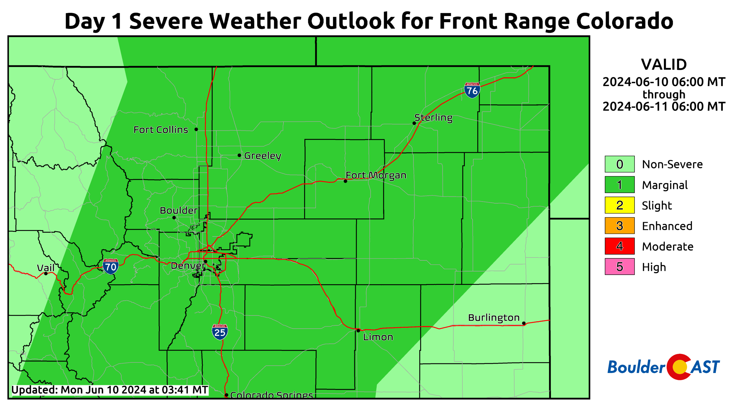
With weakly moderate shear lingering and ample moisture in place, a few storms on Monday might become strong to severe over the broader region. The Storm Prediction Center includes a rather large sector at Marginal Risk on Monday for severe weather, including the entirety of the Denver Metro and nearby terrain. Hail up to 1″ in diameter and 60 MPH wind gusts are the main concerns, but those occurrences should be few and far between.
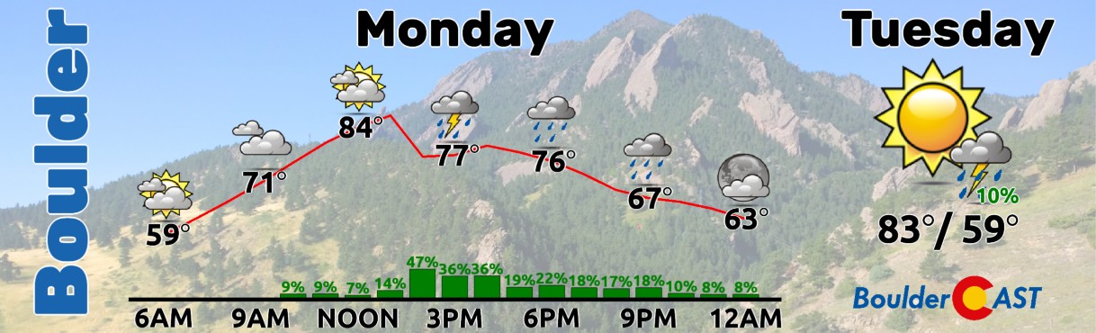
Look for the storm chances to begin around early to mid afternoon Monday and continue into the evening. There will be lots of high clouds around as well. High temperatures will reach the low to middle 80s before the storms roll in. In general, Monday’s storms could produce brief moderate rainfall, gusty winds and small hail.
With a lack of shortwave activity returning on Tuesday to help force thunderstorms, the broader ridge and warm air aloft over the area will begin to win out. Storm chances will nose-dive across the Metro, despite moisture still remaining anomalously high. However, a relatively flattened ridge will develop and hold over Colorado Tuesday and most of the week ahead. There could be a few isolated thunderstorms on Tuesday, mainly south of Denver, but most of us will turn dry with highs in the middle 80s.
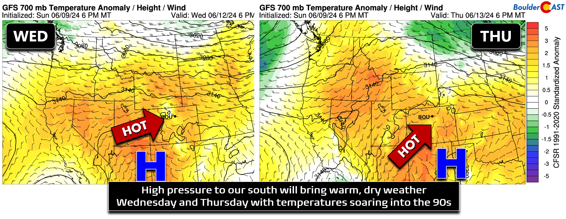
By Wednesday and Thursday, we will be strongly under the influence of the ridge with temperatures pushing well into the 90s and barely enough instability to form clouds let alone any precipitation. High temperatures both days will be in the middle 90s, with some upper 90s not out of the question on Thursday if the afternoon clouds don’t get too thick too early.
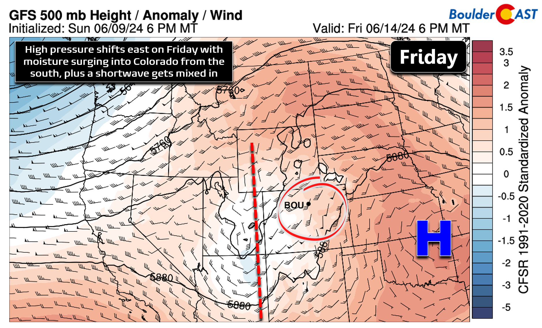
Friday will see the ridge shift off to the east with a decent fetch of southerly flow pouring into the Colorado — and yes that will mean a boost of moisture!
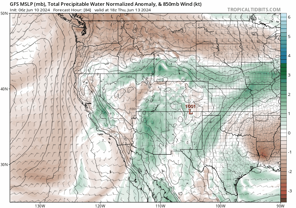
Early indication shows scattered to numerous showers and thunderstorms returning to the Front Range on Friday as a result of this surge in moisture from the south and an approaching shortwave from the Four Corners. In fact, Friday should offer our best chance of rain for the week, with heavy rainfall not out of the question.
Fortunately mid-level flow on Friday will be relatively strong from the south-southwest (see below) and thus the risk of flooding should be low. Friday’s rains will also cool us off back into the 80s for highs, a welcome reprieve after the toasty conditions days prior.
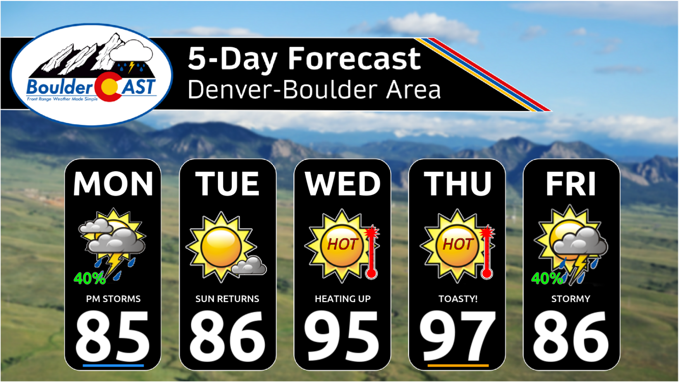
Here’s a look at the extended outlook — sandwiched in between the storms will be the hottest temperatures yet in 2024. Enjoy!
Get BoulderCAST updates delivered to your inbox:
Forecast Specifics:
Monday: Partly to mostly cloudy with scattered late-day thunderstorms. Some storms could be strong to severe with hail up to 1″ and 60 MPH wind gusts. Highs reach the middle 80s on the Plains with lower 70s in the Foothills.
Tuesday: Mostly sunny with only a few isolated storms developing south of Denver. The rest of the area will be dry. Highs stay seasonal in the middle 80s on the Plains with middle 70s in the Foothills.
Wednesday: Lots of sun early with a few late-day cloud developing. Hot with temperatures soaring into the middle 90s on the Plains with lower 80s in the Foothills.
Thursday: Similar to Wednesday but perhaps a degree or two hotter. Morning sunshine will give way to partly cloudy skies. High temperatures will bake into the middle to upper 90s on the Plains with middle 80s in the Foothills.
Friday: A mix of clouds and sun early, then scattered to numerous late-day thunderstorms, some of which could produce torrential rainfall. Temperatures will be cooler in the middle 80s on the Plains with lower 70s in the Foothills.
Weekend: Depending on the timing of the late-week shortwave/rains, the weekend will most likely dry out and warm back up into the 90s. Any storms that do linger should be isolated to widely scattered at best in the Metro area.
DISCLAIMER: This weekly outlook forecast is created Monday morning and covers the entire upcoming week. Accuracy will decrease as the week progresses as this post is NOT updated. To receive daily updated forecasts from our team, among many other perks, subscribe to BoulderCAST Premium.
Go Premium, get all the perks.
Daily Forecast Updates
Get our daily forecast discussion every morning delivered to your inbox.
All Our Model Data
Access to all our Colorado-centric high-resolution weather model graphics. Seriously — every one!
Ski & Hiking Forecasts
6-day forecasts for all the Colorado ski resorts, plus more than 120 hiking trails, including every 14er.
Smoke Forecasts
Wildfire smoke concentration predictions up to 72 hours into the future.
Exclusive Content
Weekend outlooks every Thursday, bonus storm updates, historical data and much more!
No Advertisements
Enjoy ad-free viewing on the entire site.
Enjoy our content? Give it a share!


You must be logged in to post a comment.