The week starts off with light snow and bitter cold Arctic air entrenched across the Front Range, but it won’t last long as the frigid airmass exits to our east quickly on Tuesday. While the rest of the week won’t exactly be warm, there will be a general upward trend in our temperatures back into the realm of normalcy. Our next chance of snow in the pipeline could arrive during the upcoming weekend. Read on for more details.
This week’s highlights include:
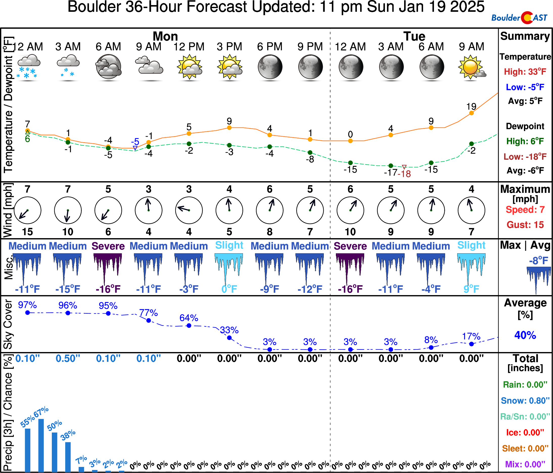
- Bitter Cold Monday: Monday brings bitter cold temperatures as Arctic air is well entrenched. We struggle to get out of the single digits and drop to below zero again Monday night. Any lingering light snow ends by midday Monday with little to no additional accumulation.
- Warm-Up: Temperatures will moderate much of the remainder of the week, but stay below normal overall. Our warmest days are likely to be Tuesday and parts of Friday.
- Colder Air Returns: Colder air is poised to return this weekend with another Arctic Front, though it currently does not appear as cold as the recent fronts.
- Weekend Snow Chance: Signs point to a return chance of snow sometime late Friday or this weekend
DISCLAIMER: This weekly outlook forecast is created Monday morning and covers the entire upcoming week. Accuracy will decrease as the week progresses as this post is NOT updated. To receive daily updated forecasts from our team, among many other perks, subscribe to BoulderCAST Premium.
Daily Forecast Updates
Get our daily forecast discussion every morning delivered to your inbox.
All Our Model Data
Access to all our Colorado-centric high-resolution weather model graphics. Seriously — every one!
Ski & Hiking Forecasts
6-day forecasts for all the Colorado ski resorts, plus more than 120 hiking trails, including every 14er.
Smoke Forecasts
Wildfire smoke concentration predictions up to 72 hours into the future.
Exclusive Content
Weekend outlooks every Thursday, bonus storm updates, historical data and much more!
No Advertisements
Enjoy ad-free viewing on the entire site.
Bitter cold Arctic air starts the week
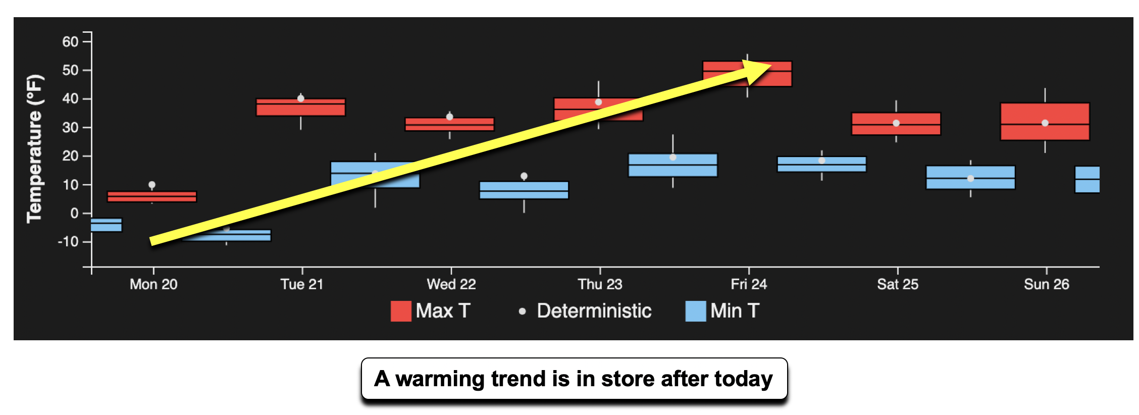
Afinal blast of frigid Arctic air will start our work week, but there is good news on the horizon — a warm-up is set to develop the remainder of the week! The forecast high and low temperatures are shown below from an ensemble system for Boulder/Denver. Note that while there are fluctuations in temperatures, the overall trend is upward through the week ahead.
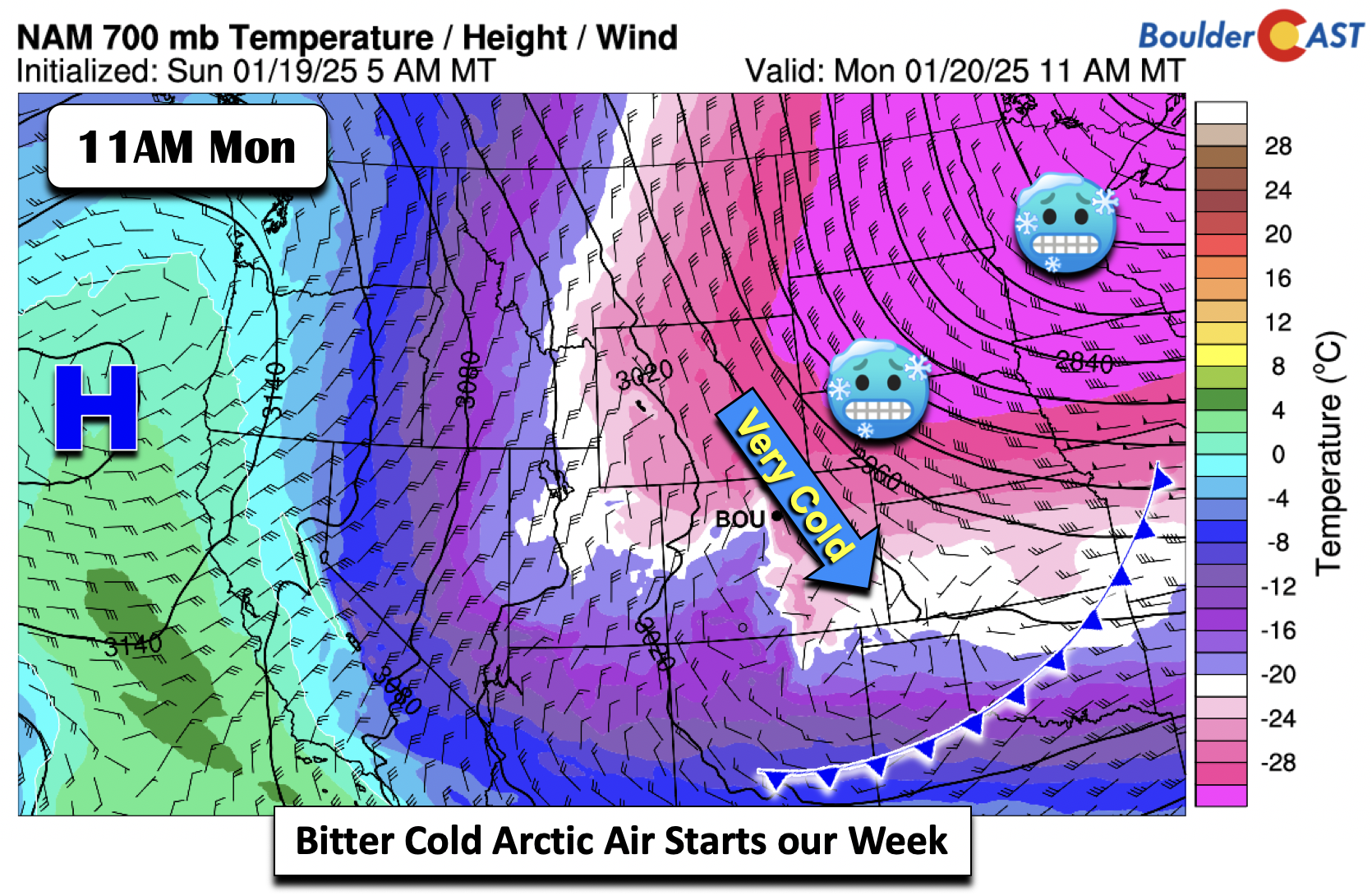
Before we move into warmer times, Monday will be our coldest day of the week as frigid Arctic air extends in from the Northern Great Plains and Upper Mississippi Valley.
Expect very cold highs on Monday, despite some sunshine later in the day. We’ll have a tough time getting out of the single digits! Very light snow lingering early Monday morning around Boulder will taper off by midday, leaving behind a fresh blanket of snow accompanying the Arctic air. A dusting or less of additional accumulation could occur Monday morning in the best upslope areas. For Monday night, the clear skies, light winds and new snow will allow lows to plummet below zero in most locales, at least briefly. As winds pick up overnight coming off the terrain, rising temperatures will develop as a new air mass begins to work in. This is shown below by NowCAST, with our coldest temperatures Monday night pegged for around midnight, with warming occurring thereafter.
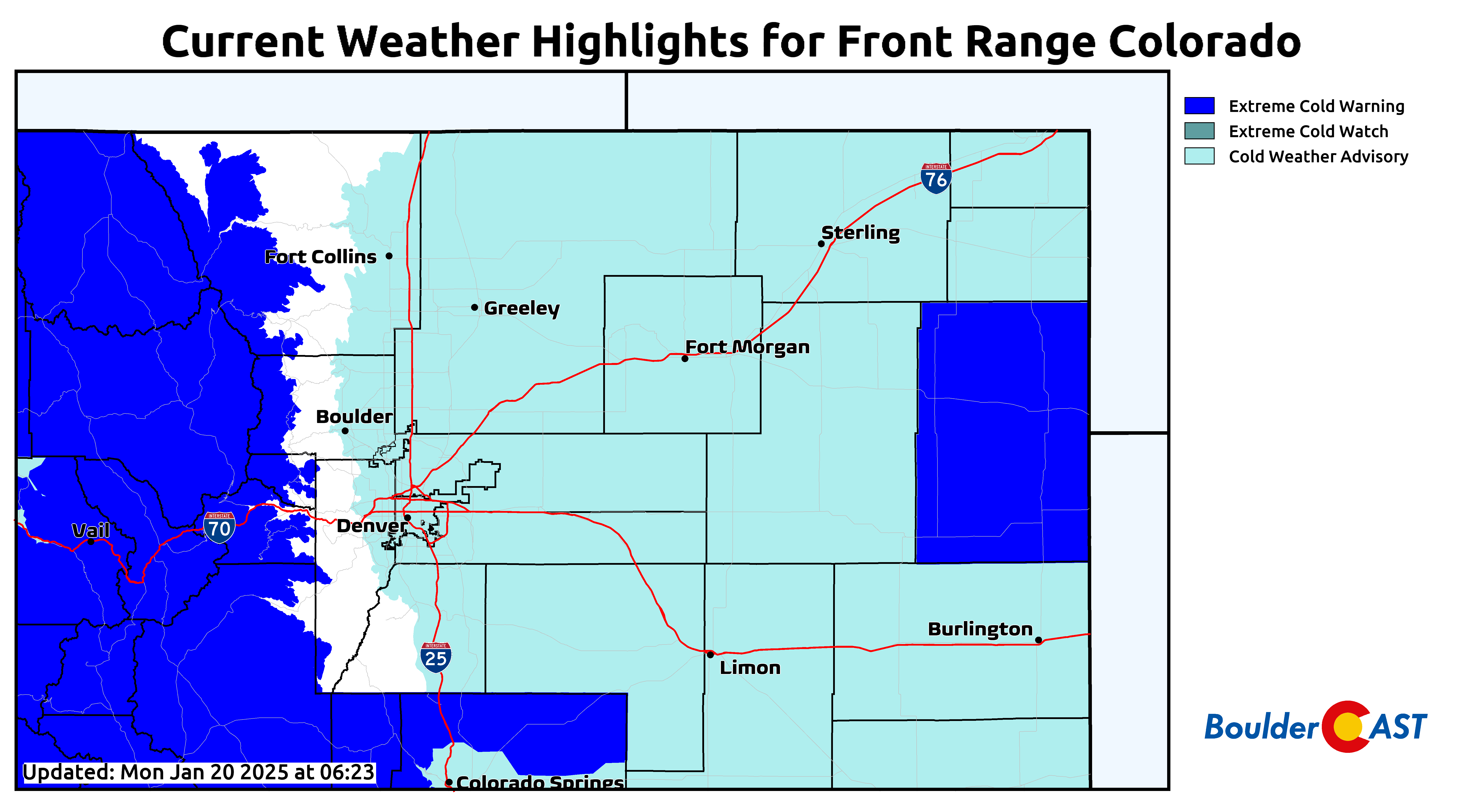
Don’t let your guard down just yet! Warmer weather is indeed on the way, but we’ve still got another 24 hours to go with dangerous wind chills ranging from 0 to -20°F across the Denver Metro area! Cold Weather Advisories remain in effect for the region through Tuesday morning.
Warmer the remainder of the week but staying below normal
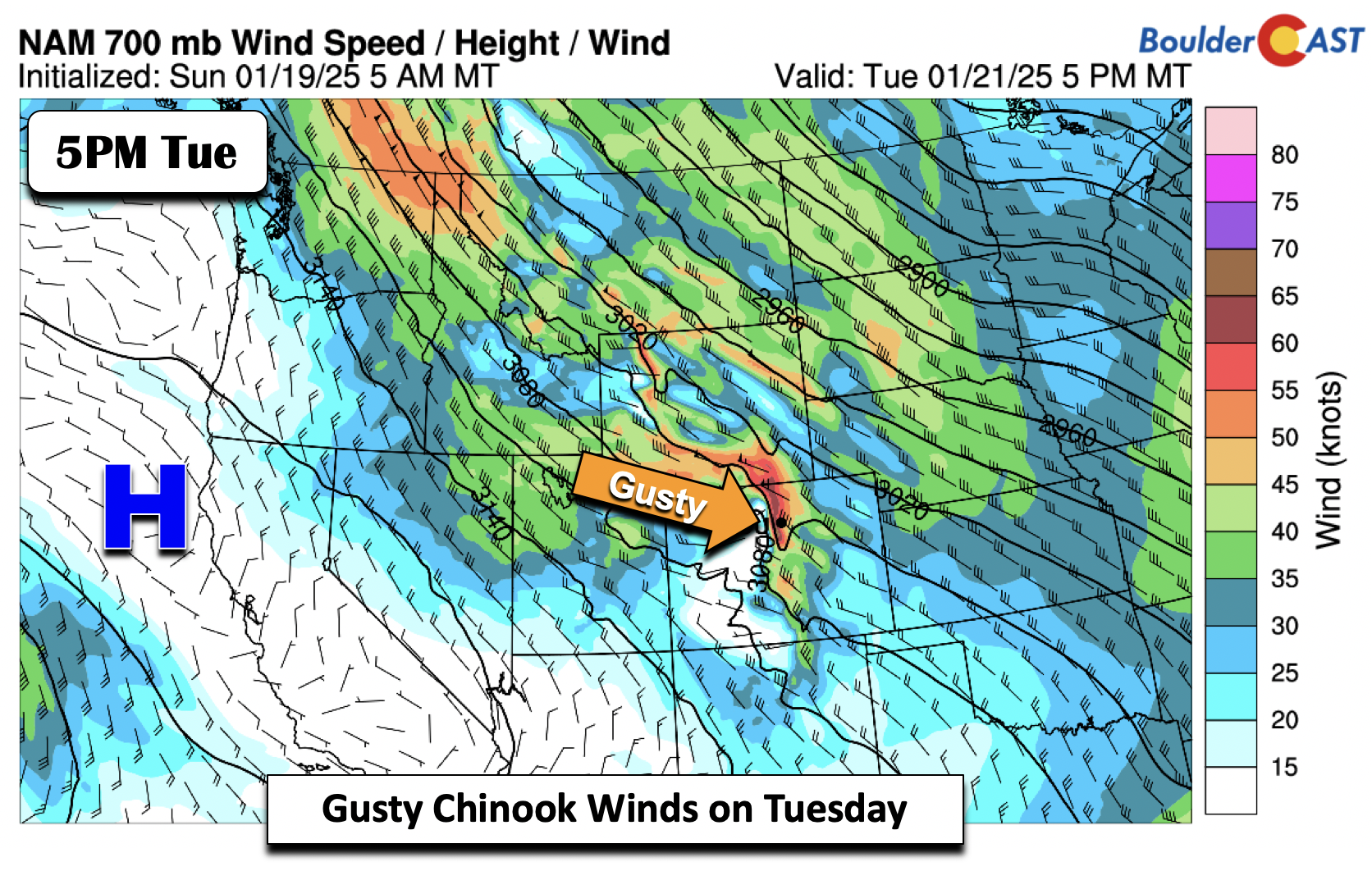
The remainder of the week ahead will be warmer, but stays below normal for the most part. Starting Tuesday, high pressure along the West Coast will aid in Chinook warming through downslope flow across the Metro area. This will help to the push the Arctic air toward the East Coast. Our Tuesday will still be some 10 degrees below normal, but our highs will be about 30 degrees warmer compared to Monday, reaching into the upper 30s by Tuesday afternoon.
A west-northwest wind crossing the mountains will bring about =gusty surface winds during the daytime Tuesday, gusting over 25 MPH at times.
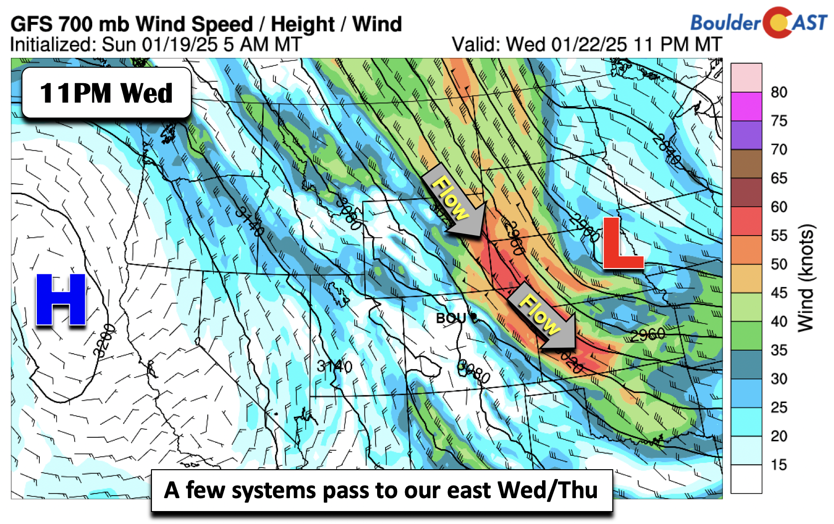
Between Wednesday and Thursday, the ridge along the West Coast will slide to the west just enough to allow for a northwest flow to persist across the state. Two areas of low pressure will take a northwest to southeast track, largely staying to our east. We can’t rule out a stray snow shower on Wednesday or Thursday, but for now the guidance has these systems staying far enough removed such that we stay dry. Nonetheless, they are close enough to give us some gusty northerly winds and persistent cold advection. This should keep our highs Wednesday and Thursday in the 30s, but still a far cry from the single digits of Monday.
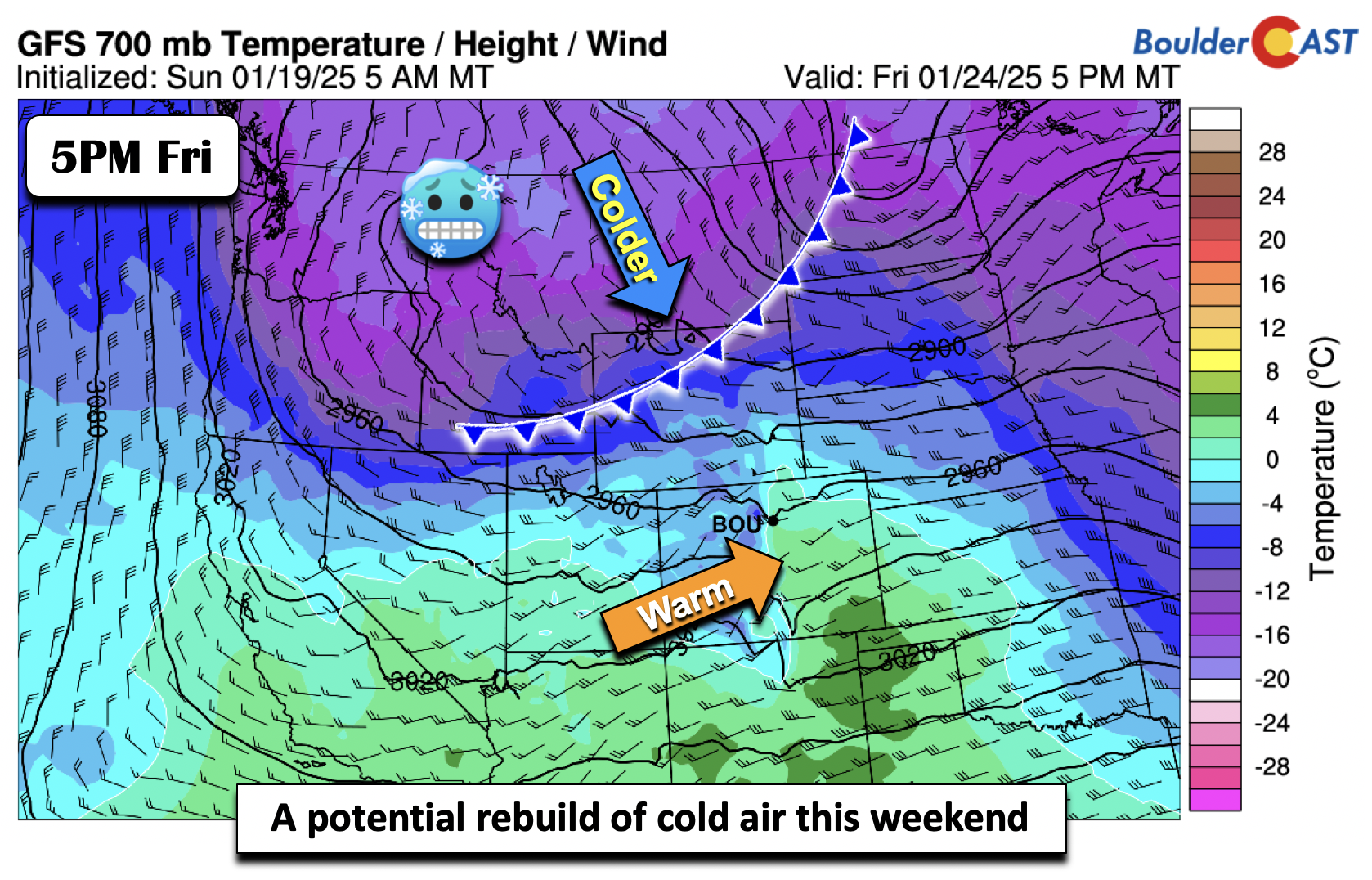
By late-week, most guidance shows another potential warmup, perhaps close to normal for once in the many days since the Arctic outbreak. The GFS shows colder air working south late Friday and especially Saturday, but most of our Friday afternoon at this point looks warm with a southwest flow in the low-levels. If the front on Friday is faster, then all bets are off. But as of now, we could be in the 40s to end the week!
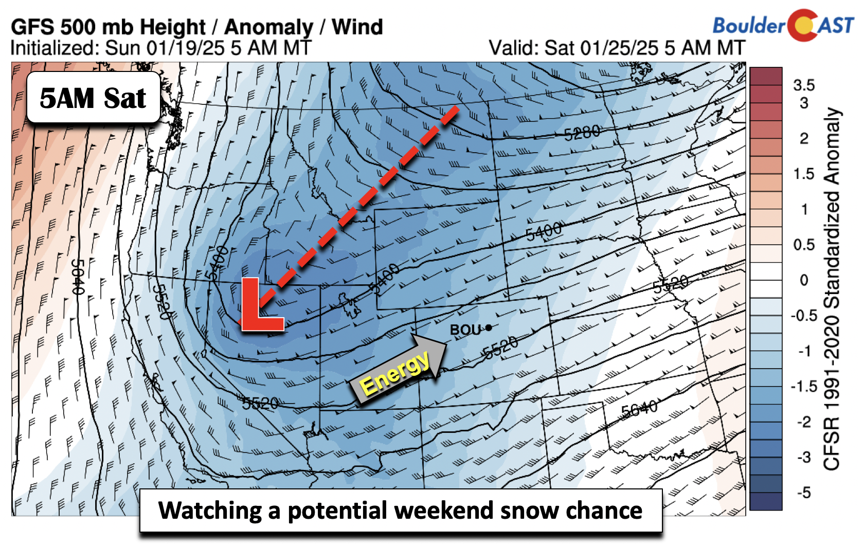
Speaking of that late-week cold front, it does appear a colder trend is in store, with high temperatures back to well below normal in the low 30s. What is more unclear is if a system can interact with the front and give us some snow. Right now, the models are mixed, but do show a potential mid-level system that could pump in moisture and lift to bring us our next snow chance. The timing of anything that develops would sometime Friday night or Saturday or Saturday into Sunday. We won’t mention potential amounts this far out as things are far too uncertain. Just know that we are already keeping a close eye on our next chance of snow for the upcoming weekend!
Enjoy the chilly start to the week and the path towards warmer temperatures!
Forecast Specifics:
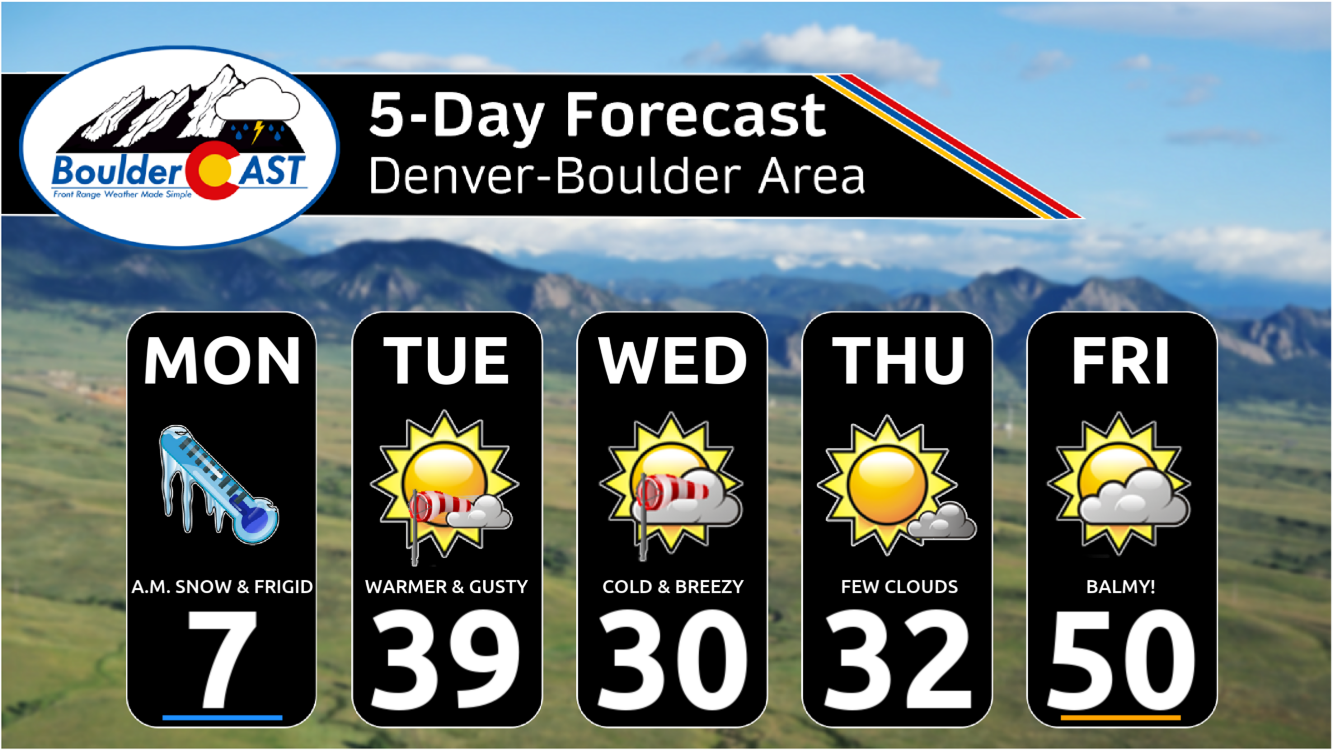
Monday: Light snow ending early, then becoming partly sunny. Additional accumulations during the morning of a light dusting or less. Bitter cold with highs in the single digits on the Plains and Foothills. Overnight lows tonight drop slightly below zero, but warming through the night in many areas, especially in Boulder.
Tuesday: Mostly sunny and breezy, but warmer, with upper 30s on the Plains and low 30s in the Foothills. Winds may gust over 25 MPH at times.
Wednesday: Partly sunny, breezy and chilly with lower 30s on the Plains and middle 20s in the Foothills. Breezes of 10 to 25 MPH common.
Thursday: Partly to mostly sunny and chilly with low to middle 30s for the Plains and upper 20s in the Foothills.
Friday: A balmy day with high temperatures near 50 degrees on the Plains and upper 30s in the Foothills.
Weekend: A return to cold weather for Saturday and Sunday with temperatures back around the freezing mark across the Metro area. There is also a chance of snow for the early part of the weekend Friday night or Saturday.
Get BoulderCAST updates delivered to your inbox:
DISCLAIMER: This weekly outlook forecast is created Monday morning and covers the entire upcoming week. Accuracy will decrease as the week progresses as this post is NOT updated. To receive daily updated forecasts from our team, among many other perks, subscribe to BoulderCAST Premium.
Daily Forecast Updates
Get our daily forecast discussion every morning delivered to your inbox.
All Our Model Data
Access to all our Colorado-centric high-resolution weather model graphics. Seriously — every one!
Ski & Hiking Forecasts
6-day forecasts for all the Colorado ski resorts, plus more than 120 hiking trails, including every 14er.
Smoke Forecasts
Wildfire smoke concentration predictions up to 72 hours into the future.
Exclusive Content
Weekend outlooks every Thursday, bonus storm updates, historical data and much more!
No Advertisements
Enjoy ad-free viewing on the entire site.
Enjoy our content? Give it a share!





You must be logged in to post a comment.