While Punxsutawney Phil and Flatiron Freddy both saw their shadows Sunday morning solidifying their predictions for six more weeks of winter, we’ll start off February with wildly above normal temperatures in the 60s to lower 70s here in the Front Range. However, we are watching an Arctic cold front that will peskily waver back and forth across northeast Colorado as the week progresses leading to fluctuating temperatures and plenty of uncertainty. The brunt of the cold air, though, likely will not plunge into our area until sometime next week alongside increasing chances for snowflakes.
This week’s highlights include:
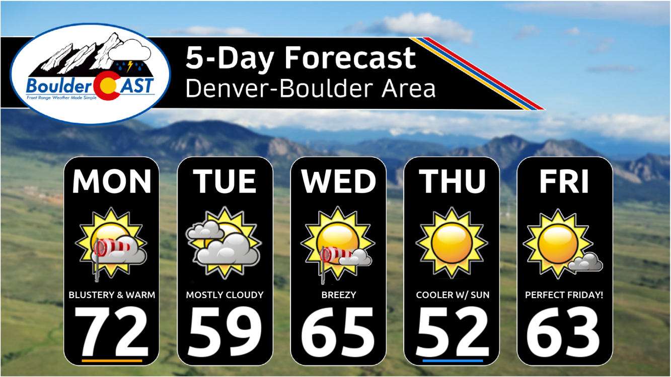
- Very Warm Early Week: The first full week of February starts off well above average with high temperatures in the 60s and lower 70s — some days even approaching record highs
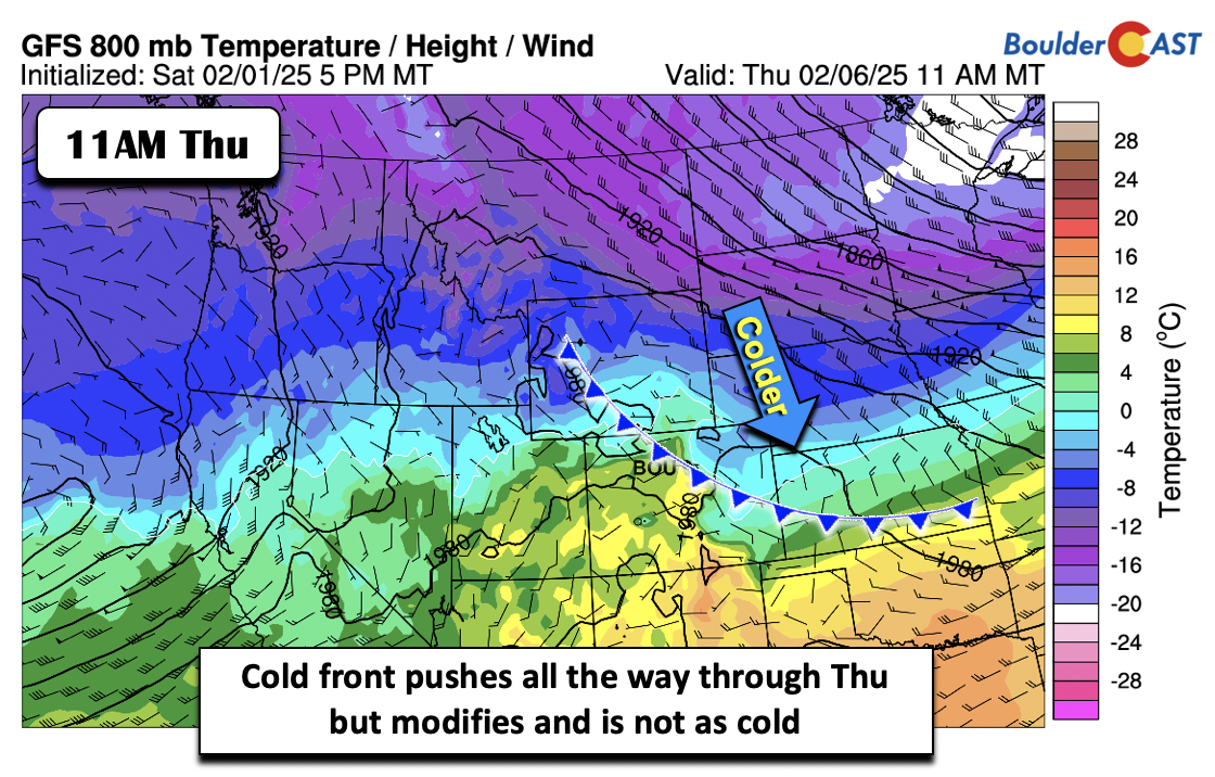
- Turning Cooler: An Arctic front will waver back and forth across northeast Colorado this week, pushing fully through most of our region by Thursday or so but in a muted state. This will favor up and down temperatures through the week, but nothing too drastic.
- Light Mountain Snow: A series of mid-level systems will move through the state Wednesday in to Saturday, producing light snow in the Mountains and some lower elevation wind.
- Active and Colder in the Extended: Guidance favors a colder airmass moving in sometime next week along with a more active storm track. Snow chances will increase for the second week of February.
DISCLAIMER: This weekly outlook forecast is created Monday morning and covers the entire upcoming week. Accuracy will decrease as the week progresses as this post is NOT updated. To receive daily updated forecasts from our team, among many other perks, subscribe to BoulderCAST Premium.

Go Premium, get all the perks.
Daily Forecast Updates
Get our daily forecast discussion every morning delivered to your inbox.
All Our Model Data
Access to all our Colorado-centric high-resolution weather model graphics. Seriously — every one!
Ski & Hiking Forecasts
6-day forecasts for all the Colorado ski resorts, plus more than 120 hiking trails, including every 14er.
Smoke Forecasts
Wildfire smoke concentration predictions up to 72 hours into the future.
Exclusive Content
Weekend outlooks every Thursday, bonus storm updates, historical data and much more!
No Advertisements
Enjoy ad-free viewing on the entire site.
A Very Warm Start
Boulder’s own stuffed marmot, Flatiron Freddy, saw their shadow Sunday morning, finalizing their prediction for six more weeks of winter in eastern Colorado. Similarly, the official Groundhog Day prediction was made some 1500 miles to the east on Sunday, when Punxsutawney Phil in Pennsylvania had the very same wintry revelation after also seeing their shadow.
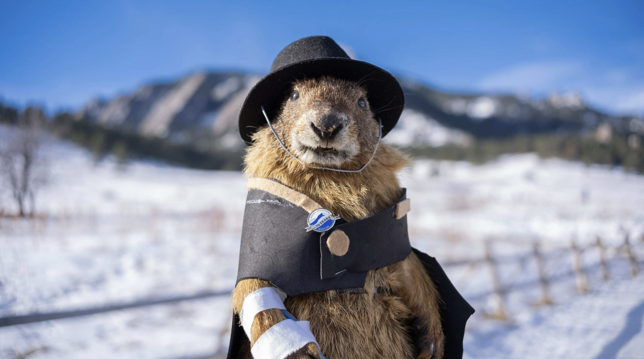
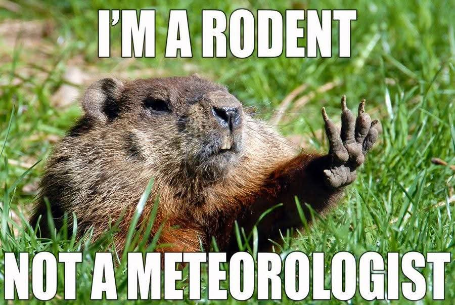
Despite these projections, the Front Range will kick off the month of February with spring-like temperatures, perhaps once again bringing into question the meteorological credentials of the famous rodents!
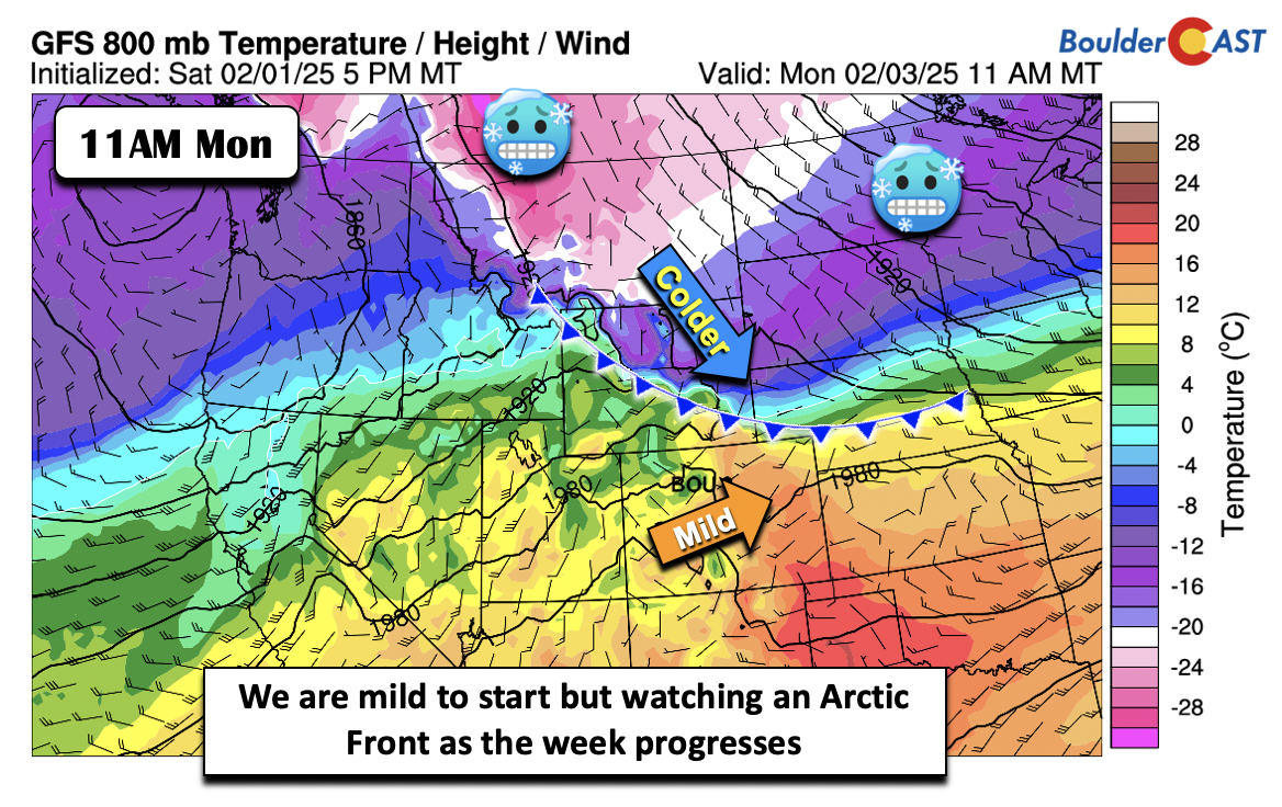
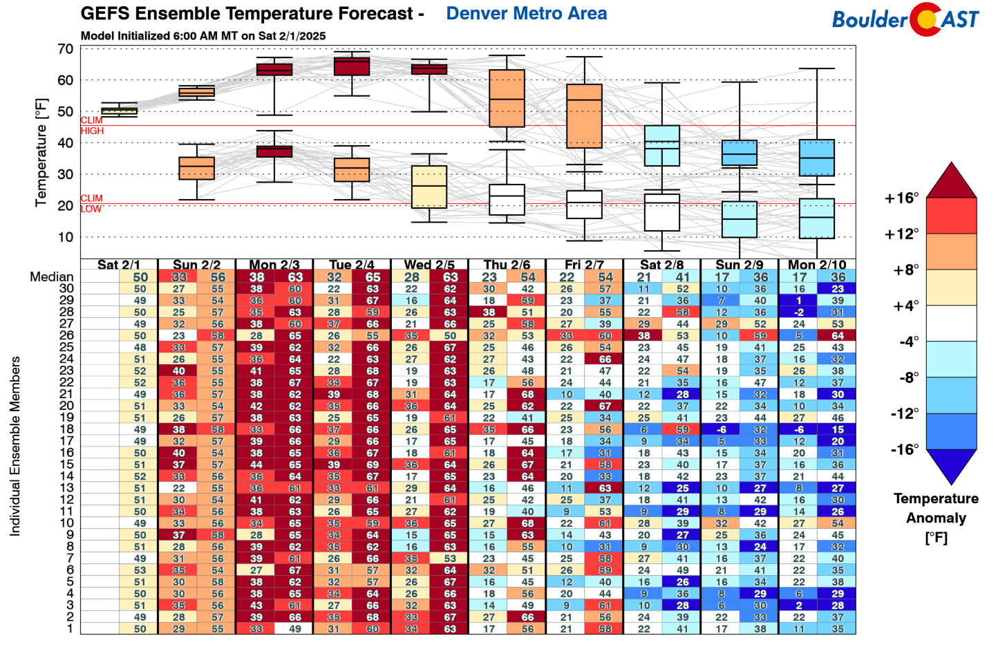
All jokes aside, below shows the larger-scale weather pattern to start this week across the West. It features broad low pressure over the Pacific Northwest, while ridging stretches from the Desert Southwest, across Colorado and into the southern Plains. You are going to love the start of the week with near-record high temperatures in the Denver Metro area early Monday afternoon, with most of us set to see lower 70s. The gusty winds from Sunday and Sunday night will relax somewhat through the day Monday leading to less wind impacts. This trough-ridge pattern is expected to prevail through most of the week across the West, but there will be a cold front nearby at all times leading to some uncertainty in our exact temperatures.
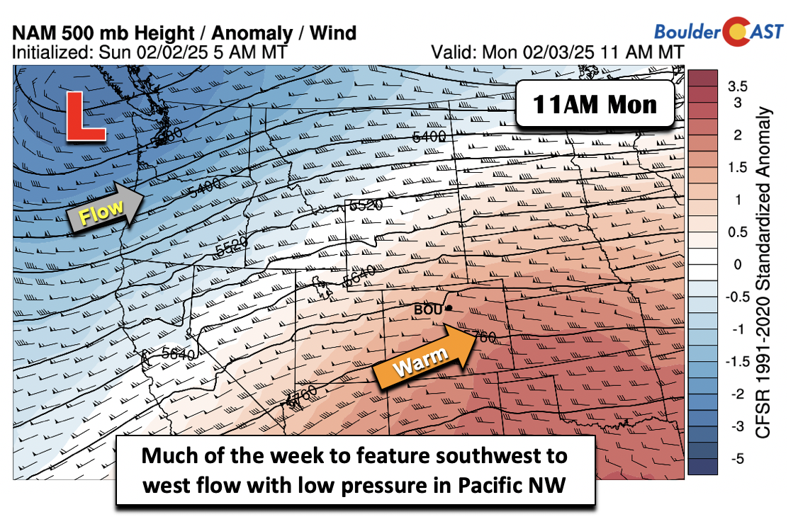
As of Monday morning, an Arctic front is located northeast of our area across Wyoming and west Nebraska. Temperatures ahead of the front within the warm downslope are around 60 degrees in the Boulder-Denver area, but behind the front temperatures are below zero in northern Wyoming.
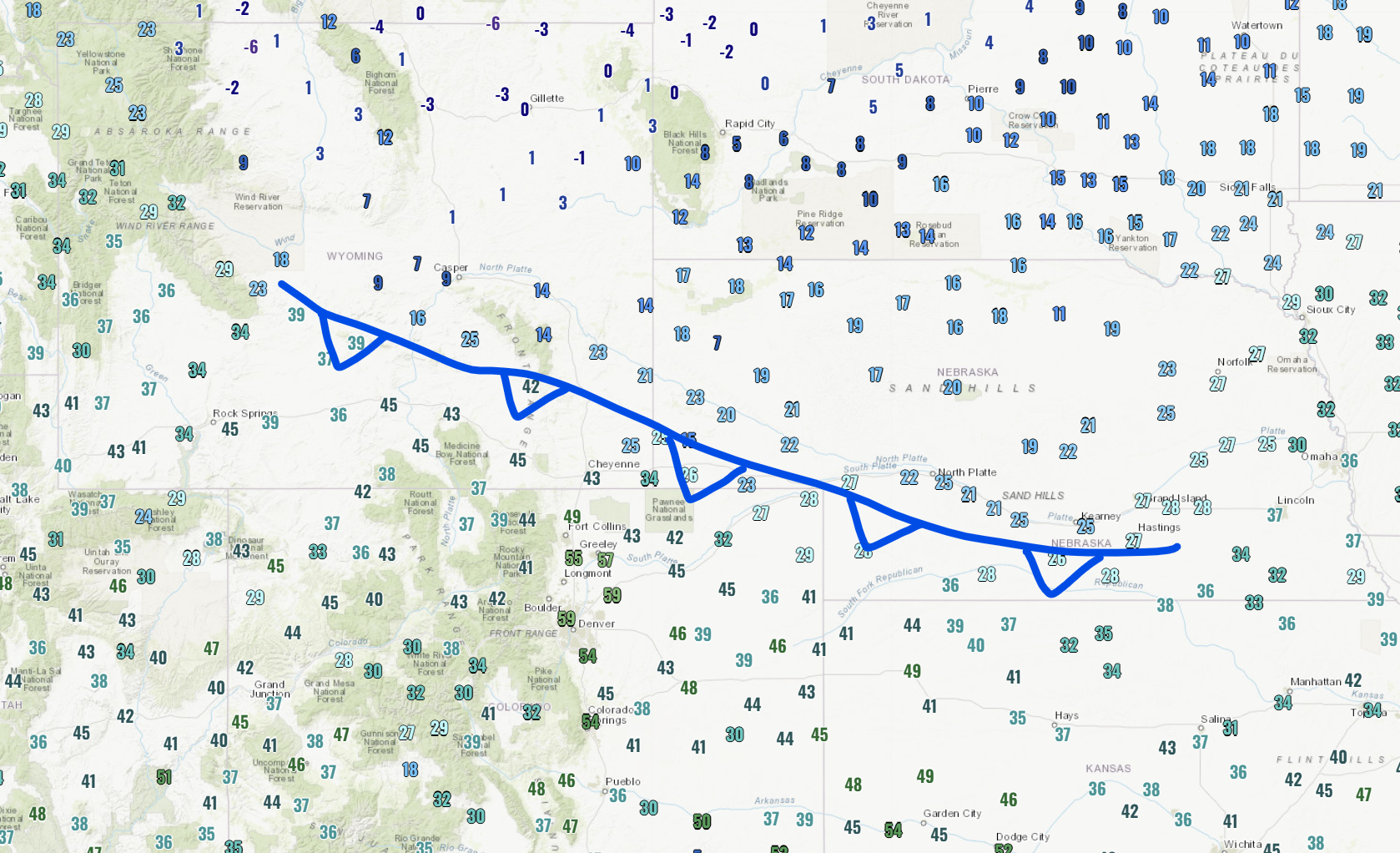
Cold frontal location as of 7AM Monday
While the movement of this front is not entirely certain, there appears to be a general consensus that the front will move through at least portions of our area by Monday afternoon or evening. It is then expected to lift back northward Tuesday before again possibly sagging back south Tuesday night and again wavering back north Wednesday afternoon. As a result, we’ll see cooler highs on Tuesday and Wednesday but still pretty mild in the upper 50s to middle 60s. If the front is further south than currently anticipated, then 50s are possible for portions of the northern Metro area. It’s definitely a tricky forecast for temperatures early in the week, but the general forecast questions will be “How far above normal will our temperatures be?”, more than anything else.
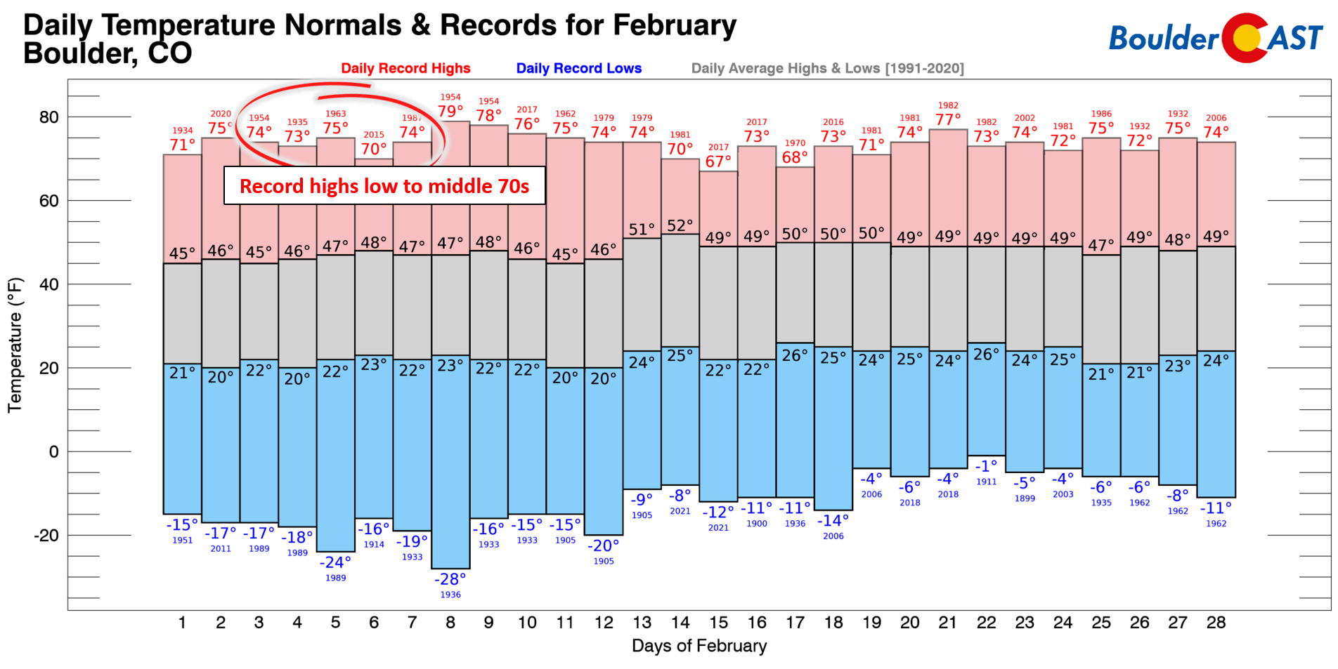
If you’re curious, and we know you are, this week’s warmth won’t get us that close to record highs for early February which are generally all in the lower to middle 70s. Our forecast high on Monday (72°) is within a couple degrees of the record (74°) though!
Watching a wavering cold front
As of Monday morning, the global models are in decent agreement that the wavering cold front will move all the way through our area by early Thursday, dropping our highs later in the week into the 50s. Again, this would still be some 5-10°F above normal. The frontal position in the GFS on Thursday shows it clearly along and south of the Denver area. There is uncertainty as to whether to front waffles back north again on Friday, in which we could warm more than expected, OR if the front lingers and we stay on the cooler side of the 40s to lower 50s. Models should have a better handle on this as we get closer, but for now it is clear that the wavering Arctic airmass will moderate by later in the week, so any impacts for us are expected to be tempered, both in regards to precipitation chances (very low) and the temperature drop (not much). For now expect highs in the lower 50s Thursday but rebounding back into the 60s for Friday.
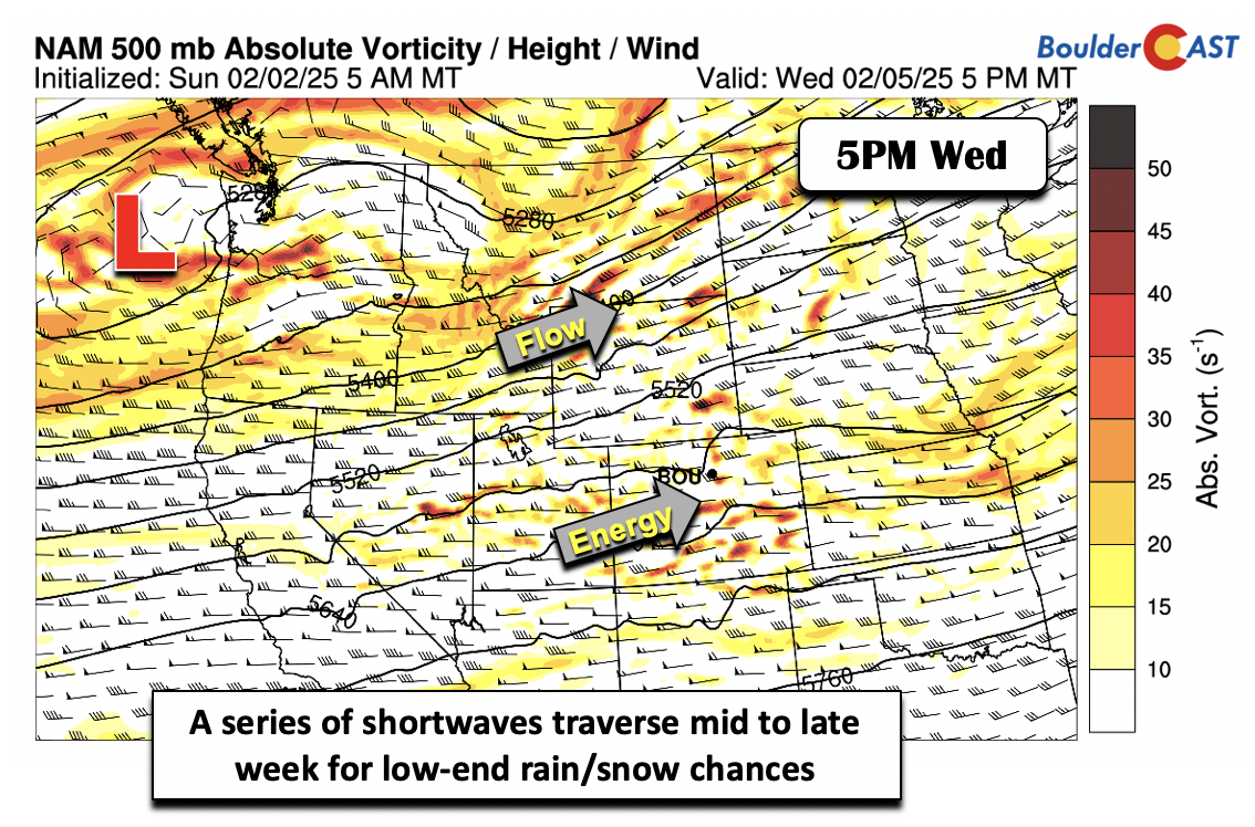
Between Wednesday and Saturday, a series of mid-level shortwave disturbances will traverse the region in the westerly flow aloft thanks to persistent troughing to our northwest. As these systems move eastward, there will be the potential for light rain/snow during this time as the front is nearby, mainly in the Mountains. However, overall confidence is low given the northward storm track and general downslope setup in the Boulder-Denver area. It does look like at least Wednesday will be on the windy side as a result.
Our Snowfall Probabilities show less than 10% chances for an inch or more of snow late-week in Boulder and Denver — yes we most likely remain dry through Friday.
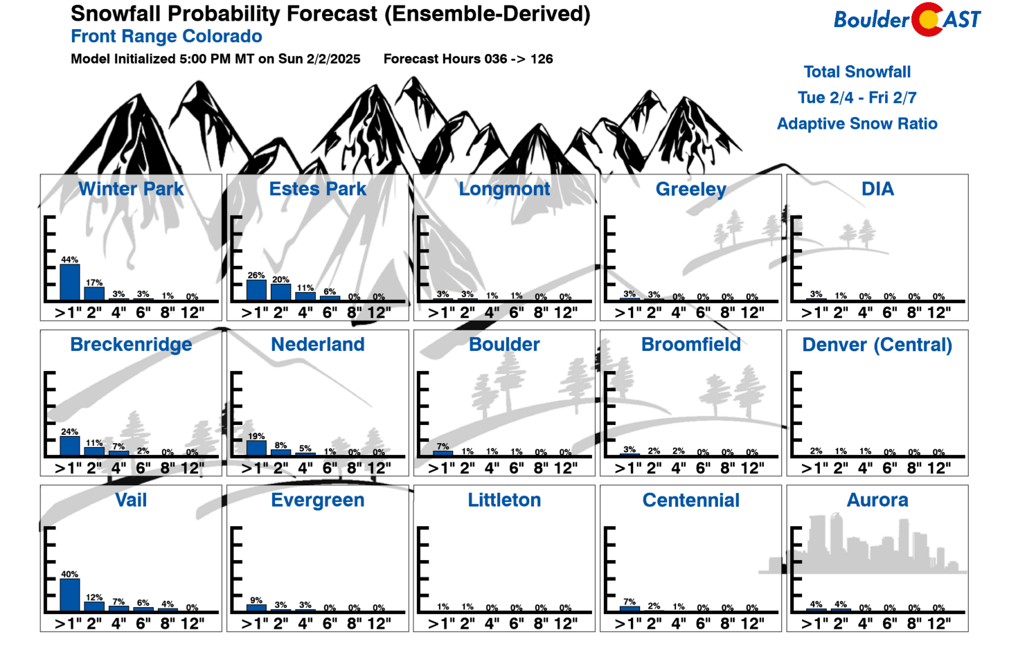
The best chances for picking up a couple inches of white stuff later this week will be in the northern Mountains:
For now, expect limited to no precipitation chances through the week across the lower elevations, with temperatures ranging from somewhat to wildly above normal:
Extended outlook: Wintry weather returns?
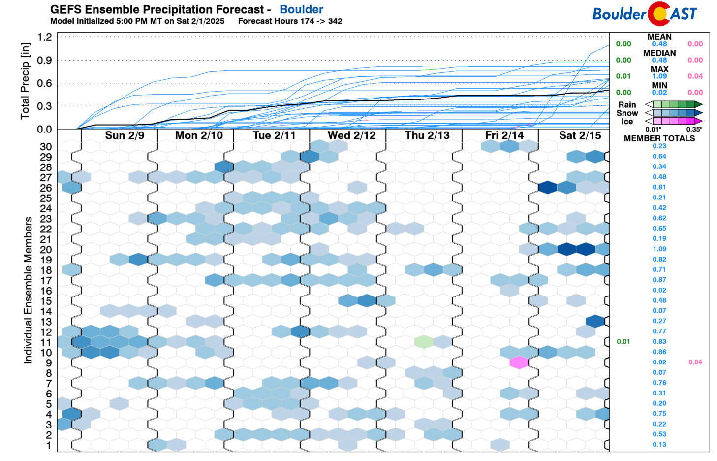
The cold front that modifies across the area later this week may call for reinforcements late in the upcoming weekend or sometime next week, with a secondary push of Arctic air likely to surge southward. At the same time, the storm track is showing a more active pattern, with the GEFS extended range graphic below indicating light snowfall chances across Boulder much of next week. The GEFS is highlighting anywhere from Sunday into Wednesday, which means it cannot pinpoint the exact time of any specific disturbance this far out. Nevertheless, this highlights a better chance of snowfall returning next week to our area.
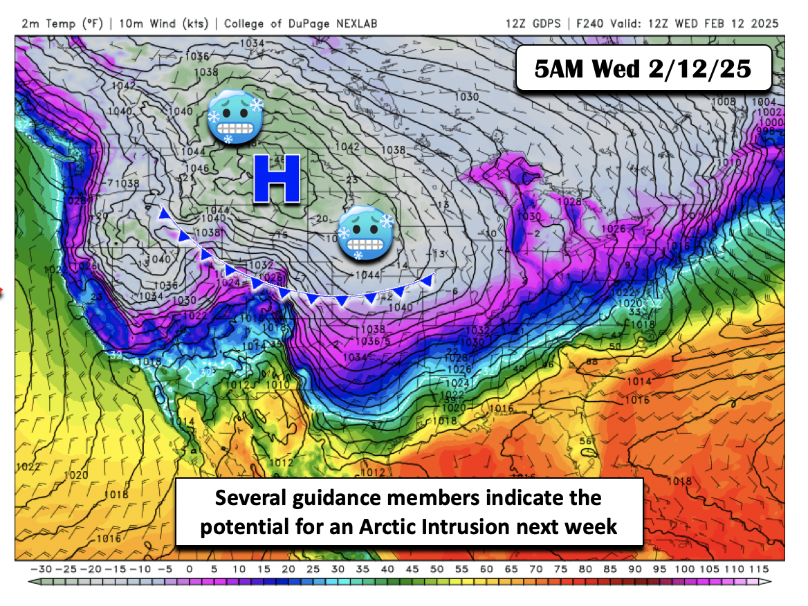
The models are also not consistent on the Arctic airmass early next week, but there are signals from the CMC/ECMWF and GFS that it could reload and penetrate south to engulf much of the Intermountain West and central Plains. The CMC surface temperature forecast below is for next Wednesday (February 12th). The CMC is the coldest of the guidance, but the ECMWF also indicates this colder shift. If this were to happen, it could be some of the coldest air so far this winter, perhaps rivaling what we experienced back in the middle of January.
The GEFS 10-day temperature forecast shows this downward trend from the weekend and into Monday, so this will be something to watch, especially given a potentially more active storm track.
Stay tuned — those imposter weather forecasting rodents may just turn out correct if this cold air intrusion in the extended verifies!
Forecast Specifics:
Monday: Partly sunny and gusty with near-record warmth. High temperatures in the lower 70s on the Plains with near 60 in the Foothills by early afternoon. Wind gusts of 20-40 MPH will be possible, strongest in the morning hours in/near the Foothills. A strong cold front will impact the area during the afternoon to early evening with temperatures falling below freezing by evening.
Tuesday: Lower highs but still mild with upper 50s on the Plains and upper 40s in the Foothills.
Wednesday: Gusty but with mostly sunny skies. Highs in the lower to middle 60s for the Plains and low 50s in the Foothills. West winds could gust to 30 MPH.
Thursday: Mostly sunny with a low-end chance of light rain/snow, mainly in the Mountains. Otherwise cooler with highs in the low 50s on the Plains and lower 40s in the Foothills.
Friday: Mostly sunny and likely dry. Temperatures warmer in the lower 60s on the Plains with upper 40s in the Foothills. Highs could be colder or warmer depending on the location of a late-week cold front. There is also a low-end chance of rain/snow mix Friday night.
Weekend: A downward trend in temperatures is expected. The weekend could bring a low-end rain/snow chance, but uncertainty is too high to expect that at this time. Highs will drop below average into the 40s and eventual 30s or colder next week.
Get BoulderCAST updates delivered to your inbox:
DISCLAIMER: This weekly outlook forecast is created Monday morning and covers the entire upcoming week. Accuracy will decrease as the week progresses as this post is NOT updated. To receive daily updated forecasts from our team, among many other perks, subscribe to BoulderCAST Premium.
Go Premium, get all the perks.
Daily Forecast Updates
Get our daily forecast discussion every morning delivered to your inbox.
All Our Model Data
Access to all our Colorado-centric high-resolution weather model graphics. Seriously — every one!
Ski & Hiking Forecasts
6-day forecasts for all the Colorado ski resorts, plus more than 120 hiking trails, including every 14er.
Smoke Forecasts
Wildfire smoke concentration predictions up to 72 hours into the future.
Exclusive Content
Weekend outlooks every Thursday, bonus storm updates, historical data and much more!
No Advertisements
Enjoy ad-free viewing on the entire site.
Enjoy our content? Give it a share!


You must be logged in to post a comment.