A cold snap sets in to start the week, along with heavy snowfall for the higher terrain. A slow warming trend takes shape come Wednesday but doesn’t get into full-swing until the weekend. Read on for more details.
Cold and windy with slight chance of snow to start
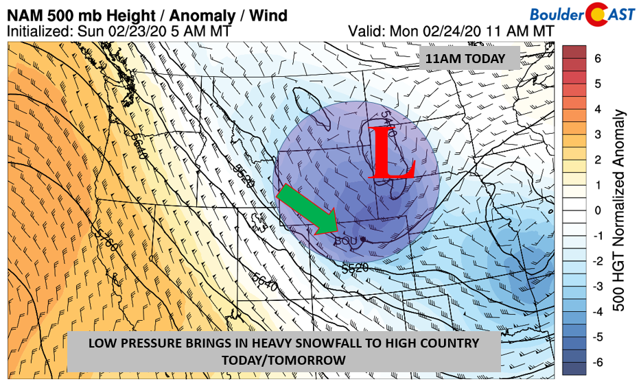
The week kicks off with a continued active pattern. Shown below is the 500 mb height and anomaly pattern over the western U.S. The focus for us today is an area of low pressure over southwest South Dakota. The system will take a east-southeast track into the Midwest later today and tonight. The track is not favorable for snow on the Front Range due to its downslope nature. However, it does pack a punch in terms of wind and cold temperatures later today and into tomorrow.
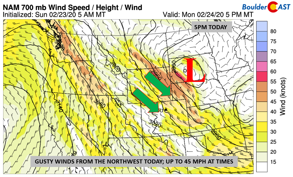
Highs today will start out in the lower 40’s but then drop into the 30’s as the afternoon wears on. We may see a brief snow shower here and there with the cold frontal passage, but most of us will remain dry under partly cloudy skies. As the cold air filters in, so will the wind. Northwest winds 5,000 or so feet up (below) approach 45 to 50 mph. That northwest flow blowing across the higher terrain to our west will make for a blustery afternoon and early evening on Monday. Winds may gust to 45 mph creating a decently cold wind chill in the afternoon and early evening; winds should taper off later in the evening.
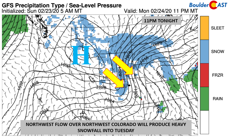
The High Country and ski resorts are best positioned with this storm system today to see accumulating snowfall (below). With a large area of high pressure to our northwest in Idaho, and general low pressure to our southeast, this will create a tight pressure gradient to bolster those northwest winds. Northwest facing slopes of the mountains can expect heavy snowfall totals into Tuesday. Although the moisture is below average, all that upslope will squeeze out the snow.
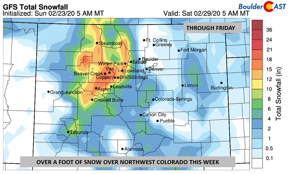
Snow totals through Friday will likely be over a foot in many locations to our west and northwest (below). The majority of this snow will fall today and tomorrow, with a secondary (weaker) system on Wednesday producing additional light accumulations. The best days for fresh powder are Tuesday and Wednesday!
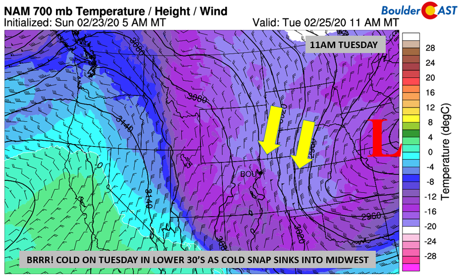
By Tuesday, the cold air will be fully entrenched across the state. Notice in the graphic below how the sub-freezing temperatures stretch from Canada, all the way down into Arizona and southern New Mexico. It will be cold tomorrow with upper 20’s to near 30 degrees for high temperatures. As the flow turns from northwest Monday night to north-northeast on Tuesday, some light snow showers or flurries cannot be ruled out. However, these should not amount to much, generally 1/2″ at best!
A warming trend come midweek but that “chill” remains until the weekend
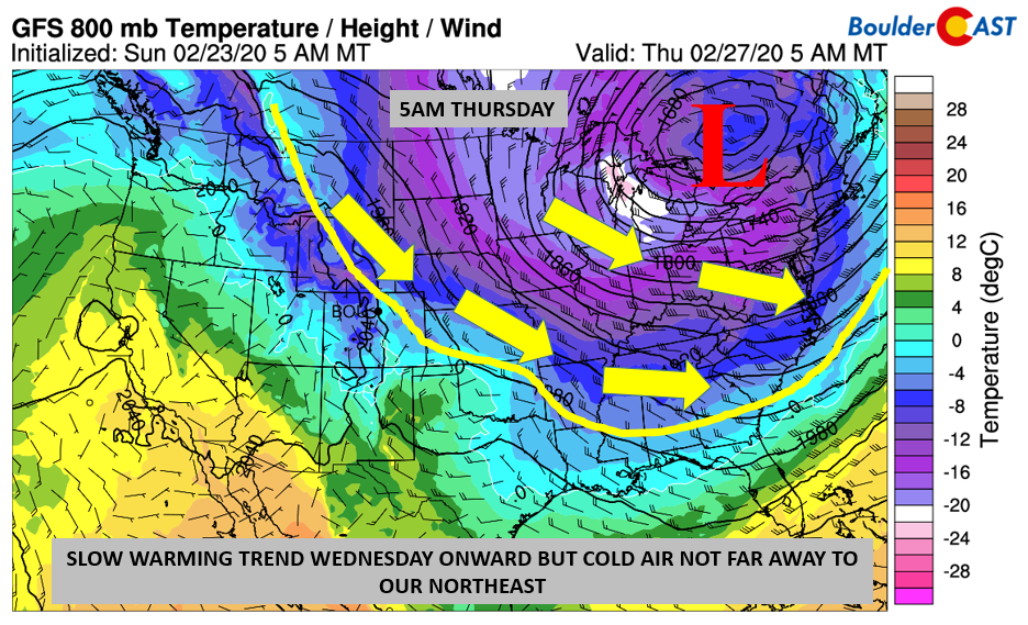
Come Wednesday and onward, the jet stream will slowly shift from “over us” toward the Midwest. Shown below is the low-level temperature pattern, with the solid yellow line indicating the approximate location of freezing temperatures. To the north of this line is below freezing, while warmer air is south of this. A nice warm-up takes shape Wednesday thanks to a brief downslope flow – low to middle 40’s under sunshine is likely. The jet stream, however, will be meandering every so slightly just to our east-northeast along the Colorado/Wyoming and Colorado/Nebraska borders. A weak wave passes through Wednesday night and another Thursday night, keeping the area from fully exiting the chilly northwest flow. Long story short: expect a slow warming trend Wednesday onward from the low to middle 40’s to maybe 50’s by Friday. We’ll just have to keep an eye on the weaker cool fronts Thursday and Friday. If they track more over us, we’ll stay chilly. But if they stay to our east, we’ll warm up a little faster. Our current forecast is a blend of the two outcomes.
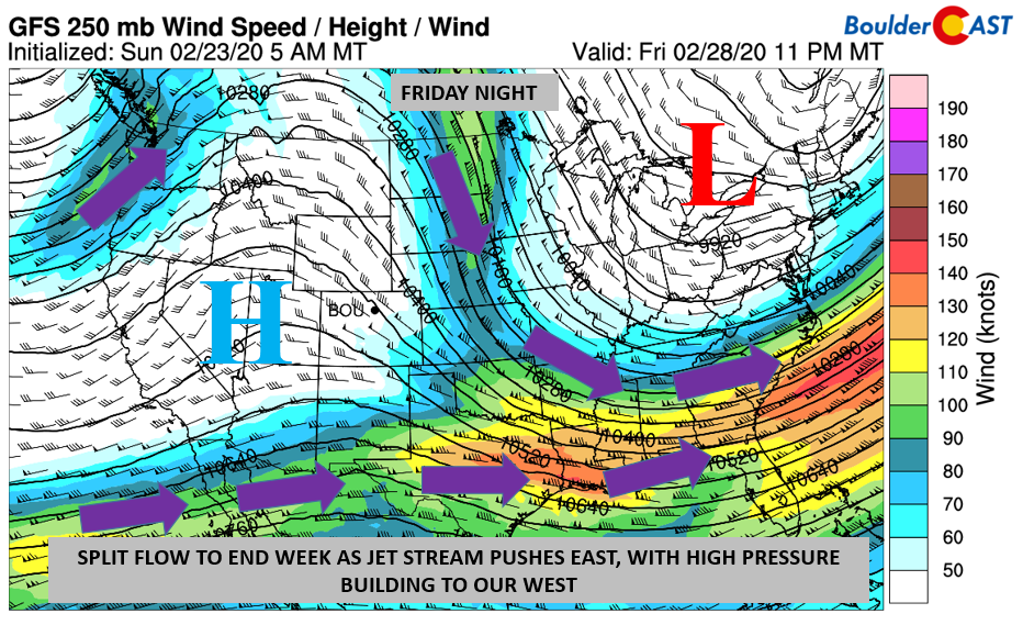
As we work into Friday and the upcoming weekend, the jet stream looks to fully move out, staying out in the Midwest and Great Lakes (below). Colorado will more or less be in a “split” flow pattern. That means that the polar jet stream (Midwest and southeastern U.S.) will be to our east. The subtropical jet stream (Mexico into Florida from west to east) will be to our south. High pressure will slowly work in Friday and spell out a nice warm-up for the weekend with highs pushing back towards 60 degrees.
Forecast Specifics:
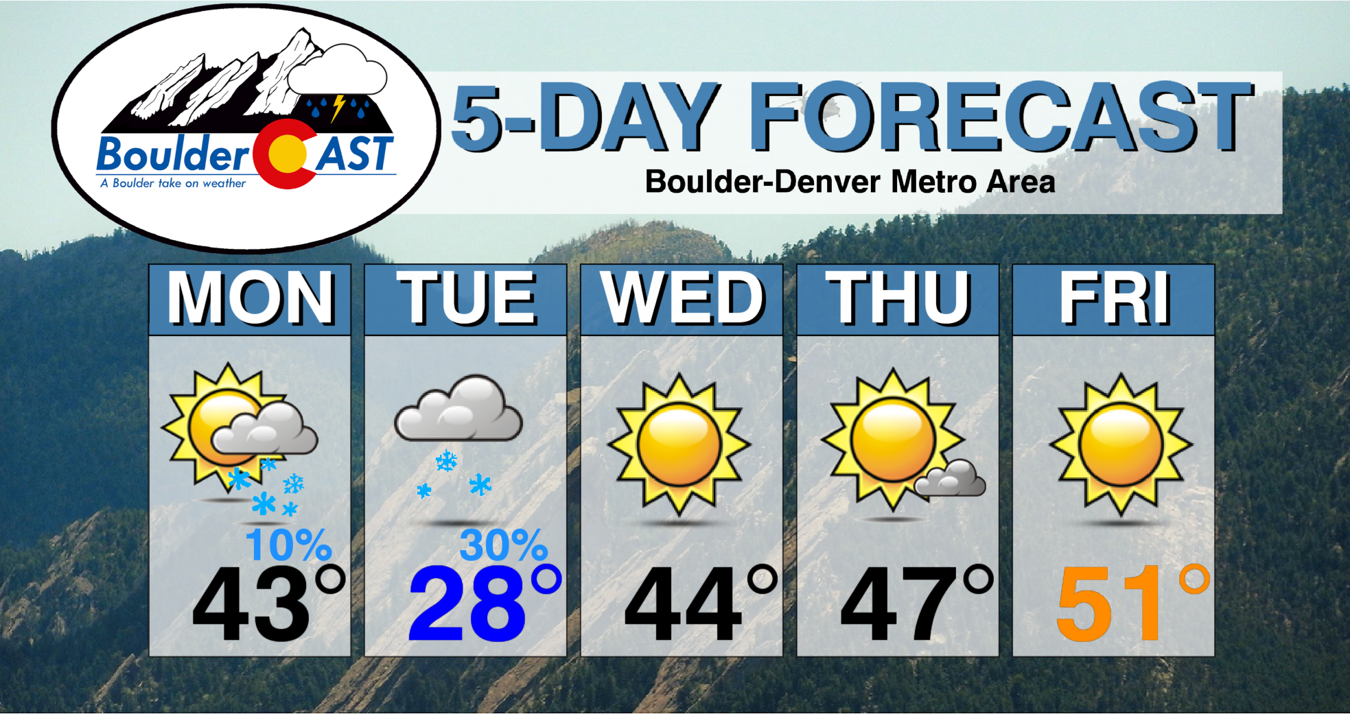
Monday: Clouds giving way to a mixture of clouds and sunshine with just a slight chance of snow showers/flurries. Turning cold after lower 40’s on the Plains and lower 30’s in the Foothills. Temperatures on the Plains to drop into the 30’s as the day wears on. Windy out of the northwest, at times up to 45 mph gusts on the Plains and 55 mph in the Foothills.
Tuesday: Partly to mostly cloudy with a chance of light snow during the day. A dusting or so of accumulation is possible. Highs near 30 degrees on the Plains and lower 20’s in the Foothills.
Wednesday: Mostly sunny and warmer. Highs in the low to middle 40’s on the Plains and lower 30’s in the Foothills.
Thursday: Partly cloudy skies with highs near the upper 40’s on the Plains and middle 30’s in the Foothills.
Friday: Turning sunny and warmer with highs in the upper 40’s or lower 50’s on the Plains, and upper 30’s in the Foothills.
The Weekend: Looking warmer with highs in the 50’s to lower 60’s. Most likely it will be dry.
High Country: A fresh dumping of snow will fall over the ski resorts today into tomorrow afternoon. Places will see over a foot of snow in spots. The best day to ski with that fresh POW will be Tuesday and Wednesday. Another weak system passes Wednesday and Thursday, with a light accumulation with these two. Check our PowderCAST page for always-updated weather forecasts for all of the Colorado ski resorts.
DISCLAIMER: This weekly outlook forecast is created Monday morning and covers the entire upcoming week. Accuracy will decrease as the week progresses as this post is NOT updated. To receive daily updated forecasts from our team, subscribe to BoulderCAST Premium.
.
Spread the word, share our forecast!




You must be logged in to post a comment.