Largely near to above normal temperatures will be the story for the upcoming week, with even some 60s on Tuesday as high pressure and downslope flow dominate our weather pattern. However, we are watching a few systems that will track through Colorado in the coming days — one from the southwest around midweek and a second from the northwest on Friday. The latter has more uncertainty but the former also shares in a fair bit of spread on potential rain/snow impacts. Read on as we discuss in detail our weather for the upcoming week.
This week’s highlights include:
- A Seasonal to Warm Week Overall: We stay mild through Wednesday with highs in the 50s to middle 60s before turning somewhat cooler Thursday and Friday
- Cold Front on Wednesday: A cold front will arrive late Wednesday bringing a chance of rain/snow mixture into Thursday — accumulations should be light (1″ or less of wet snow)
- Mountain Snow: A remnant atmospheric river from California will spread snow into the Mountains midweek, with generally less than 6″ statewide through the week
- A Gorgeous Upcoming Weekend: High pressure surges back in for the weekend with 60-degree temperatures returning to the Front Range

DISCLAIMER: This weekly outlook forecast is created Monday morning and covers the entire upcoming week. Accuracy will decrease as the week progresses as this post is NOT updated. To receive daily updated forecasts from our team, among many other perks, subscribe to BoulderCAST Premium.

Go Premium, get all the perks.
Daily Forecast Updates
Get our daily forecast discussion every morning delivered to your inbox.
All Our Model Data
Access to all our Colorado-centric high-resolution weather model graphics. Seriously — every one!
Ski & Hiking Forecasts
6-day forecasts for all the Colorado ski resorts, plus more than 120 hiking trails, including every 14er.
Smoke Forecasts
Wildfire smoke concentration predictions up to 72 hours into the future.
Exclusive Content
Weekend outlooks every Thursday, bonus storm updates, historical data and much more!
No Advertisements
Enjoy ad-free viewing on the entire site.
Warming up to start
Sunday was a gorgeous day across the Front Range which allowed our recent snow to continue to melt down across the lower elevations and in the Foothills. This week will continue that trend of warmer weather. A weak system from Sunday has now shifted east into Kansas. In its wake, ridging will start to spread into Utah and Colorado Monday afternoon and evening. A large storm system resides offshore of the western U.S. and will be something we discuss a bit later.
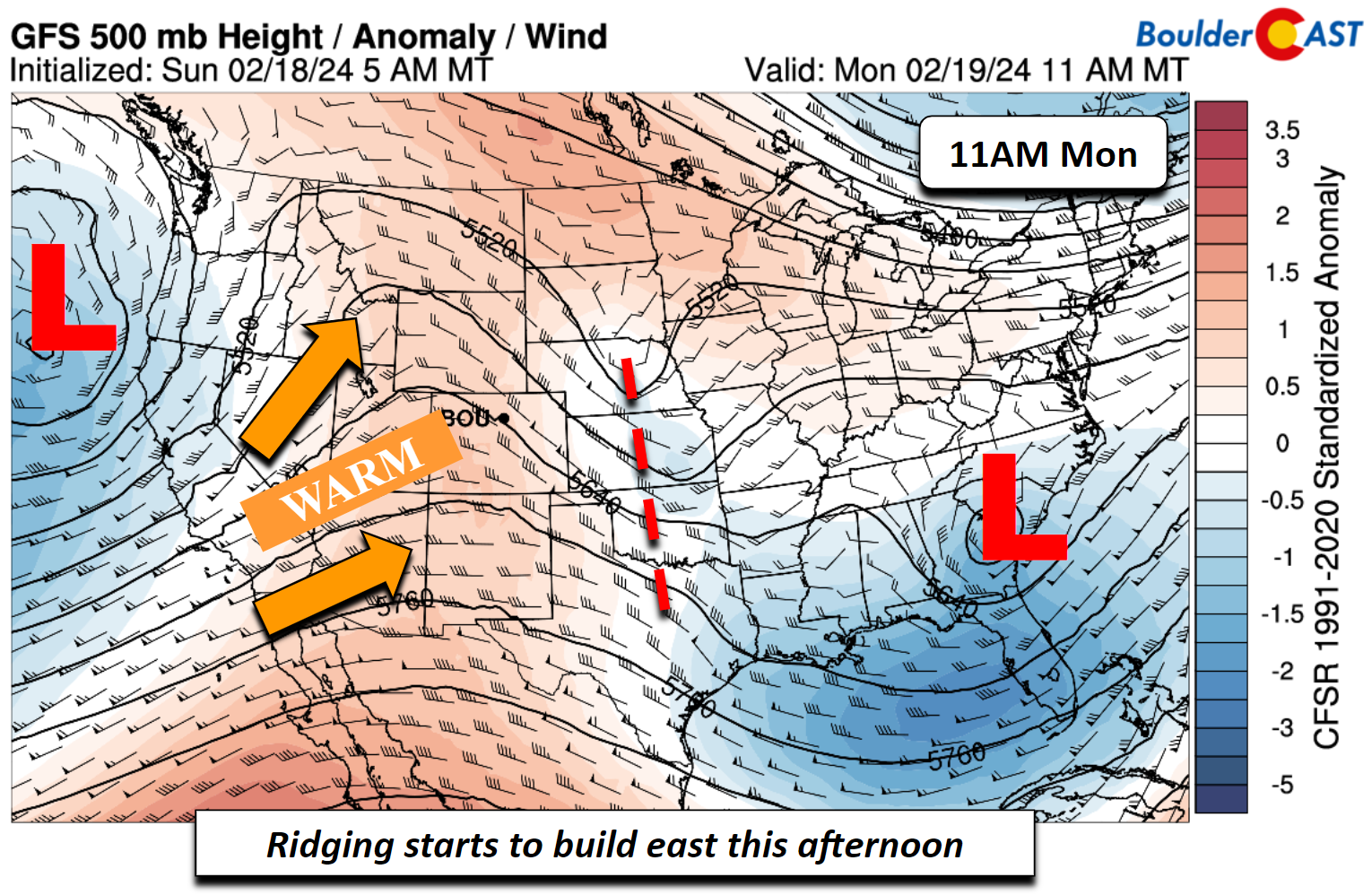
We were in the upper 40s to lower 50s on Sunday and for Monday we should have no issues getting into the middle to upper 50s.
By Tuesday, the aforementioned ridge strengthens and further tracks eastward toward the central and southern Plains. The warmest airmass associated with this ridge will be in place over Colorado on Tuesday.
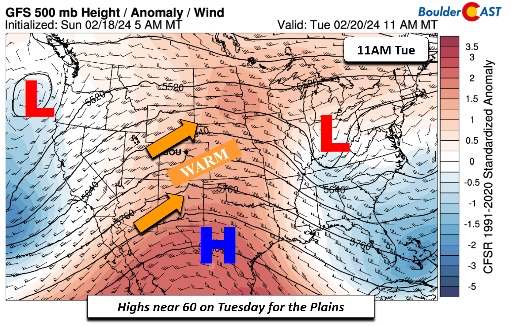
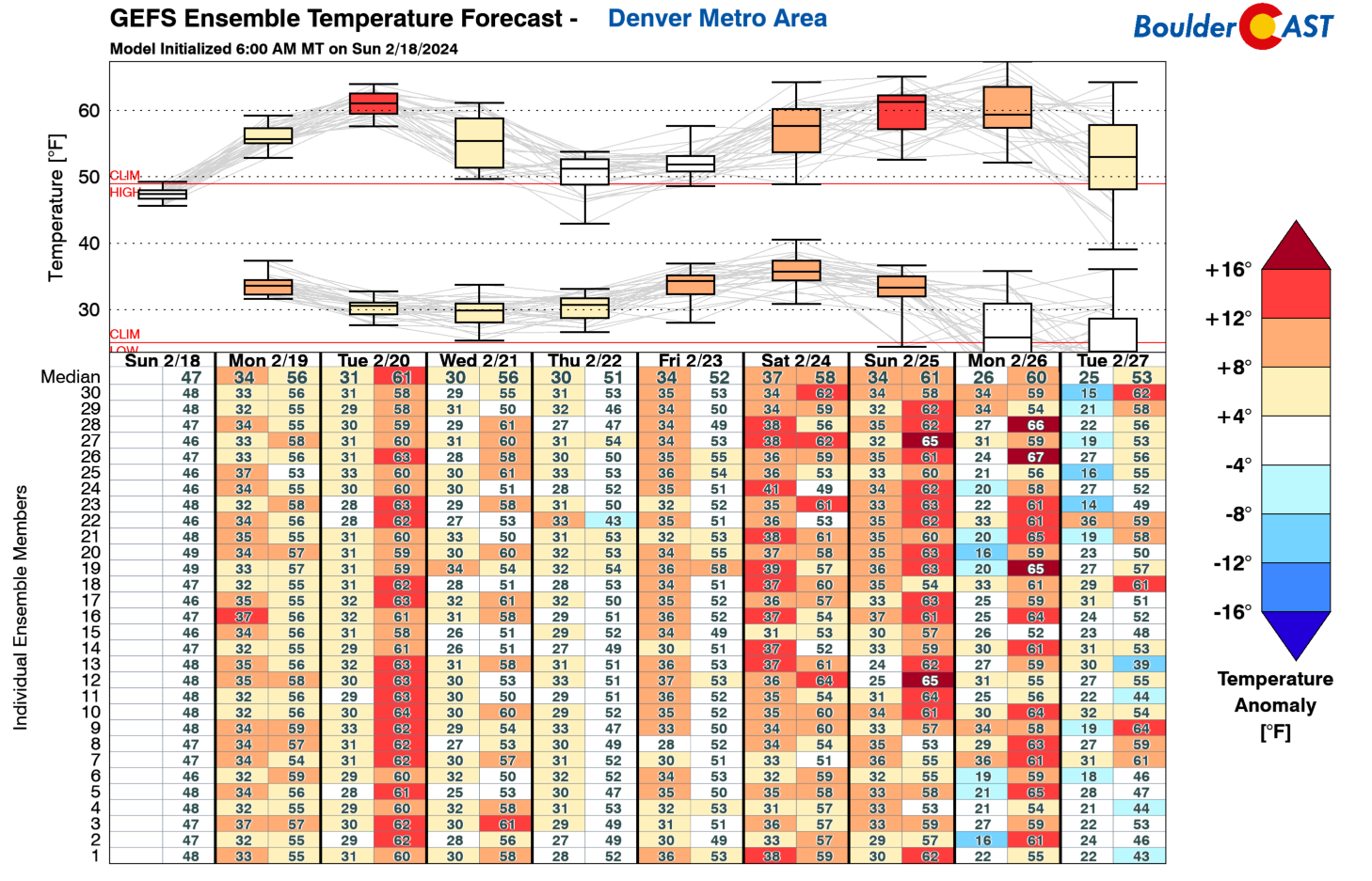
Temperature anomalies for our Tuesday will range from 1 to 3 deviations above normal. This will be supportive of middle 60s across portions of the Denver Metro area. In Boulder, highs may be a few degrees cooler in the lower 60s. Nevertheless, Tuesday is the best day of the week to get outside before or after work!

Below shows the temperature trends for the week from the GEFS ensembles. Note that Tuesday looks to be our warmest day with the ridge overhead — lower to middle 60s are favored. We are tracking a cooldown come Wednesday through Friday, but temperatures will still be staying near or above normal. Then for the upcoming weekend, another warming trend will ensue with highs likely to push into the 60s again.
A few systems to watch mid to late week
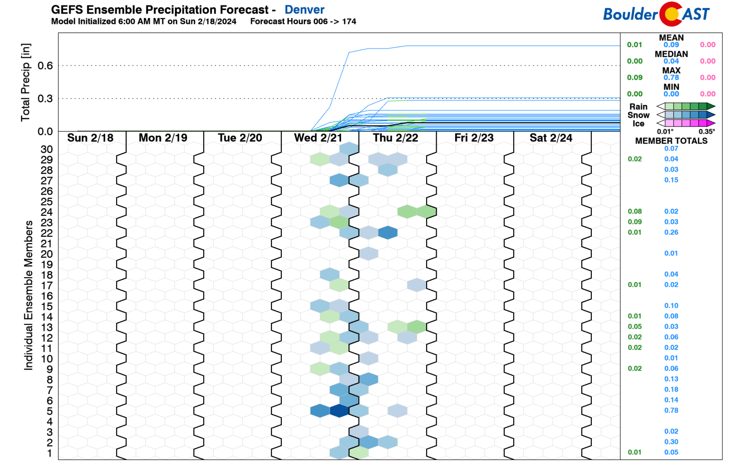
We are watching a midweek system that will move onshore Tuesday night and track across Colorado from the southwest Wednesday afternoon and into Thursday — the remnants of another fierce atmospheric river slamming California. The system will take a southwest to northeast track across southeastern Colorado and into Kansas. This track is not optimal for true precipitation on the Plains given the downslope nature to these systems. However, there does appear to be enough forcing for a light rain/snow mix.
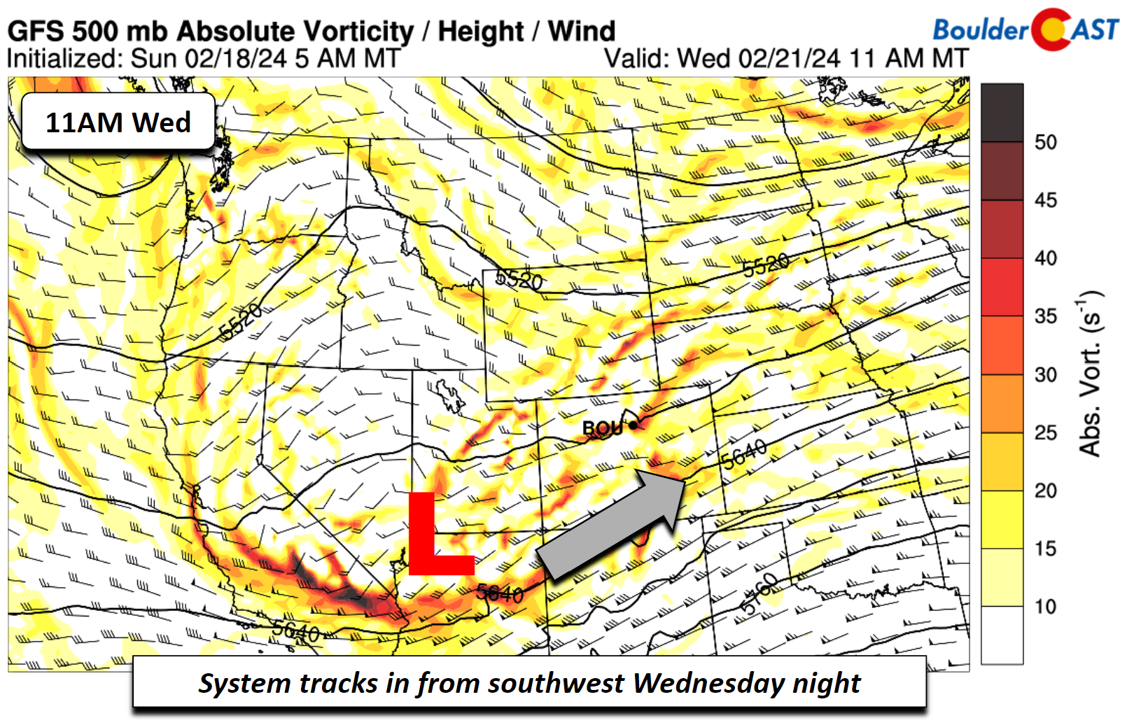
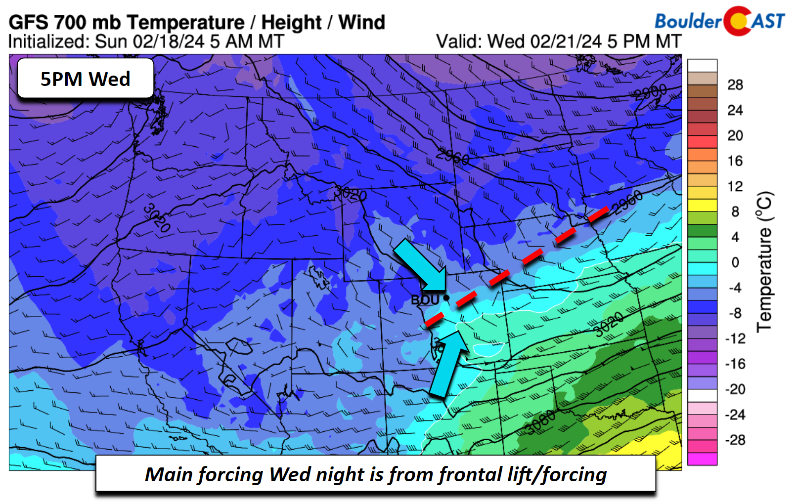
A cold front will be moving south late Wednesday and that will aid the main lift for rain changing to snow late Wednesday night into perhaps midday Thursday. One downside of this system is that it will have little if any jet forcing. The upslope flow is nearly non-existent in the latest model trends as well. The only real forcing is from frontal lift/convergence, shown below. If things change, we could be talking about a different outcome— but for now, the impact of this mid-week system looks minimal across the Front Range.
Below is the GFS snow accumulation forecast through Friday. It shows little to no accumulation on the Plains and confines any snow to the Foothills and Mountains. The Park Range near Steamboat should see upwards of 10″ of snow this week — while the rest of the mountain ranges in the state pick up less than 6″.
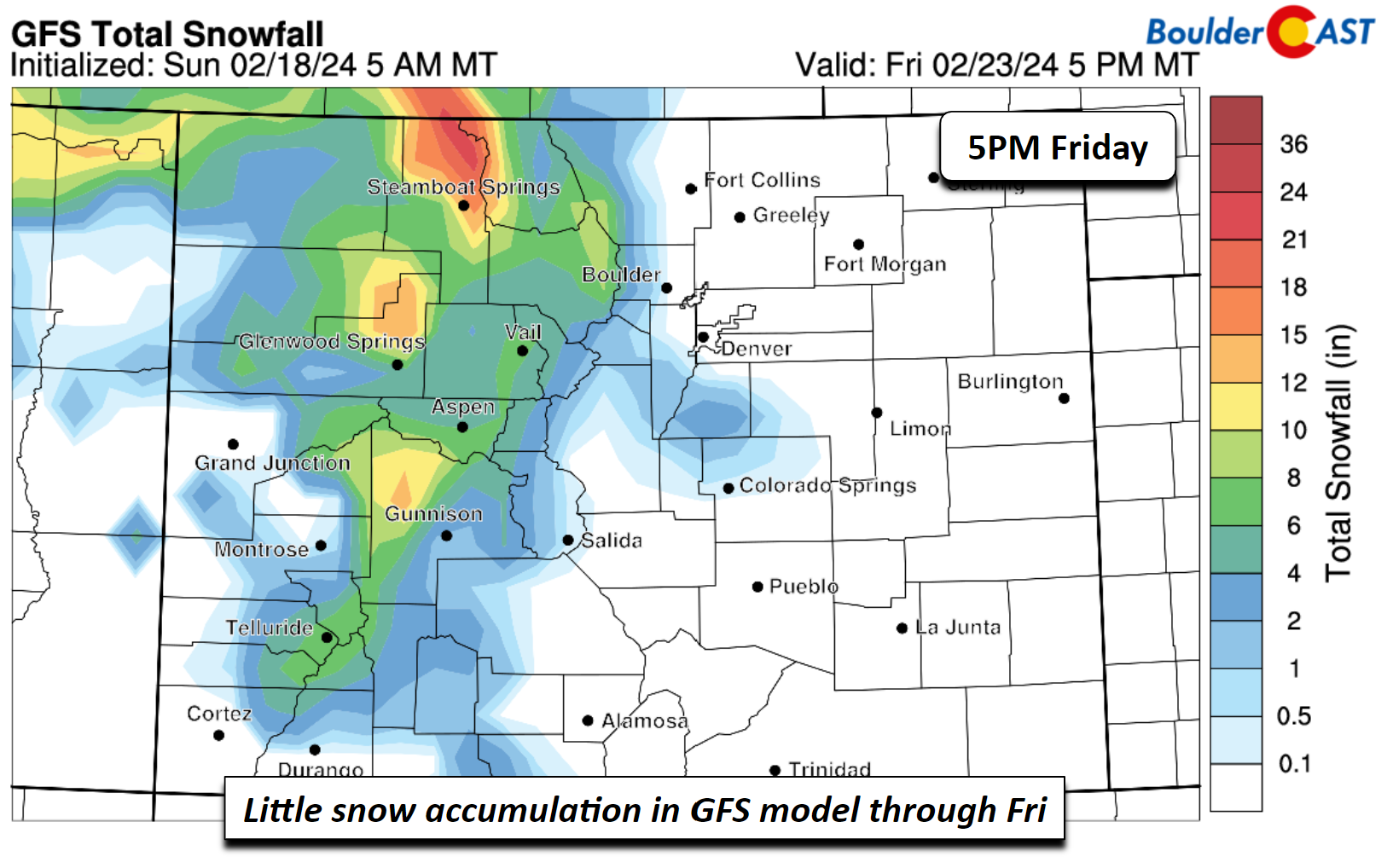
The GEFS ensemble is also quite consistent, showing a chance of some low-end accumulation as rain transitions to light snow across the area — with perhaps a dusting to 1″ of wet accumulation. This is something we will continue to monitor but for now the main story will be the downward trend in high temperatures for the remainder of the week. Highs Wednesday will likely range from the mid to upper 50s ahead of the cold front and drop to the upper 40s to near 50 for the remainder of the week behind the front.
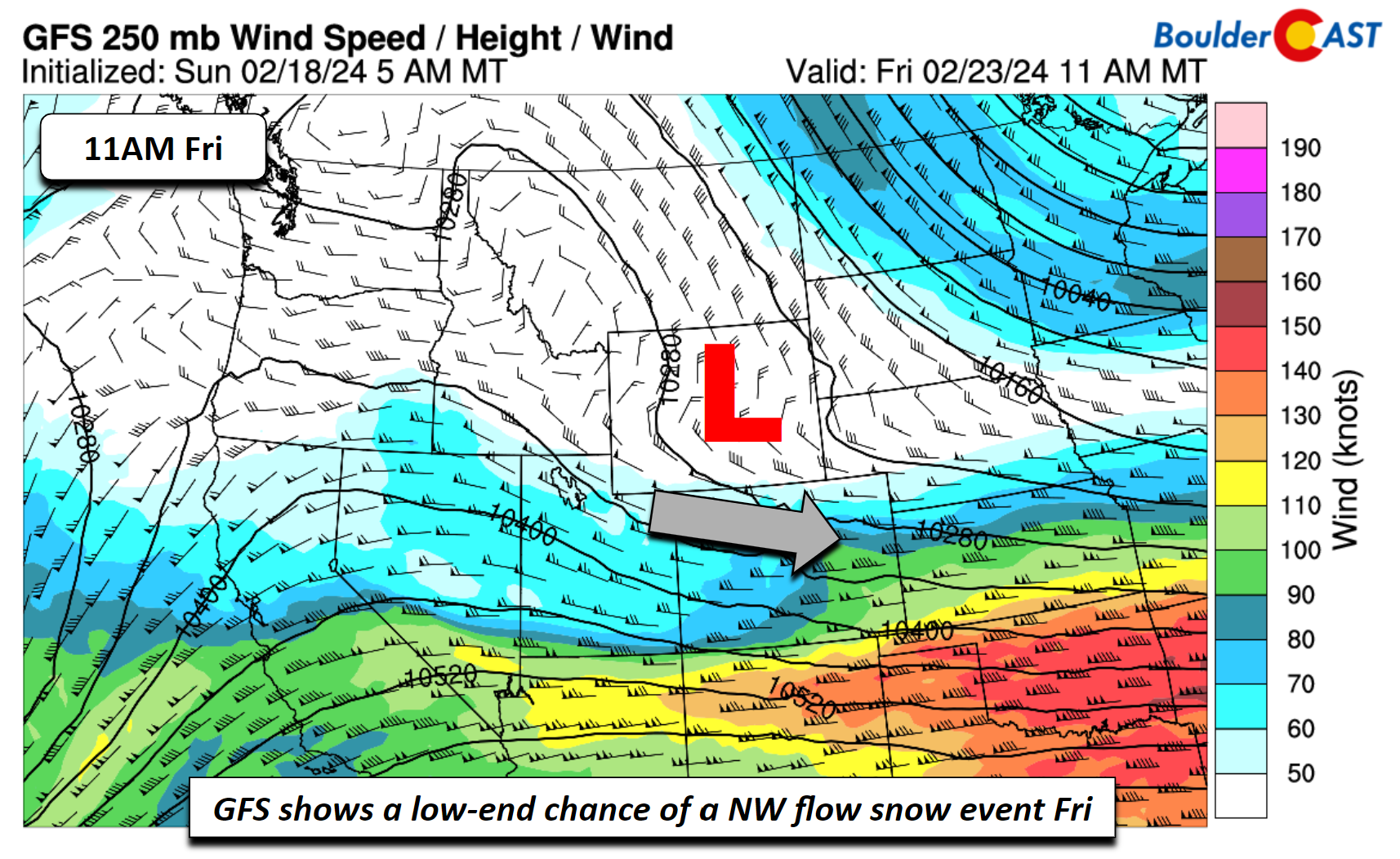
Beyond the rain/snow chance, the extended looks largely dry, but an outlier solution from the GFS indicates a northwesterly flow system that could bring a chance of snow on Friday or early Saturday. Note that this solution is not shared by the Canadian or Euro models, which largely favor ridging building in faster than the GFS. We’ll keep the forecast dry for now but just wanted to mention there is late-week model disagreement.
Below is our planner for the week ahead. Overall, it’ll be a great week with just a dabble of rain/snow bookended by copious sunshine and mild temperatures!
Enjoy!
Did you see the textbook example of anti-crepuscular rays in #Boulder Sunday evening? These are shadows of sorts which converge on the horizon 180 degrees from where the sun is located! #COwx
📸: Sandy Dietrich pic.twitter.com/Cq7xIVWlvD
— BoulderCAST Weather 🏔️❄️ (@BoulderCAST) February 19, 2024
Get BoulderCAST updates delivered to your inbox:
Forecast Specifics:
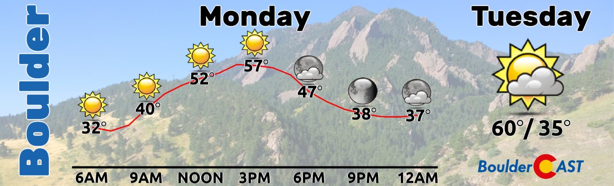
Monday: Mostly sunny and warmer with middle 50s for the Plains and low to mid 40s in the Foothills.
Tuesday: Increasing clouds and warmer still with 60s on the Plains and 50s in the Foothills.
Wednesday: Partly to mostly cloudy with a chance of rain/snow in the evening/overnight. Highs in the mid to upper 50s for the Plains and upper 40s in the Foothills. A dusting to 1″ of snow may occur overnight into Thursday.
Thursday: A chance of some snow showers lingering in the morning, then partly to mostly sunny by the afternoon. Highs in the upper 40s for the Plains and upper 30s in the Foothills.
Friday: Mostly sunny with highs near 50 on the Plains and upper 30s in the Foothills.
Weekend: Highs may rebound into the 60s over the latter part of the weekend, along with continued dry weather in store. For the first time in a month, we won’t be shoveling snow Saturday morning!
DISCLAIMER: This weekly outlook forecast is created Monday morning and covers the entire upcoming week. Accuracy will decrease as the week progresses as this post is NOT updated. To receive daily updated forecasts from our team, among many other perks, subscribe to BoulderCAST Premium.
Go Premium, get all the perks.
Daily Forecast Updates
Get our daily forecast discussion every morning delivered to your inbox.
All Our Model Data
Access to all our Colorado-centric high-resolution weather model graphics. Seriously — every one!
Ski & Hiking Forecasts
6-day forecasts for all the Colorado ski resorts, plus more than 120 hiking trails, including every 14er.
Smoke Forecasts
Wildfire smoke concentration predictions up to 72 hours into the future.
Exclusive Content
Weekend outlooks every Thursday, bonus storm updates, historical data and much more!
No Advertisements
Enjoy ad-free viewing on the entire site.
Enjoy our content? Give it a share!


You must be logged in to post a comment.