Above average temperatures and sunshine kick off the week under a large anomalous dome of high pressure. A cooling trend ensues to end the week, along with a chance of snow, although uncertainty exists in the exact track of the storm system. Read on for more details.
This week’s highlights include:
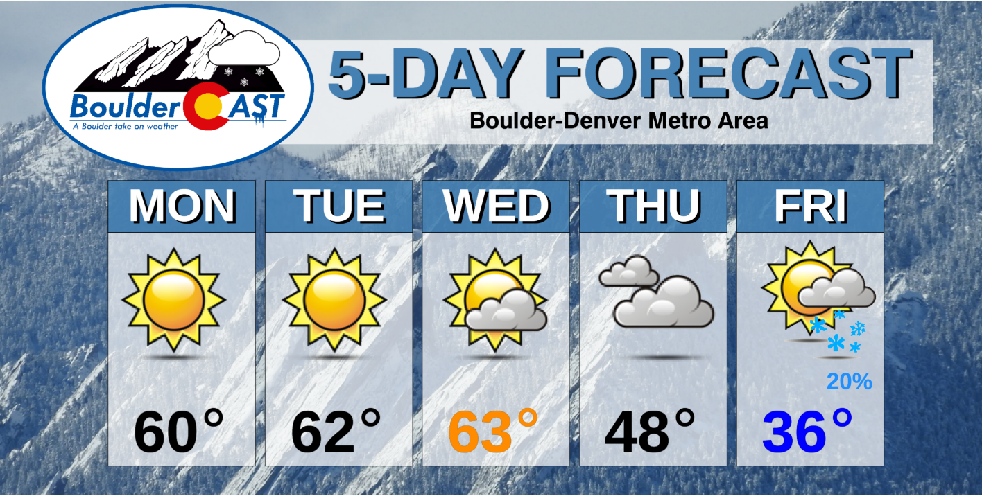
- A beautiful start to the week with low to middle 60’s through Wednesday
- More seasonal to below average late in the week
- A chance of snow Thursday/Friday, though plenty of uncertainty exists
DISCLAIMER: This weekly outlook forecast is created Monday morning and covers the entire upcoming week. Accuracy will decrease as the week progresses as this post is NOT updated. To receive daily updated forecasts from our team, subscribe to BoulderCAST Premium.
Above average through Wednesday
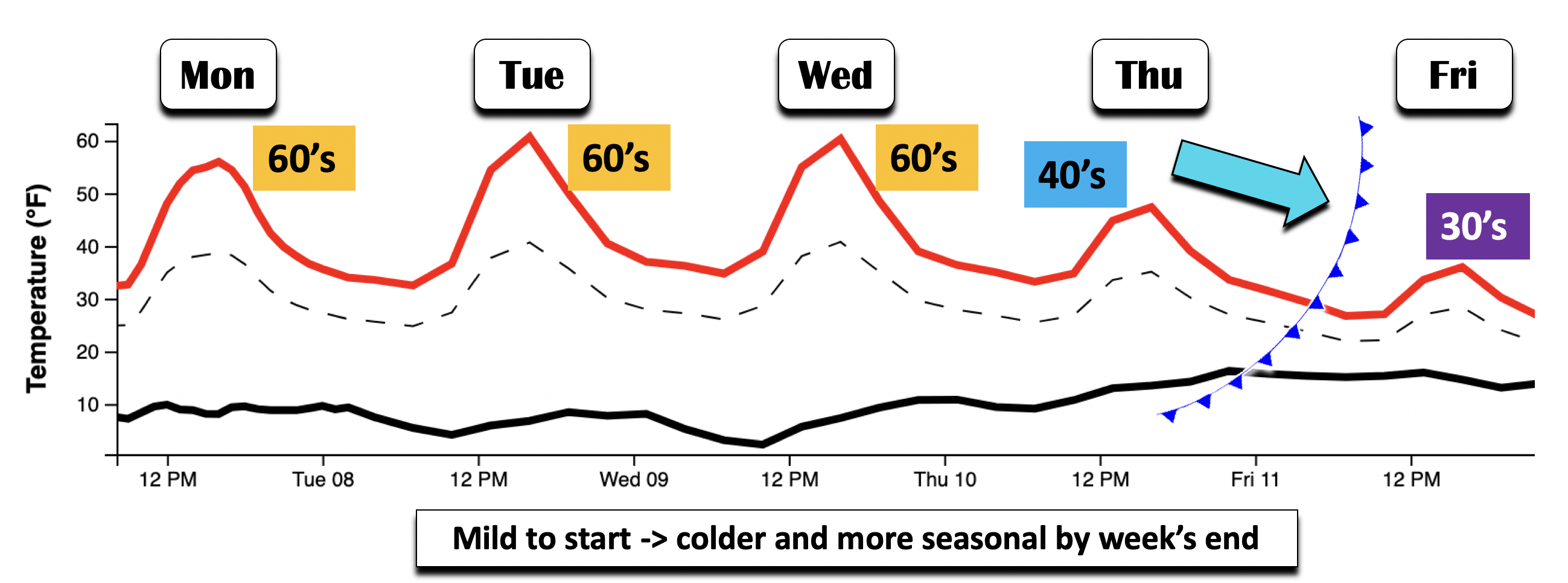
The graphic below shows the overall trend in temperatures (solid red line) and dewpoints (solid black line) this week. The main story is well above average temperatures through Wednesday, with a trend to more seasonal/below average conditions by week’s end. Our normal highs for this week in December are in the middle 40’s. Thus, highs in the 60’s through Wednesday puts us 15 to 20 degrees above average.
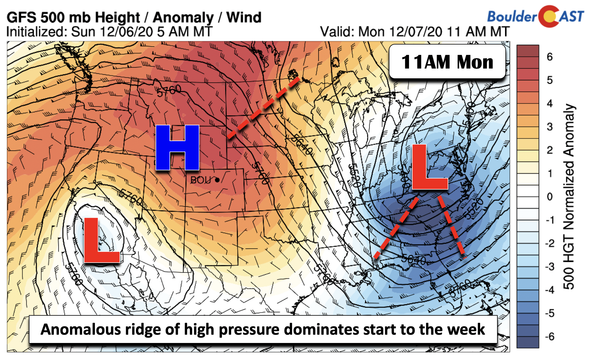
We can attribute the mild and above average weather to a strong ridge of high pressure, currently located over Wyoming (below). This ridge will largely remain in place through midweek, slowly edging south and east by late Wednesday and Thursday as a trough of low pressure approaches from the Pacific Northwest. Elsewhere across the nation today, some light rain/embedded snow showers exist over the higher terrain of the Carolinas tied to a colder airmass and attendant low pressure system. A cut-off low pressure is also present near southern California. This system could be an important player in our late-week snow potential.
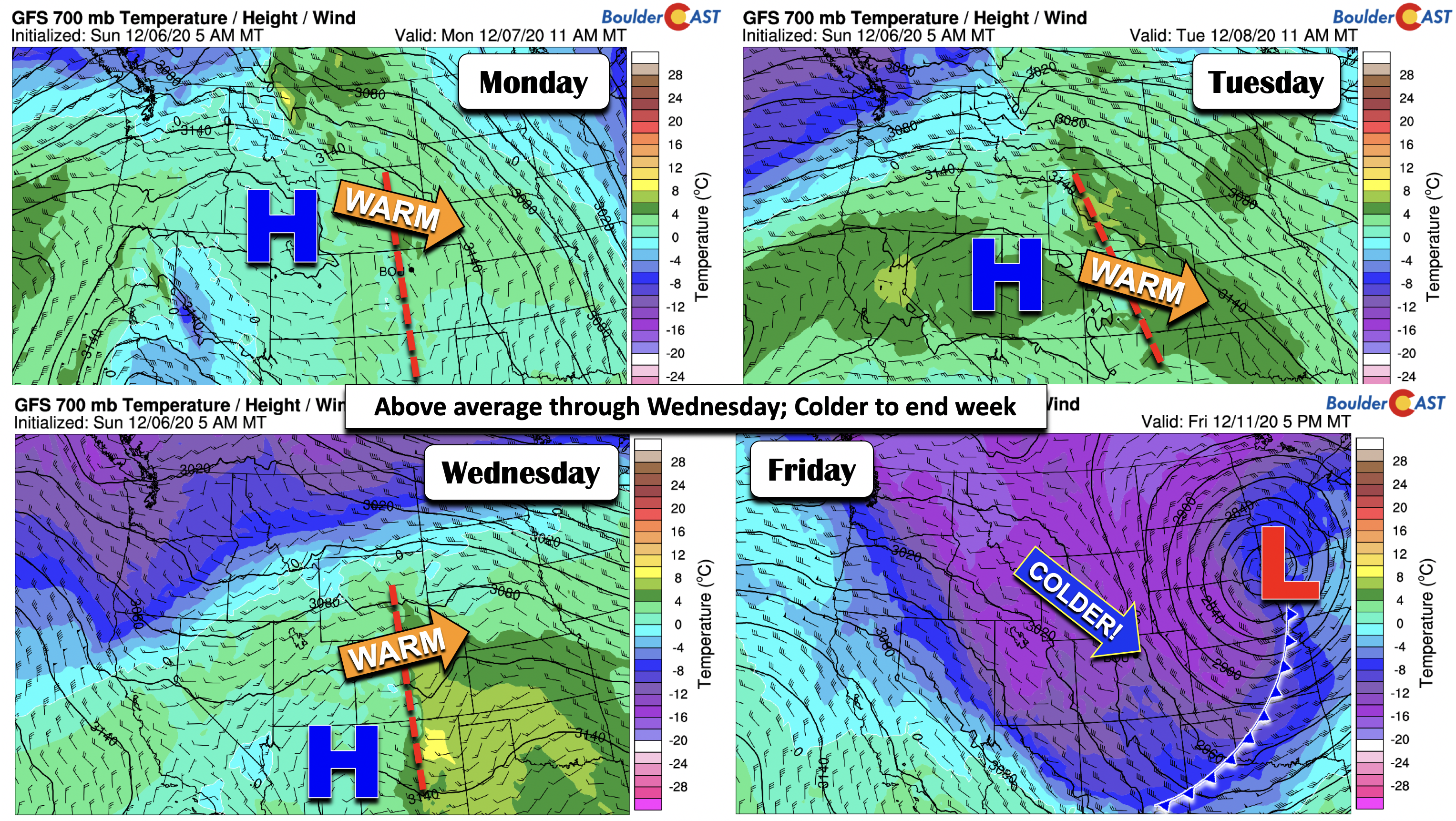
With high pressure in place through Wednesday, sunny skies will persist to start. Clouds will increase late Wednesday through Friday as a trough builds into the western United States. As for temperatures, we’ll start out near the 60-degree mark today. The low-level airmass continues to warm tomorrow (top right figure below) and Wednesday (bottom left figure below) under downslope flow. This should place us near the lower 60’s Tuesday to middle 60’s on Wednesday. Although there is uncertainty in the late-week storm, it will nevertheless turn colder thanks to strong cold air advection (bottom right figure below). Expect highs in the 30’s to end the work week.
More seasonal and colder late-week w/ a chance of snow
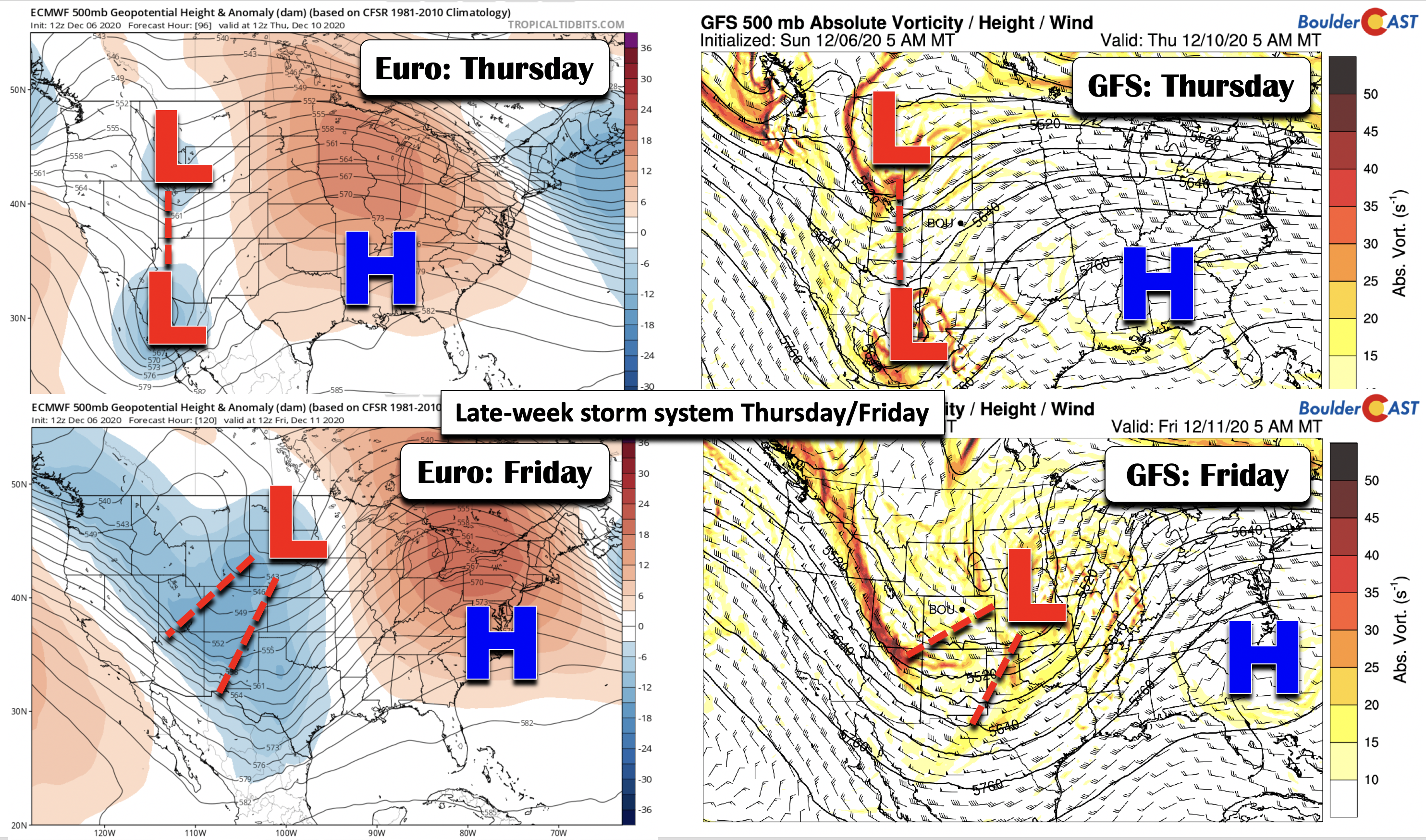
As mentioned briefly in the prior discussion, we’ll see a colder trend by week’s end. This is largely due to the model forecast guidance showing decent agreement that a trough of low pressure will form over the western U.S. and track across Colorado into the Great Plains and Midwest. The ECMWF (bottom left panels) and GFS (bottom right panels) are in decent agreement of two low pressure systems, one over Montana/Wyoming and a second over Baja California/Arizona come Thursday. By Friday, the two forecast models differ in the passage of the trough, with the ECMWF over the Dakotas and the GFS placing it near central Nebraska. Both solutions are not very favorable for snow on the Plains due to a component of downslope winds. The GFS solution, though, would favor northwest winds over Colorado, allowing for snow in the High Country and gusty winds in Denver by Friday.
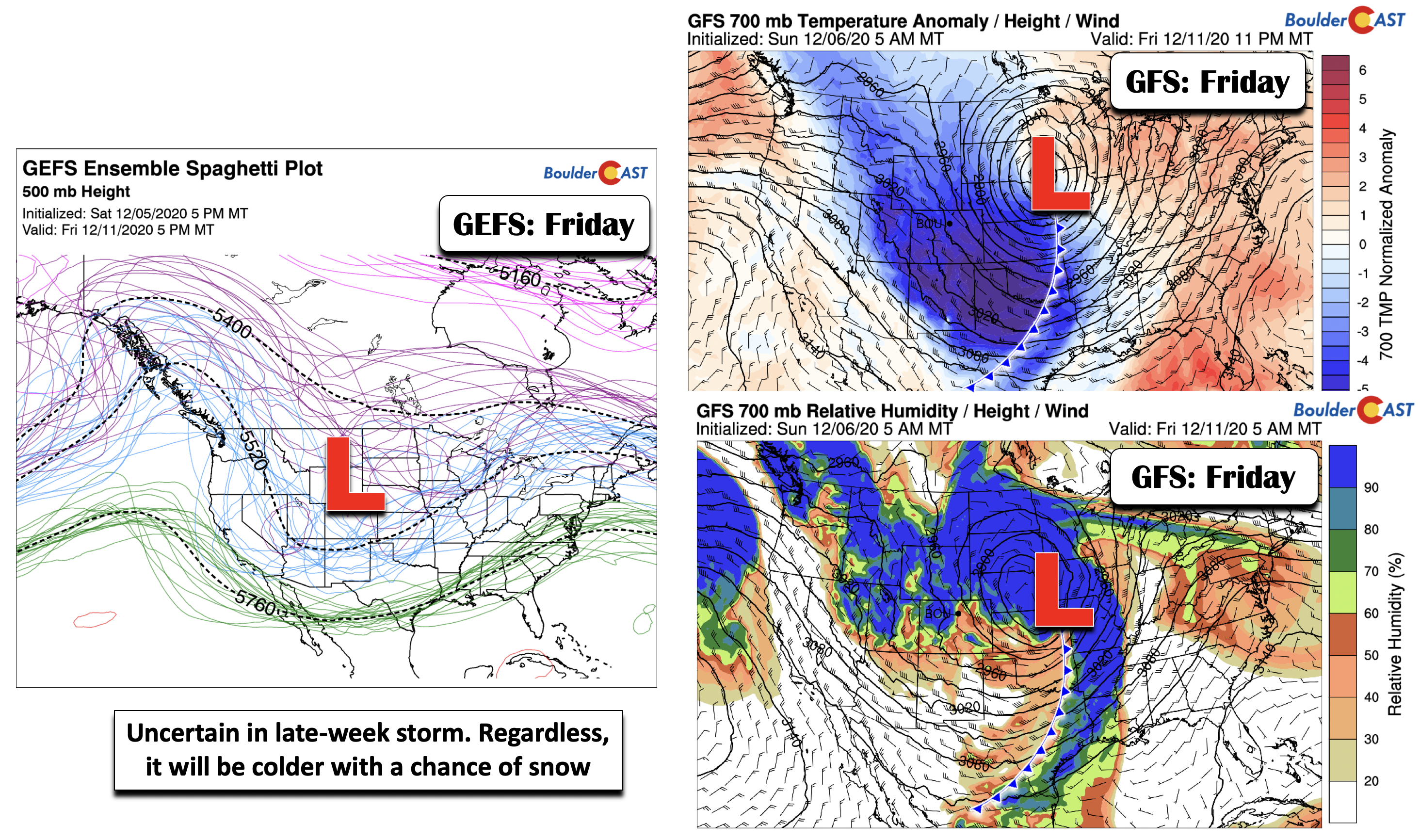
Not surprisingly, another forecast model, the Canadian model, places the trough near the Four Corners area, a more favorable placement for snow. Thus, this is something we will have to watch for week’s end. Another aspect will be whether the northern trough in Wyoming phases or merges with the cut-off low pressure system in southern California. If we take a look at the GEFS ensemble of 500-mb height patterns (bottom left), the average height pattern shows the trough over Colorado. The bottom right panels are the GFS, showing the differences between the ensemble and the GFS deterministic guidance. As you can see in the GFS forecast, the main forcing for precipitation will be well north and east of Denver/Boulder as relative humidity is highest over Nebraska (bottom right panel) and upslope better in Wyoming. Again, there is lots of uncertainty here.
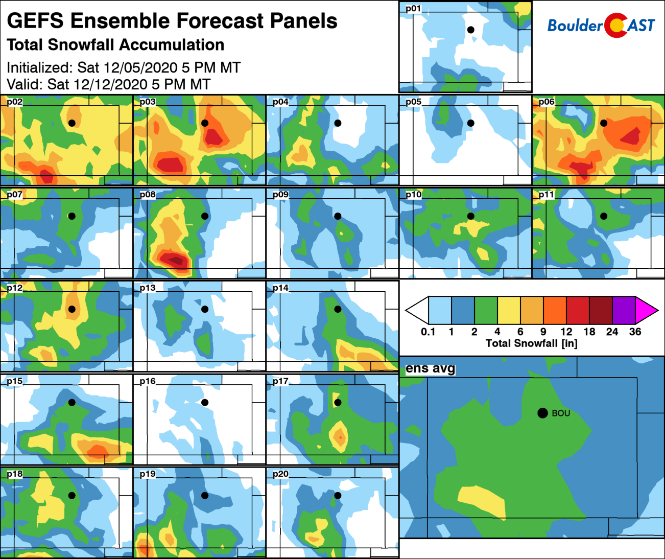
The GEFS ensemble total snowfall forecast through Saturday, for all individual ensemble members and the ensemble average, shows the snow potential quite clearly. The ensemble average places roughly 2-4″ across the Front Range. We would have to be fairly confident this far out to forecast a snow amount, which we are not…yet. At this juncture, our forecast calls for snow chances late Thursday/Friday with temperatures tumbling back into the 30’s. Keep it here in BoulderCAST for updates as we get closer.
Have a good week!
Forecast Specifics:
Monday: Sunny, mild and beautiful with highs near 60 on the Plains and near 50 in the Foothills.
Tuesday: Warmer and sunny with lower to middle 60’s on the Plains and lower 50’s in the Foothills.
Wednesday: Mostly sunny with increasing clouds late in the day. Highs in the middle 60’s for the Plains and lower 50’s in the Foothills.
Thursday: Mostly cloudy skies and more seasonal with highs in the mid to upper 40’s for the Plains and lower 40’s in the Foothills. A chance of snow exists Thursday night.
Friday: Cloudy early with a chance of snow. Skies may clear at some point during the day.Temperatures in the middle 30’s on the Plains and lower 20’s in the Foothills.
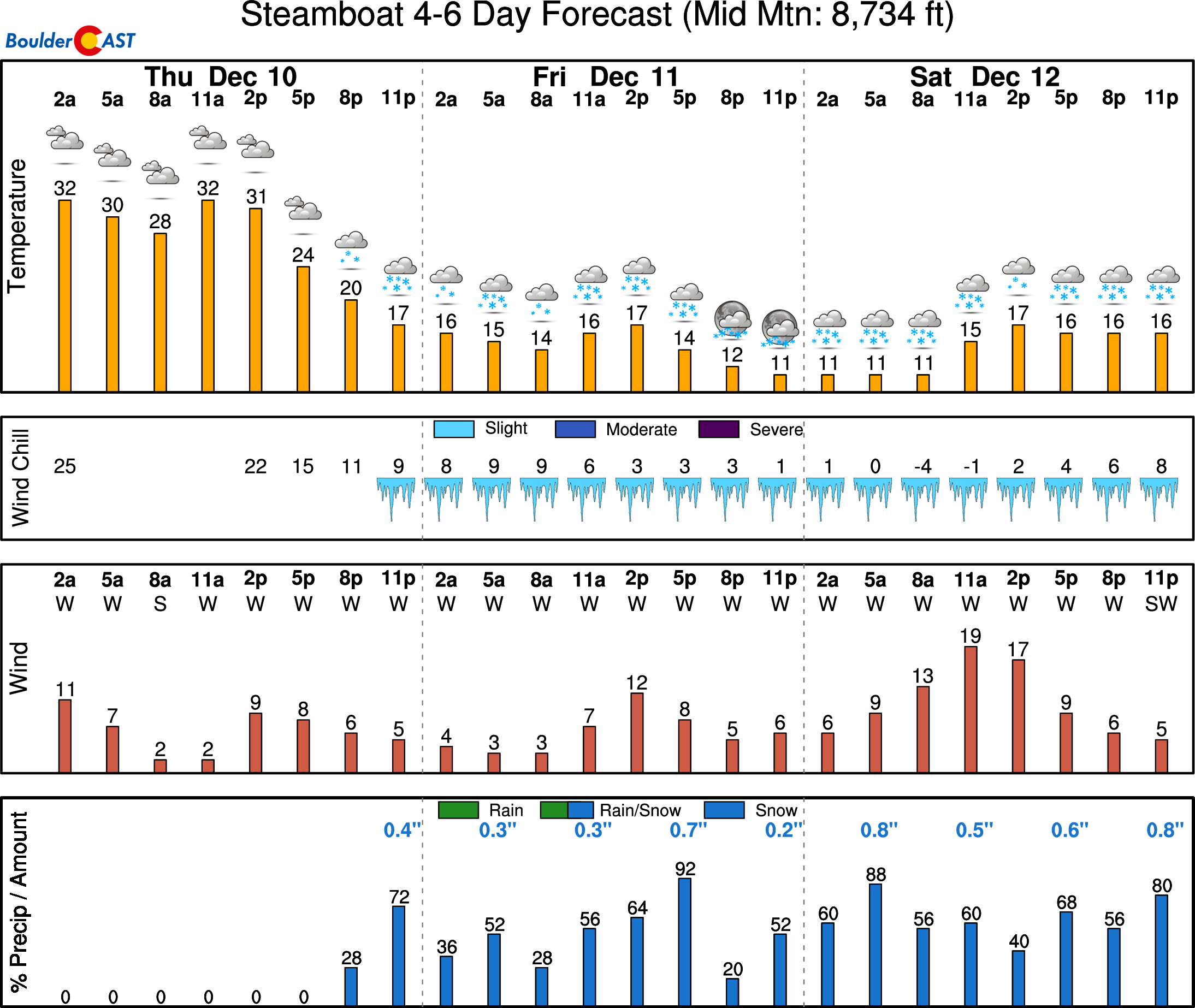
Mountains: Quiet weather persists in the High Country through Wednesday. A chance of snow develops Thursday and Friday, along with colder and windy conditions. Find daily updated forecasts for all the Colorado ski resorts over at our PowderCAST page.
Help support our team of Front Range weather bloggers by joining BoulderCAST Premium. We talk Boulder and Denver weather every single day. Sign up now to get access to our daily forecast discussions each morning, complete six-day skiing and hiking forecasts powered by machine learning, first-class access to all our Colorado-centric high-resolution weather graphics, bonus storm updates and much more! Or not, we just appreciate your readership!
.
Spread the word, share the BoulderCAST forecast!
.





You must be logged in to post a comment.