
A strong and slow-moving winter storm takes aim on Colorado late Monday night and through Tuesday. The system will bring snowfall, gusty winds, and colder temperatures to the Front Range. The greatest impacts will be felt east of the Denver Metro where blizzard conditions will exist over northeast Colorado. After a mild day to start our week on Monday, below normal temperatures in the 30s will persist through the rest of the week, with perhaps an intrusion of Arctic air in the extended outlook. Read on for the latest on potential snowfall amounts and a look at just how cold it will get this week.
This week’s highlights include:
- A strong winter storm will track across eastern Colorado late Monday night through Tuesday
- The system will bring widespread snow across the High Country, Plains, and eastern Colorado
- The greatest impacts in regards to snow totals will be felt east and northeast of the Denver/Boulder area
- Blizzard conditions in northeast Colorado Tuesday but only light snow accumulations and lesser winds around Denver/Boulder
- After highs in the 50s Monday, temperatures plummet below normal in the 30s for highs the remainder of the week
- A blocking pattern at the mid-levels will prevent the system from moving out that fast, while also setting up a potential Arctic intrusion late in the week/weekend
DISCLAIMER: This weekly outlook forecast is created Monday morning and covers the entire upcoming week. Accuracy will decrease as the week progresses as this post is NOT updated. To receive daily updated forecasts from our team, among many other perks, subscribe to BoulderCAST Premium.

Strong winter storm takes aim on Colorado Monday night through Tuesday
If you are a premium subscriber, you have heard us talking over the last several days about a strong winter storm set to impact the state early this week — one which will largely be a swing and a miss for the Front Range. For everyone else, this may be a surprise — but hopefully not!
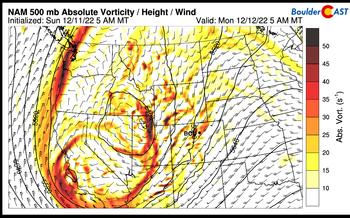
Shown below is an animation of the NAM 84-hour forecast of 500-mb heights and vorticity (rotation/energy) through Wednesday. A strong mid-level trough over the west coast and western US will close off and intensify as it crosses the Continental Divide Monday night into Tuesday. The system will track roughly from far south-central Colorado late Monday night into far eastern Colorado and western Nebraska/Kansas by Tuesday morning and afternoon. The system will be slow to move out, owing to a blocking ridge over the eastern United States. That will allow the big low to rotate counter-clockwise over the northern Great Plains through Wednesday, making its impact felt on our area through much of the week ahead. Model guidance has come into very good agreement on the track of this system, with nearly all global models (GFS, ECMWF, CMC) and regional models like the NAM showing a very consistent track and position. As such, confidence has increased on the overall impacts, or lack thereof, for our region.
Shown below is the corresponding NAM 800-mb heights, temperature, and wind through Wednesday. At this near-surface level, a strong low pressure system will develop Monday night and into Tuesday over far eastern Colorado, tracking up into north-central Kansas and Nebraska Tuesday, and eventually the northern Great Plains by Wednesday. Intense frontogenetical forcing coincident with the warm and cold conveyor belts will maximize over northeast Colorado on Tuesday, favoring heavy banded snowfall in this region. Furthermore, as we’ll discuss in a bit, strong northwest flow will favor blizzard conditions in this area as well. Let’s get on to specifics!

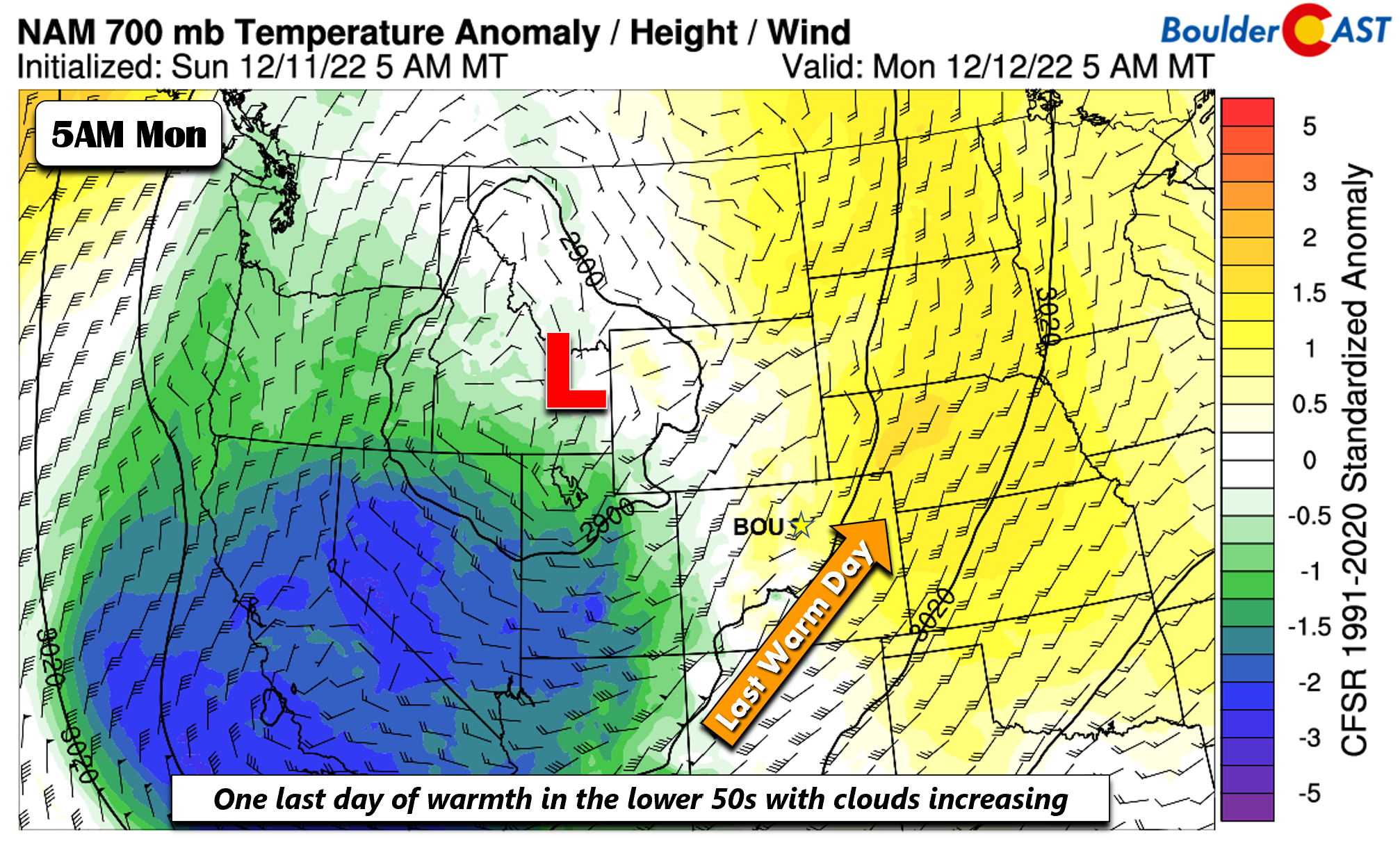
We’ll start off our Monday on the mild side once again, with temperatures likely reaching the lower 50s over the Denver Metro area. Clouds will be on the increase, however, as the day wears on, so look for sunshine giving way to a milky sky typical for an approaching snowstorm.
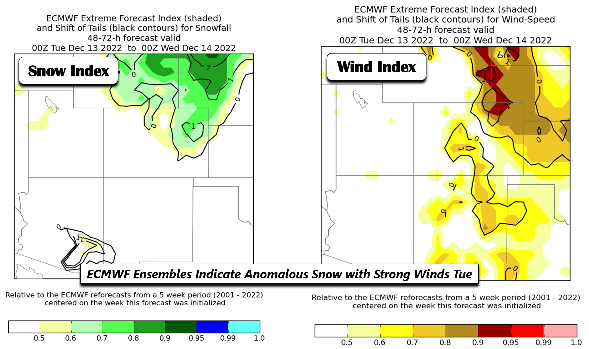
Model guidance for at least the past day or two has been pinpointing northeast Colorado being the favored spot for snow and gusty winds. The two images below are plots of the ECMWF extreme forecast index, courtesy of NOAA/NWS. The index measures the potential for an anomalous event (shading) in snowfall (left) and wind speed (right). The black contours denote if the event could be an extreme event. Shaded values in either parameter generally at/above 0.7 signify that many ECMWF ensemble members are forecasting several inches of snowfall in the highlighted region that is anomalous relative to the ensemble climatology. Shwew! Values for the contours above 2-3 would indicate an extreme event. The two images highlight the good consensus for heavy snow potential and gusty winds in northeast Colorado. The key takeaway here — this is an anomalous event but not extreme.
Here are some thoughts on the storm for the area:
- The system will track across east-northeast Colorado and Kansas Tuesday. Heavy snowfall will be felt on the north and west side of the surface low over Kansas and Colorado, favoring far northeast Colorado.
- As the low pressure system develops over eastern Colorado, there will be a brief window where flow will become northeasterly late Monday night and part of Tuesday morning, allowing brief upslope flow to favor snow for the Boulder/Denver area. Portions of eastern Denver could also get clipped on the northwest banded snowfall region for a brief period before the storm tracks east-northeast into Kansas
- Snow impacts are expected to be minimal, but noticeable for Boulder/Denver, with amounts generally between 1-3 inches. Higher amounts up to a foot are possible in northeast Colorado coincident with blizzard conditions.
- Highs in the lower 50s to start Monday will trend to temperatures plummeting into the 20s overnight along with gusty winds of 20-35 MPH Tuesday with highs in the lower 30s.
The next several sets of images will be a comparison of the model precipitation forecasts to get a sense of confidence in our forecast and for you. The first two plots are instantaneous 6-hr accumulated precipitation Tuesday morning from the CMC (top) and ECMWF (bottom). The location/track of the surface low is nearly identical between the two, with the only minor difference being the ECMWF about 3 mb stronger than the CMC. Both models place the banded snow on the northwest side of the low over east/northeast Colorado and into western Nebraska. Very little accumulation is felt over Denver/Boulder with northwest downslope flow already in place.
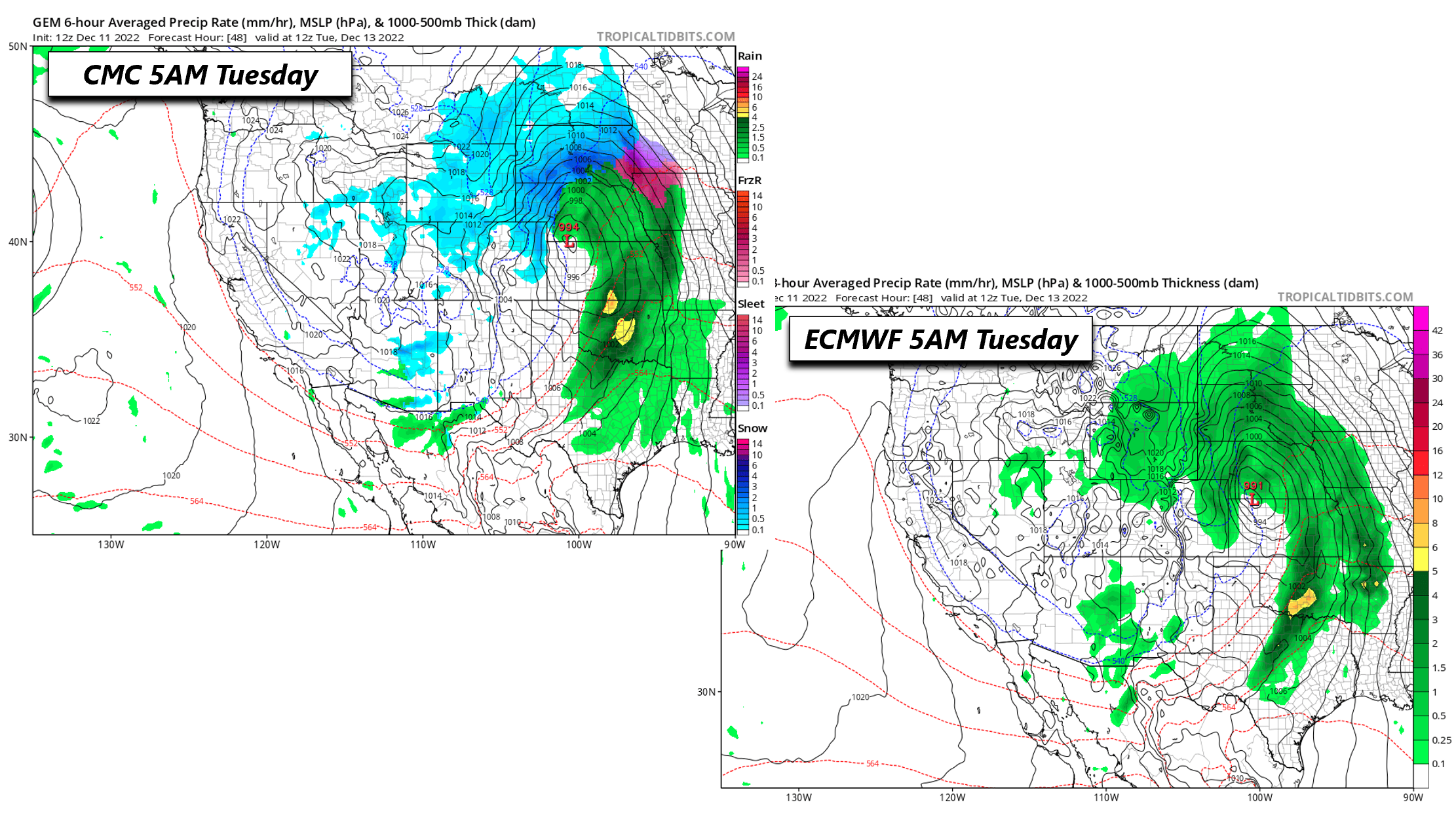
While a similar pattern is found in the GEFS (top left) and GFS (below right) to the CMC/ECMWF, the GFS/GEFS are slightly west with the heavy precipitation shield. The western edge of the shield in these models clips eastern portions of Denver, resulting in higher snowfall amounts versus the CMC/ECMWF/NAM. These differences are found even though the GFS surface low track is nearly the same as the CMC/ECMWF, though slightly slower in its speed.
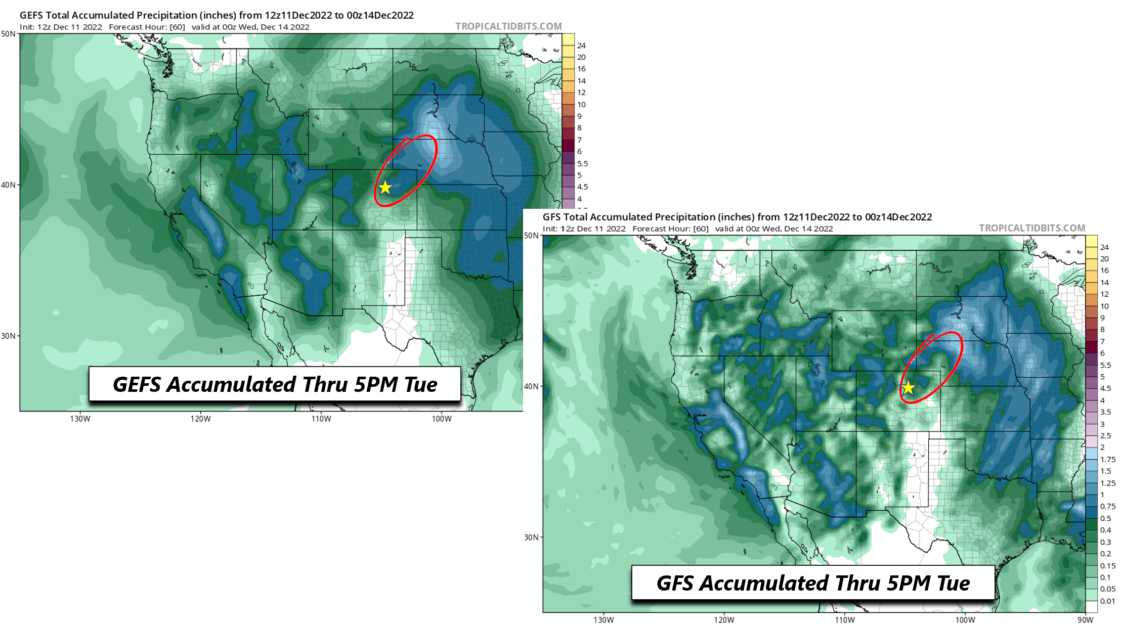
A stark contrast is more evident between the NAM (below left) and GFS (below right) for total snowfall through the event. Notice how the GFS has its snowfall band further west, stretching from Denver into Fort Morgan and Sterling. The NAM is much farther east and closer to the CMC/ECMWF and their ensembles, with the heavy snow over far eastern Colorado. The NAM dry slots the Denver/Boulder area with little if any snow.

An investigation of the GFS/GEFS synoptic fields indicates that the GFS exhibits a slightly stronger upslope component as the surface low develops over eastern Colorado, whereas the other 3 models (ECMWF shown below as example) are more northerly to northwesterly and thus exhibit less upslope and more downslope.
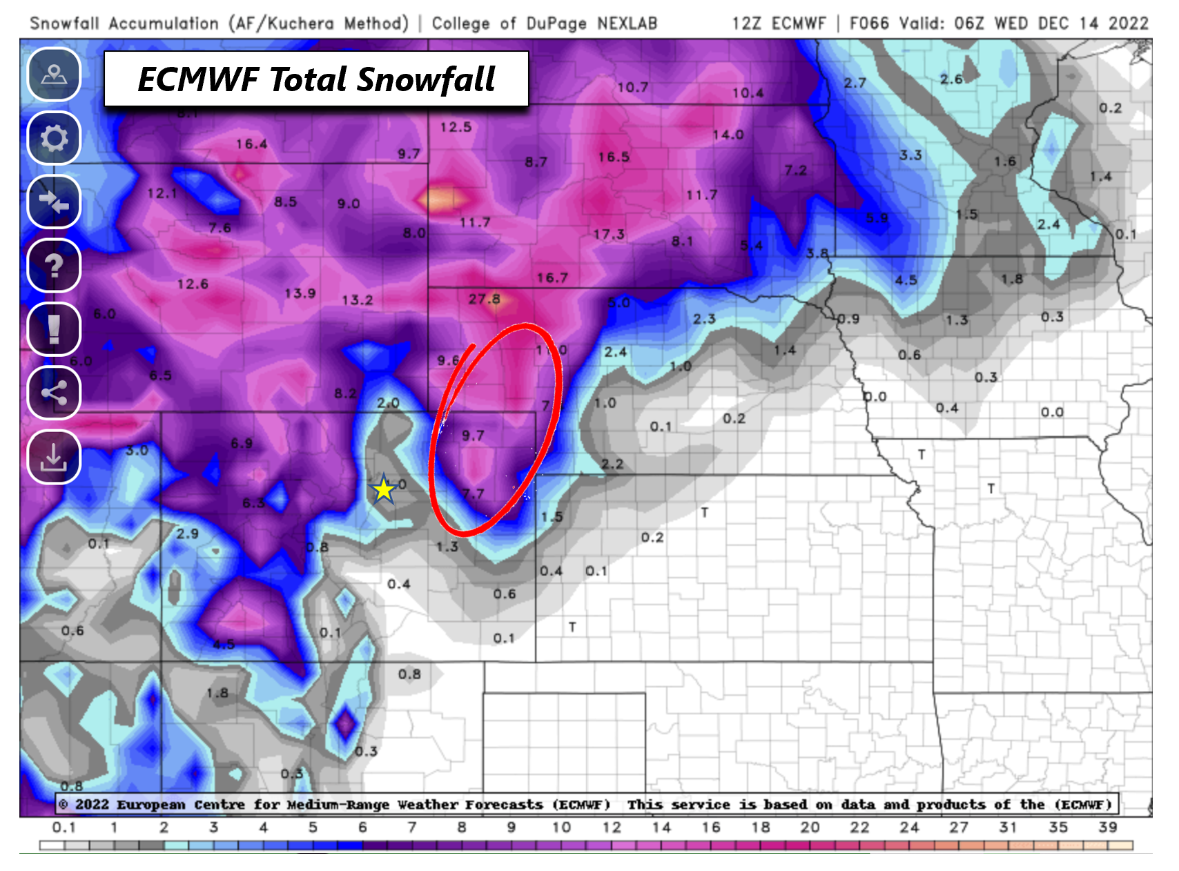
Lastly, let’s look at GEFS snowfall probabilities, keeping in mind the GEFS is somewhat biased west with the heavy snowfall versus the other guidance. With that said, the probabilities for Boulder favor snow totals in the 1-2 inch range at a maximum, whereas for Denver it would favor 2-3 inches at most. The one exception is near the airport, where the bias of the westward GEFS is most evident. The probabilities indicate potential for 3-6+ inches. All things considered, unless the track of the storm changes drastically in the latest updates today, the consensus would favor generally 0-3 inches in Boulder/Denver. However, given the strong downslope flow and the track of the surface low, pattern recognition would mean a higher probability for the lower end amounts in that said range.

The best time period for accumulating snowfall will be late Monday night and overnight and into the early morning hours Tuesday, when the northwest side of the low will clip Denver and brief upslope will be felt in Boulder. After that, downslope flow, cold temps, and gusty winds will prevail, at times creating some drifting snow. We cannot, however, rule out some pockets of 4 inches in eastern Denver and near DIA, especially if the system wraps up further west than anticipated. With that said, our confidence in this is low at the moment, unless things change. Our snowfall forecast map for the event is shown below covering all snow through Tuesday evening (updated 12/12/22 6AM):

This storm will also do work in the Mountains with several ski resorts set to pick up over a foot of snow.

Below normal temperatures through the remainder of the week…late-week arctic surge??
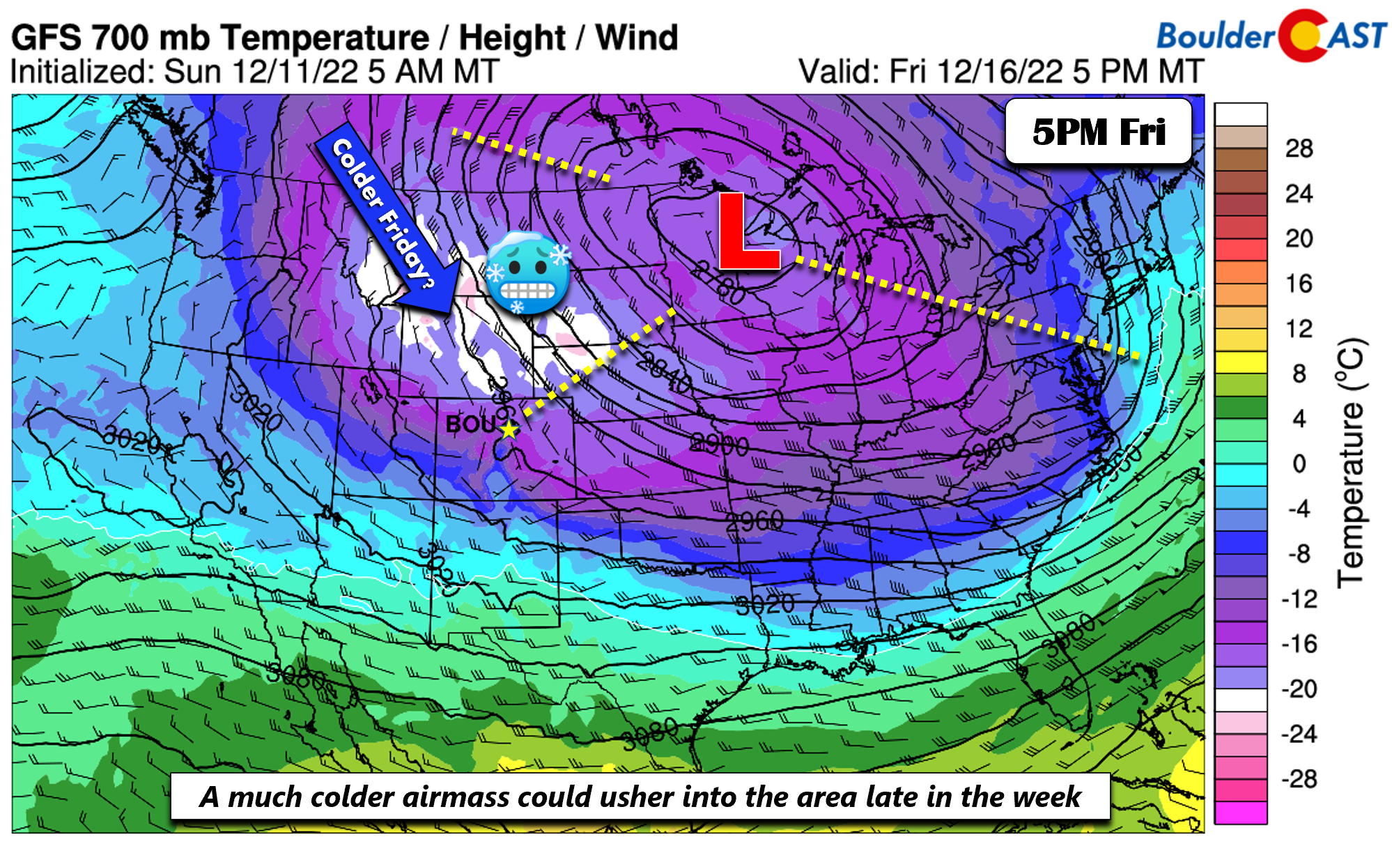
While the snow and wind impacts will exit late Tuesday, the storm system will be slow to fully move out. A blocking pattern will be in place with a ridge over the northeast US, as well as an offshore low pressure system in the North Atlantic Ocean. These two features will prevent the storm from pushing east as fast. The result will be a cold weather pattern through the remainder of the week, as our area stays in that chilly/breezy northwest flow. By Thursday, the system will be over central Iowa. Ridging will also be located over the Pacific Northwest and into Alaska.

With the ridge near Alaska and western Canada and the closed low over the upper Mississippi Valley stuck in place, the pattern will favor a possible Arctic intrusion by week’s end and into the weekend. The combined northerly flow over Montana from this synoptic setup is ideal for allowing a northerly flow directly from the polar region and Canada into Colorado. This pattern is all a result of a weakening Arctic polar vortex in the stratosphere. The GFS/CMC and, to a lesser degree, the ECMWF, show this potential come Friday and Saturday. However, there still remains considerable spread in the guidance given the highly amplified flow. As such, it is unclear at the moment if the coldest air will reach us or stay over the northern Great Plains. Time will tell so stay tuned. A ripple of energy could also stream down to bring another chance of light snow late in the week, but uncertainty abounds on this facet as well. Given that, we are forecasting a dry rest of the week for now. Temperatures will stay in the 30s but could be much lower if that Arctic intrusion manifests.
If you missed our very cold and snowy November recap post, be sure to check that our by following the link below. Have a great week and stay warm!
Forecast Specifics:
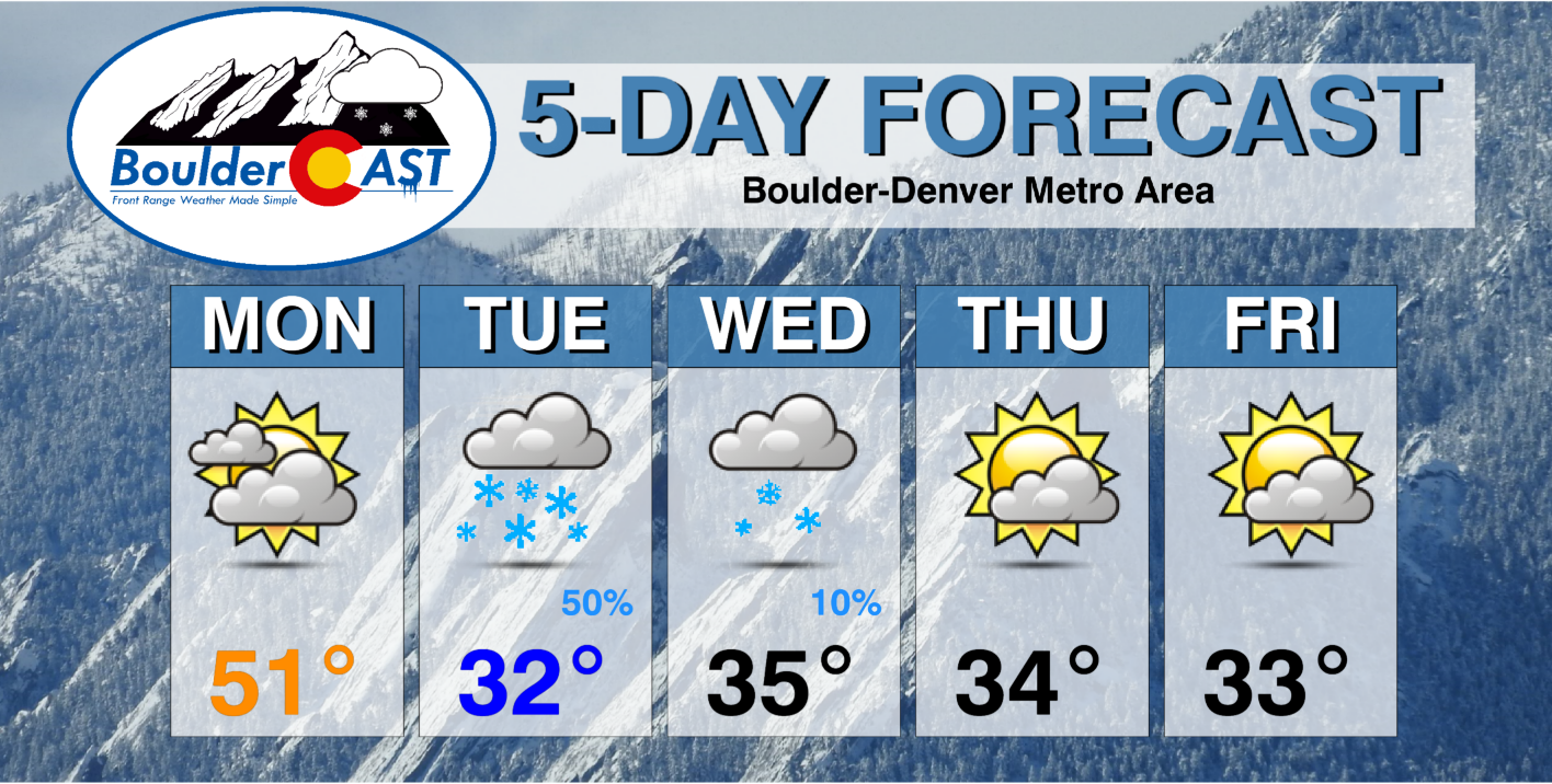
Monday: Highs in the lower 50s on the Plains and lower 40s in the Foothills to start the day. Increasing clouds will move in this afternoon, and light snow will develop late in the evening with temperatures dropping into the 20s.
Tuesday: Light snow in the early morning, then becoming blustery with highs in the lower 30s on the Plains and middle 20s in the Foothills. Northwest winds could gust between 25-35 mph at times, causing drifting snow. Light snow may linger, especially east of Denver. Snow totals to range from 1 to 4 inches, highest near Denver International Airport.
Wednesday: Mostly cloudy and chilly with highs in the low/middle 30s on the Plains and middle 20s in the Foothills with gusty winds at times. There could be a few lingering flurries, especially east of Denver.
Thursday: Partly sunny and chilly with low to middle 30s on the Plains and middle 20s in the Foothills.
Friday: Partly sunny and chilly with lower/middle 30s on the Plains and middle 20s in the Foothills.
High Country: Widespread snow will develop across the High Country Monday evening through early Wednesday as west-northwest upslope flow will linger along/west of the Divide. This will favor over a foot of snow in many locations and ski resorts. The highest amounts will be felt over northwest facing slopes over northwest Colorado, in places like Steamboat. Gusty winds will be felt much of the week. Calmer weather but still cold weather will take over Thursday and Friday.
Help support our team of Front Range weather forecasters by joining BoulderCAST Premium. We talk Boulder and Denver weather every single day. Sign up now to get access to our daily forecast discussion email each morning, complete six-day skiing and hiking forecasts powered by machine learning, first-class access to all our Colorado-centric high-resolution weather graphics, bonus storm updates and much more! Or not, we just appreciate your readership!
Spread the word, share the BoulderCAST forecast!


You must be logged in to post a comment.