Following a chilly and unsettled first week of April, this week will be much quieter across Colorado with generally warm and dry conditions favored throughout the entire week under the protection of high pressure. Temperatures will fluctuate a tad due to a pair of dry backdoor cold fronts, but otherwise this week will offer-up gorgeous spring weather. That theme will continue right into the upcoming weekend with the first 80-degree temperatures of the year likely. Read on for all the details.
This week’s highlights include:
- Protective Ridge: Colorado will remain under the protection of a strengthening ridge of high pressure the entire week, with little to no weather to speak of
- No Precipitation: The week will be totally dry across the Front Range, with our next chance of rain not coming until Sunday or early next week
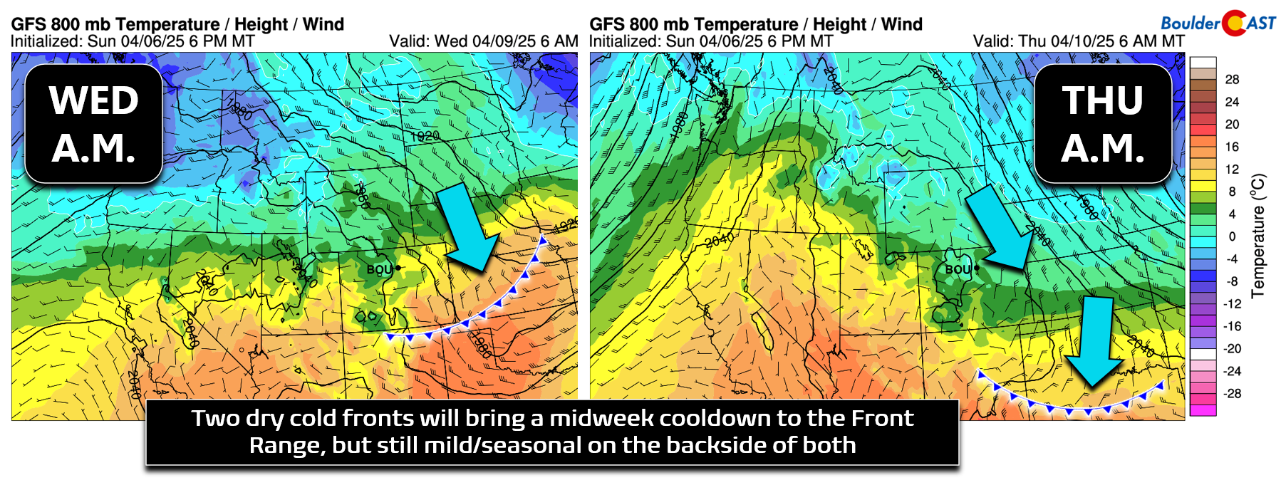
- Mid-Week Cold Fronts: Two weak (and dry) cold fronts will move through the area bringing slightly cooler temperatures for Wednesday and Thursday
- Heating Up for the Weekend: Temperatures really warm by Friday and Saturday with the first 80-degree afternoon of 2025 likely to unfold one or both days
DISCLAIMER: This weekly outlook forecast is created Monday morning and covers the entire upcoming week. Accuracy will decrease as the week progresses as this post is NOT updated. To receive daily updated forecasts from our team, among many other perks, subscribe to BoulderCAST Premium.

Go Premium, get all the perks.
Daily Forecast Updates
Get our daily forecast discussion every morning delivered to your inbox.
All Our Model Data
Access to all our Colorado-centric high-resolution weather model graphics. Seriously — every one!
Ski & Hiking Forecasts
6-day forecasts for all the Colorado ski resorts, plus more than 120 hiking trails, including every 14er.
Smoke Forecasts
Wildfire smoke concentration predictions up to 72 hours into the future.
Exclusive Content
Weekend outlooks every Thursday, bonus storm updates, historical data and much more!
No Advertisements
Enjoy ad-free viewing on the entire site.
Warm & dry all week long
The primary influence on our weather this week will be a developing ridge of high pressure across the southwestern United States which will eventually sharply intensify over Colorado in a few days’ time. As shown in the Euro models’s 500mb height anomaly forecast animation below, Colorado will remain squarely within this ridge, at varying levels of intensity, through the entire week into the weekend ahead.
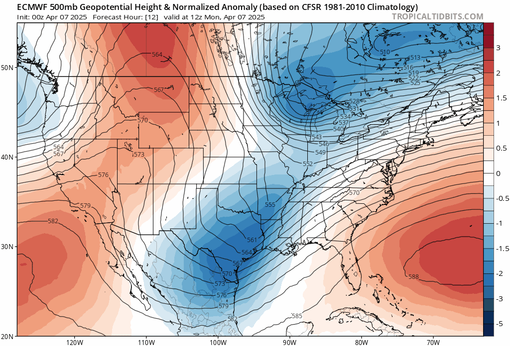
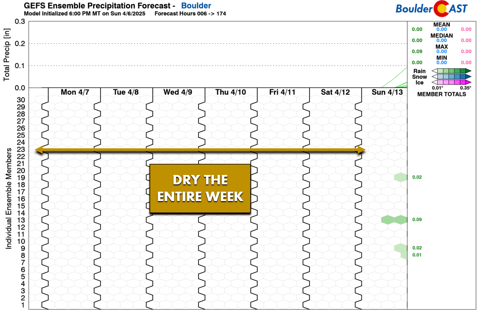
Underneath this ridge, we’re not expecting any precipitation to fall this week across the Boulder-Denver area, with completely dry conditions through at least Saturday. A chance of rain or thunderstorms should return to the forecast by Sunday or early next week, but between now and then we have at least six more entirely dry days ahead.
The only minor forecast highlights this week will come in the form of two backdoor cold fronts — both tied to disturbances passing well north of our area along the Canadian Border. One weak front will move through Tuesday evening/night, with a secondary slightly cooler front sliding through Wednesday night. These fronts will bring cooler temperatures for Wednesday and Thursday, but will not offer any precipitation chances thanks to a lack of moisture and downslope flow.
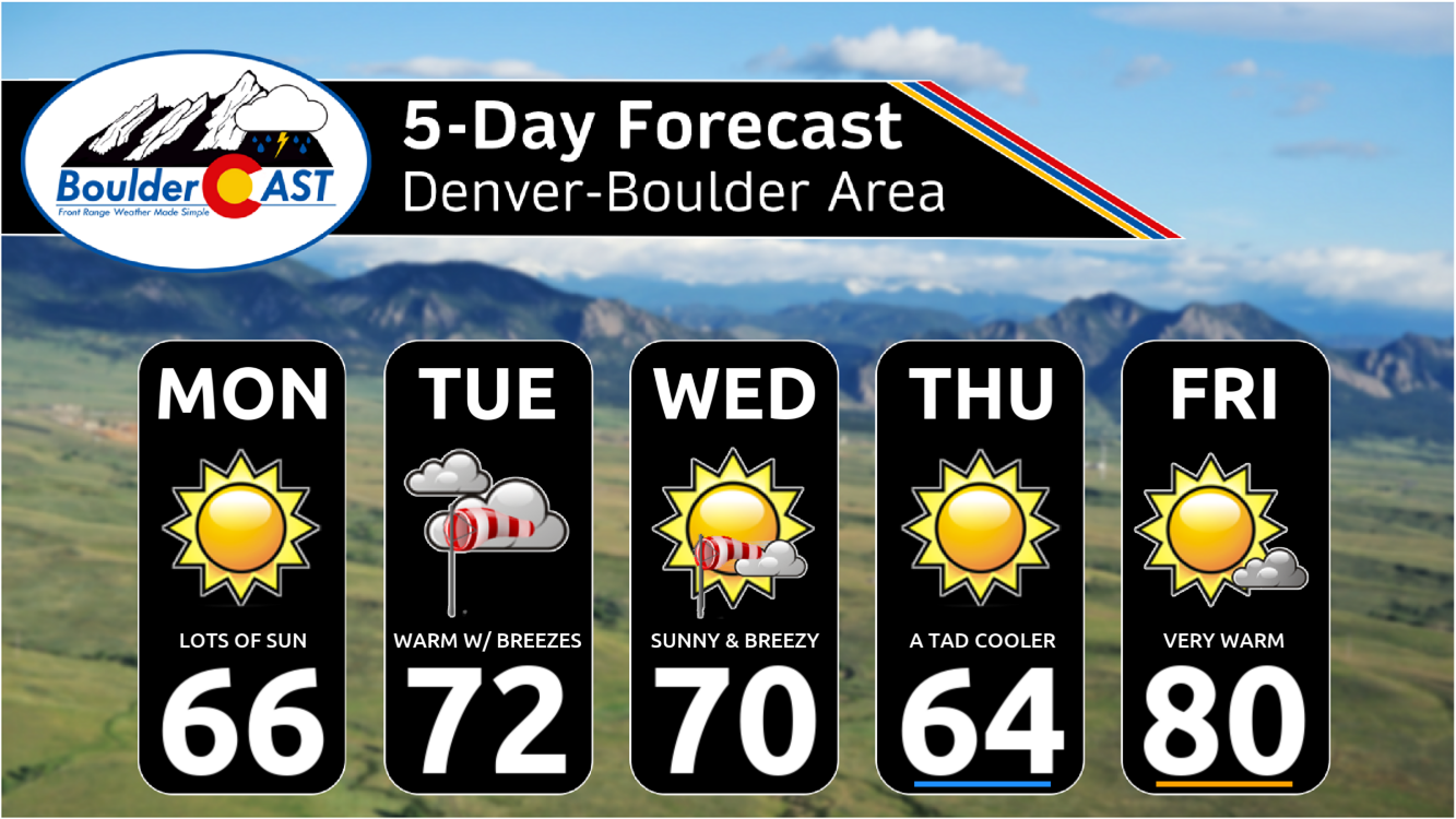
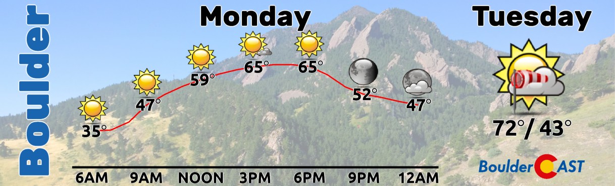
We kick off the week in the 60s on Monday with sunshine, with temperatures warming further into the lower 70s on Tuesday with more clouds around and downslope breezes.
The mid-week period will be slightly cooler following the passage of the two cold fronts, but temperatures will remain near or above normal both days in spite of the fronts. We’re expecting highs close to 70° on Wednesday with breezy conditions and spotty wave clouds. Cooler readings in the 60s will follow on Thursday but with full sunshine. We end the week very warm and quiet with highs reaching the lower 80s Friday into Saturday. Enjoy!
Forecast Specifics:
Monday: Sunny and mild with highs reaching the middle 60s on the Plains with lower 50s in the Foothills.
Tuesday: Partly to mostly cloudy, warm and breezy at times. Highs push into the lower 70s on the Plains with upper 50s in the Foothills.
Wednesday: Mild, dry and breezy with just a few wave clouds around. Temperatures top out around 70 degrees on the Plains with upper 50s in the Foothills.
Thursday: Slightly cooler following an overnight dry cold front, but lots of sunshine. Expect highs in the middle 60s on the Plains with lower 50s in the Foothills.
Friday: Very warm and dry with mostly sunny skies. High temperatures will soar towards 80 degrees on the Plains with upper 60s in the Foothills.
Weekend: Staying warm in the 80s on Saturday, but another cold front will reach the area on Sunday with readings falling into the 70s. There could be a spotty thundershower Sunday across the area, but for now moisture looks limited so the chance will be low.
Get BoulderCAST updates delivered to your inbox:
DISCLAIMER: This weekly outlook forecast is created Monday morning and covers the entire upcoming week. Accuracy will decrease as the week progresses as this post is NOT updated. To receive daily updated forecasts from our team, among many other perks, subscribe to BoulderCAST Premium.
Go Premium, get all the perks.
Daily Forecast Updates
Get our daily forecast discussion every morning delivered to your inbox.
All Our Model Data
Access to all our Colorado-centric high-resolution weather model graphics. Seriously — every one!
Ski & Hiking Forecasts
6-day forecasts for all the Colorado ski resorts, plus more than 120 hiking trails, including every 14er.
Smoke Forecasts
Wildfire smoke concentration predictions up to 72 hours into the future.
Exclusive Content
Weekend outlooks every Thursday, bonus storm updates, historical data and much more!
No Advertisements
Enjoy ad-free viewing on the entire site.
Enjoy our content? Give it a share!


You must be logged in to post a comment.