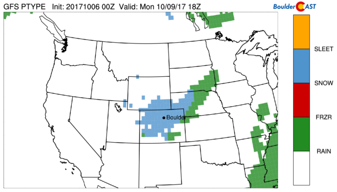
Things are about to turn white across the region as a quick-hitting storm brings freezing temperatures and snow to the Front Range. Read on for details.
Tag: snow (Page 7 of 21)
The storm track has officially returned southward to Colorado! The first full-week of October will feature a swing in temperatures, starting off on the cold and wet side for your Monday. Meanwhile, the first dumping of snow in the Mountains and Foothills started yesterday and continues today. Read on for our complete outlook.
We’ve really been spoiled of late in regards to weather! Only a few raindrops have fallen in the last six weeks, with temperatures remaining warmer than normal on all but a handful of days. This changes on Saturday as a deep trough plows into the region, kicking the unending ridge of high pressure eastward. Cool and unsettled weather will linger well into next week. We’re also monitoring the potential for the first significant snowfall in the Mountains. We have a lot to discuss!
Thanks to everyone who entered our “First Snow” contest. We briefly review the entries, which surprisingly follow closely with Boulder’s climatology of late October.
This week’s weather will fail to outdo last week’s historic snow storm, but nonetheless the pattern remains active across Colorado. The week starts off with a cold frontal passage Monday evening, followed by at least one nice day under the influence of high pressure. Storm activity under southwest flow returns towards the end of the week, though. We also cover the forecast for the upcoming holiday weekend and the BolderBoulder. Continue reading for the details.
More unsettled weather is looming for the week ahead! We’ll squeeze out a few nice days to start, but temperatures will be tumbling by mid week as a formidable storm system heads towards Colorado. Thursday and Friday’s forecast is currently shrouded in a bit of uncertainty, by several models are indicating significant precipitation for the Front Range, and even the potential for accumulating snow across the Plains. Read on for all the details.
As we have been relaying to you all week, another spring snow storm is on the way this evening and will linger into Saturday afternoon. Read on as we detail our final thoughts on the storm and snow amounts for the Foothills and Plains.
Another storm is on the way! These late-season spring systems are almost always a messy forecast with a high potential to bust. The upcoming storm will NOT be an exception to this general rule. We detail the set-up for the storm and provide some initial thoughts and expectations for rain and snow set to begin Friday afternoon and continue into Saturday.
© 2026 Front Range Weather, LLC


