Though MLK Day will begin rather mild and pleasant, a storm is heading this way! Rain and snow showers will develop later this evening across the Front Range and continue overnight into early Tuesday. We discuss the timeline for the storm, potential snow amounts, and where blizzard conditions will be possible Monday night.
PREMIUM STORM UPDATE (Monday Jan 21 at 3:00 PM): A quick check on the latest models runs and what it means for the forecast. Read HERE.
Just like one year ago, here we are talking snow on MLK Day! We’ve been discussing the likelihood of accumulating snow tonight for a while now with our Premium members. There should be no surprises here for you…
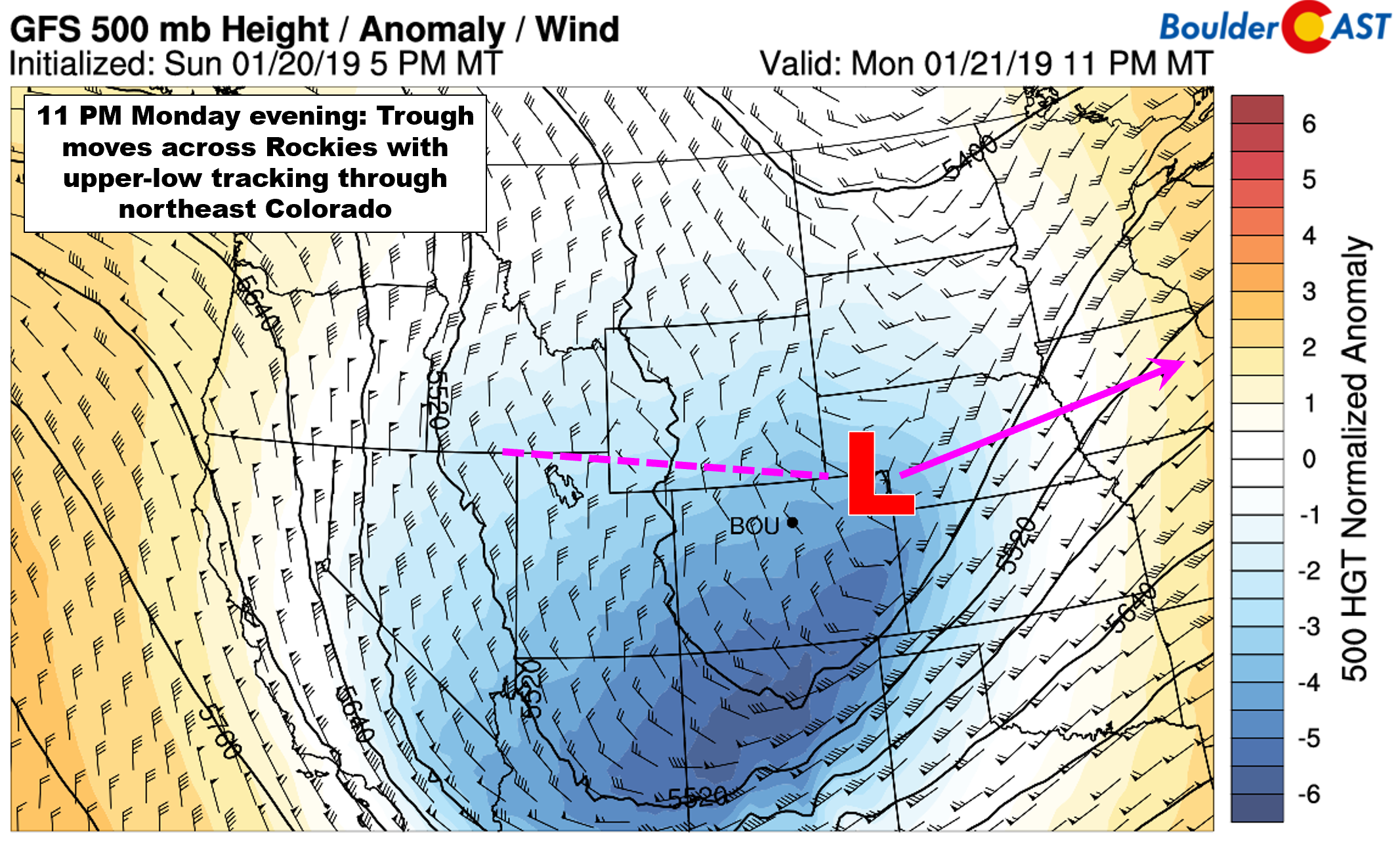
In terms of the large-scale set-up, the models are in good agreement that trough will drop out of the Pacific Northwest and slide eastward over the next twelve hours into Colorado. Below shows the mid-level height forecast from the GFS this evening. We caution that some lingering disagreement remains in the exact track of the 500 mb low pressure center. Will it remain further north near the Nebraska border, as the GFS & NAM are suggesting? Or will it dig slightly further south, closer to I-70 near the Kansas line? This is what the Euro is predicting. Nonetheless, neither set-up is all that favorable for much snow around Denver or Boulder. It’s more a question of how much snow is possible east of Denver towards Kansas, and how widespread blizzard conditions may be tonight in these locations.
Let’s not get ahead of ourselves, though. Highs Monday will be similar or slightly warmer than Sunday in the middle 50’s across the Denver Metro area. The warm airmass prior to the cold front moving through tonight is not all that different from the past 24 hours. We’ll see a fair amount of sunshine to start, with increasing clouds through the afternoon and evening with precipitation beginning to develop in northern Colorado after sundown.
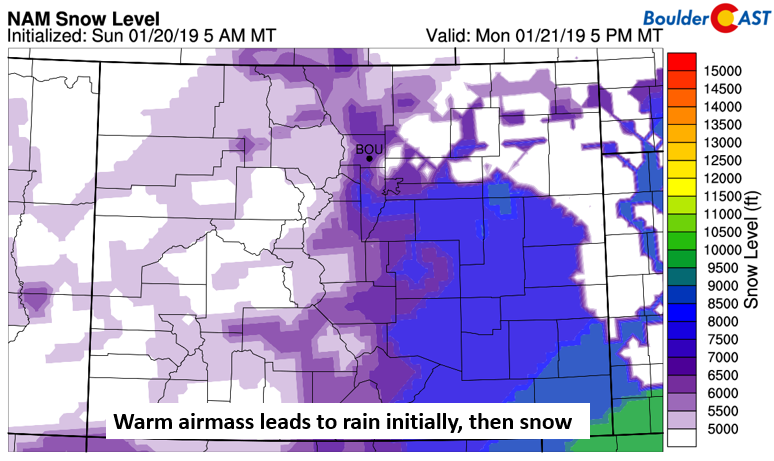
Due to the warm airmass, initially the precipitation type will likely be rain or a rain/snow mix for the lower elevations. Our snow level product using NAM model data pins the snow level around 6000 feet elevation at the onset. However, the cold air advancing south and dynamic cooling should quickly change the precipitation type over to snow before midnight.
Once again, the wind direction in the low to mid-levels of the atmosphere is our primary concern with this passing storm. Regardless of the eventual track of the upper-level disturbance, upslope in the Front Range will be minimal at best. The NAM and GFS models largely agree, though small differences are apparent, which will of course play into the snowfall potential east of the Mountains.
The 700 mb wind forecast is shown below for 11 PM tonight and 5 AM Tuesday morning. This level is approximately at 10,000 feet elevation. The forecast shows a strong north-south oriented jet of 50 to 70 mph from Wyoming into south Denver, parallel to the Foothills. This pattern persists much of the overnight hours. The GFS and Euro (not shown) have a slightly more north-northeasterly wind direction. These small differences lead to virtually no upslope in the NAM, and weak upslope in the GFS and Euro. While wind speeds in this jet are very impressive, the component of upslope (easterly) is not. All in all, just like most storms of late, this snow event won’t be a major one for the Front Range either.
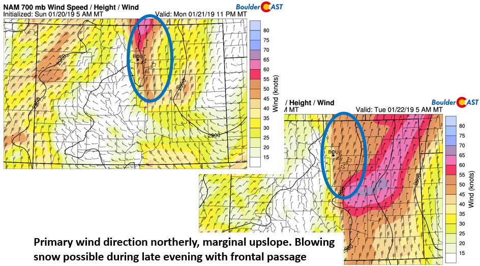
NAM 700 mb wind for 11 PM tonight (left) and 5 AM tomorrow (right)
The differences are most apparent in the snowfall forecast from the NAM (below), which has virtually nothing in Boulder and northwest Denver, 1-3″ in downtown Denver, and even more further southeast. This is because the NAM has a stronger downslope component, with sinking air over Boulder County from the northerly winds.

NAM snowfall forecast
The GFS forecast is more subtle with the drying (red circle). It has amounts of 1-4″ in Boulder and Denver, but less than 1″ in Longmont and Fort Collins.
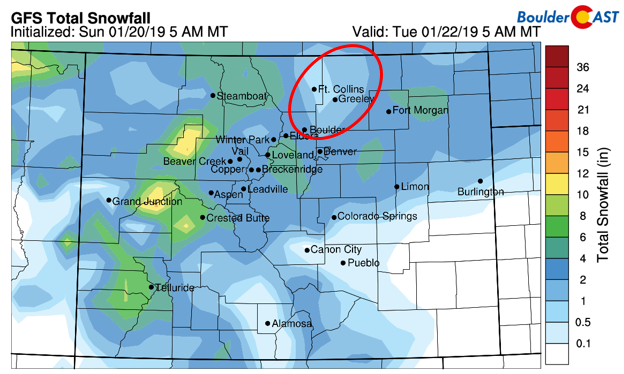
GFS snowfall forecast
The GFS ensembles are in agreement with the operational GFS, hinting at 1-4″ across the Denver/Boulder area. However, some of the GFS ensemble members, as evident below, show the same drying as indicated by the NAM north of Denver.
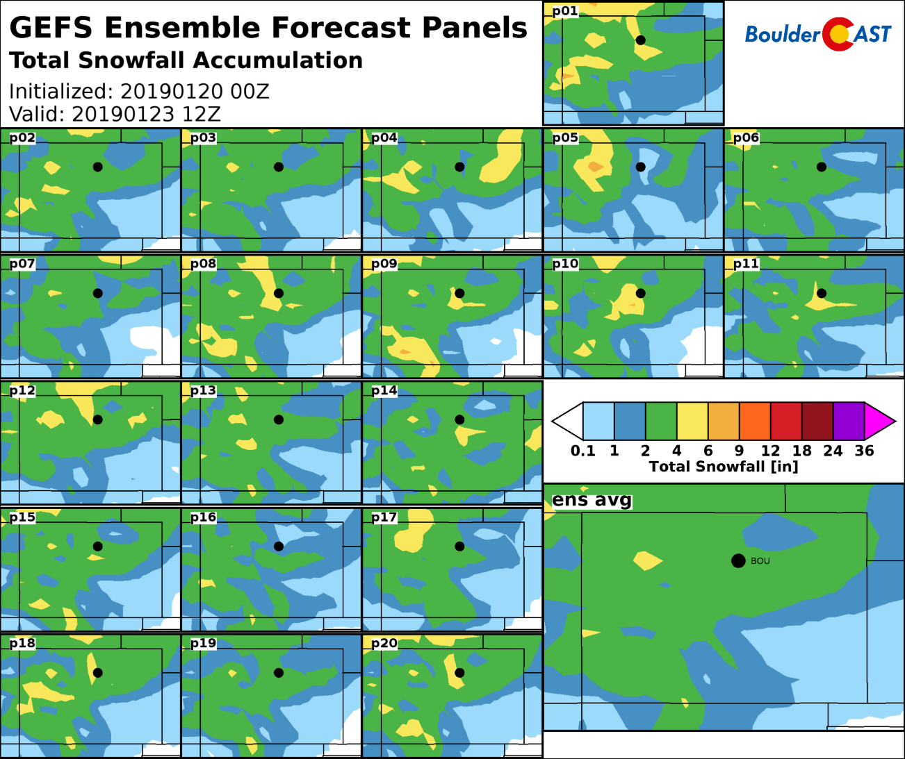
GEFS snowfall prediction
Timeline:
- Precipitation will commence between 5:00PM and 10:00PM this evening. It should start initially as rain, but quickly change-over to all snow. The front will pass through around this same time as well, with northerly winds becoming quite gusty after the passage and temperatures dipping into the 20’s overnight.
- As the front passes before midnight, sharp lift will allow for a few quick bursts of moderate to heavy snowfall across the lower elevations. These should be short-lived however.
- Wind gusts may exceed 30 mph around the Metro area during the overnight hours. Further east, gusts could approach 50 mph at times, with potential blizzard conditions possible. This is where the worst travel conditions will be (between DIA, Limon and Fort Morgan). Heading south out of Denver over the Palmer Divide also isn’t advised. Minor blowing and drifting snow are likely around Denver, too. Use caution if traveling late tonight and early Tuesday.
- Light snow will taper off Tuesday morning, possibly earlier for the northwest sections of the Metro area where downslope will take hold.
Snow amounts:
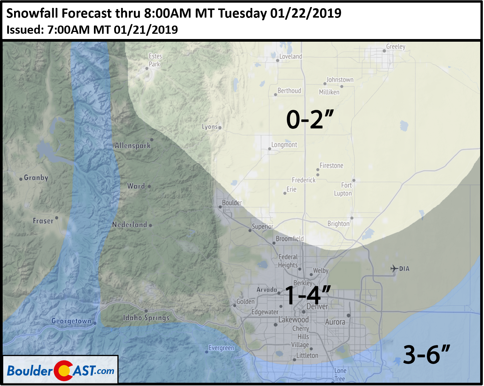
Our official forecast basically is a blend of the regional, global, and ensemble guidance. Overall, snow totals will be hampered by an unfavorable track and quick storm progression, especially from Boulder northward. We’re predicting a general 1-4″ in for the Metro area, with amounts highest in south and southeast Denver where northerly winds will actually help things. Heading north out of Boulder, including Longmont and Fort Collins, expect less than 2″ due to the downslope component anticipated in this area. It’s possible some locations here see no snow at all.
Our forecast confidence is somewhere in the middle right now, neither high or low. If the European model verifies, totals could bust a little higher than our forecast. Despite every other model saying otherwise, we typically don’t like to discount the Euro in set-ups such as these. But alas, our forecast errs on the side of caution with lower totals, especially given the look of the latest high-resolution guidance from the HRRR.
Check PowderCAST for details on the snow potential at your favorite ski resort. Right now it looks like most will be picking up 3 to 8″ from this storm.
Enjoy the MLK Holiday, stay warm tonight, and if travel is in your itinerary, be careful!
P.S. Our next chance of snow may be closer than you think. This and more in our weekly outlook tomorrow…
Premium Flash Sale (MLK Day ONLY): New members save 33% with promo code “MLK-DAY-SNOW”. Sign up HERE.
Help support BoulderCAST by sharing our forecast:
.




You must be logged in to post a comment.