We discuss the insanely dry air out there today….the driest in Boulder since March of 2017. Plus a check on this evening’s cold front and snowfall potential for the Metro area.
Remember, these daily forecasts are Premium content. Periodically, we open this forecast up to all of our readers. Today is one of those days!
Sign up today to get the best BoulderCAST experience, including these daily forecasts every morning, complete 6-day skiing and hiking forecasts, additional storm updates and much more!
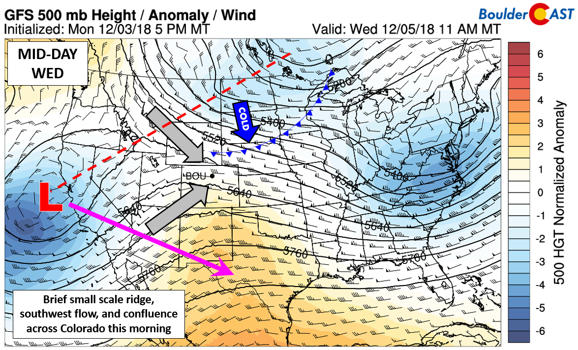
Several factors are coming together to make for a slightly warmer and very dry (humidity-wise) day Wednesday across Colorado. Today’s 500 mb set-up is shown below, with details including:
- A cut-off low pressure system entering California (big red L). This system will be digging south into Arizona and New Mexico by late in the week and will bring snow chances to mainly southern Colorado Friday. There is an outside chance we could see some light snow from this storm as well here in the Metro area, but it likely won’t amount to any real accumulation. This system has been trending southward in the models over the last few days.
- A split pattern is resulting in confluent flow across Colorado at 500 mb (gray arrows). Confluent flow is when winds converge at a given location. This flow leads to sinking air in the atmosphere.
- A small scale ridge axis moving across Colorado today (orange contours below show this nicely). Ridges, as you know, bring subsidence and usually quiet weather.
- Extending northeast from the California system is a trough axis and cold front moving southward across Wyoming and the Dakotas. This front will arrive into Boulder and Denver by early evening.
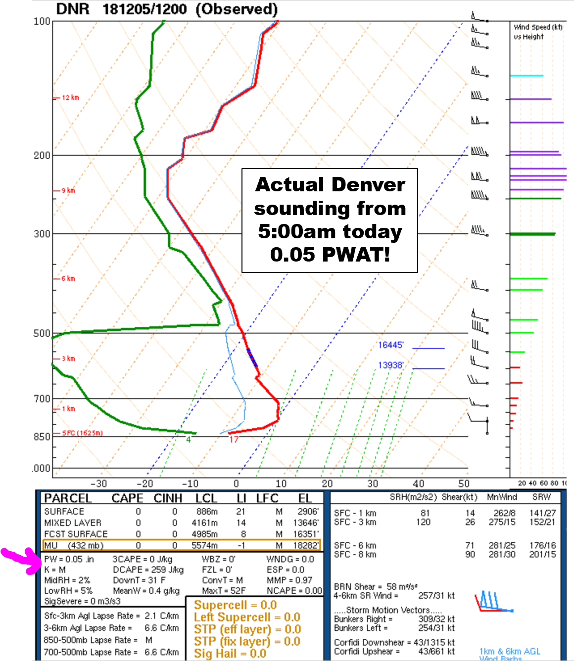
Before the cold front arrives today, the weather will be pleasant, albeit very dry. We discussed the pipeline of dry air yesterday, but it really is rather remarkable to see such an expansive linear feature of dryness. Moisture values (precipitable water) are near record minimums for the date this morning over the Front Range. We haven’t measured a dew point below -5ºF like this morning at BoulderCAST Station since March of 2017! The 5:00 AM data from the balloon launch in Denver this morning is shown below. 0.05″ is a new daily record low for December 5th. The normal moisture for today is 0.22″.
The air is so dry between 500 and 700mb this morning that it is actually “off the chart”. The lowest dew point measured was -85ºF just above the tops of the 14ers.
The forecast maps below show the low precipitable water and also the extremely negative anomalies, on the order of 8 standard deviations over northeast Colorado. There is a significant moisture boundary dividing Colorado this morning and this will be pushing northward through the morning and afternoon.

NAM precipitable water forecast (left) and GFS precipitable water anomaly forecast (right) for this morning.
Remember that precipitable water characterizes the total moisture content of the entire depth of the atmosphere. It doesn’t necessarily say which layers are dry and how dry they are. We can get this information from looking at model soundings (see below). If we gander at several forecast soundings from Monday evening through this morning, one particularly dry layer stands out. Monday evening at 5:00 PM (top left) this layer was located at 350 mb in the atmosphere (about 35,000 feet). As time progresses, we can track this layer downwards in the atmosphere. This morning (bottom right) the dry layer is located near 750 mb (8,500 feet). This slow descent of the dry layer makes sense given the subsidence produced by the weak ridge overhead and the confluent flow discussed earlier.

GFS model forecast sounding for a few times from Monday through this morning. Notice the very dry layer of air slowly descending with time.
(NOT SO?) FUN ATMOSPHERIC MATH: We can actually calculate the average downward vertical velocity of the atmosphere which has been pushing the dry air downwards since Monday. The time change between the top left and bottom right panels is 36 hours or 129,600 seconds. The change in altitude (pressure) was 350mb to 700mb, a change of +350mb or +35,000 Pascals. Thus, the vertical velocity is +35,000 Pascals divided by 129,600 seconds which equals +0.27 Pascals/second (or roughly 0.13 mph). This matches up quite well with what the models show for vertical velocity in each panel in the dry layer. In atmospheric science, the vertical velocity in pressure units is called omega and this is shown as the tiny horizontal bar graphs to the left of each model sounding. Grey bars are sinking motion (positive omega).
Notice that this morning’s sounding above is fully saturated above 400mb. These are mid and upper level clouds which will create partly to mostly cloudy skies through the day today. Even with the clouds, we should have no issues reaching the low to middle 40’s for afternoon highs….our warmest day of the week.
Look for the evening cold front to arrive around sunset with falling temperatures thereafter. Snow will develop overnight mainly near and north of Fort Collins where up to 1″ of accumulation is possible. A few snow showers could push as far south as Boulder overnight with a dusting or less expected. Denver likely will be too far south to see any chance of snow. It will be cold everywhere however with temperatures falling into the lower 20’s and teens tonight.
Don’t expect much change in the weather in the coming days as a rex blocking pattern will keep things stagnant overall. 30’s and 40’s will linger with clouds through Friday before things turn sunny and more pleasant for the weekend.

GFS 500 mb height anomaly forecast for tomorrow morning. A rex block pattern will lead to little change in the weather in the next several days.
Finally, don’t forget to take a crack at our Weather Quiz question before we discuss the answer on Friday. Happy Wednesday!


You must be logged in to post a comment.