3rd Annual BoulderCAST First Snow Contest
*This contest is now closed to entries*
Are you eager for the first snow of the season? Have you already waxed your skis and purchased your Epic Pass? Our first big snow could be right around the corner! We provide a brief overview of Boulder’s first snowfall climatology and then pose a question…“When will Boulder’s first snow occur this year?” Submit your guess for not only a chance to win recognition among local weather enthusiasts, but prizes too. Those who get closest to the date of our first snow win. Read on for all the details.
First snows of Boulder’s past
As we mentioned in our last September outlook, this month is a bit of a mix bag. Our first snow of the year can and often does occur, but we’ve also had 100-degree days in years past. This is the nature of the business during the transitional months in the Denver Metro area. We know your tired of the summer heat, and just want to jump ahead to winter. Let’s briefly review some statistics of Boulder’s annual first snowfall. Hopefully this will give you some context for your contest entry.
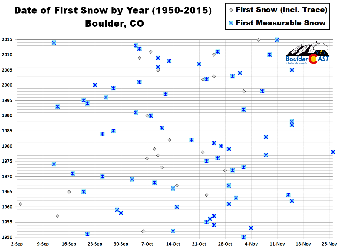
The chart below shows the date of Boulder’s first measurable snowfall for each year dating back to 1950 (blue snowflake icons). By measurable, we mean that officially 0.1″ or more of snow was recorded. As is often the case early in the snow season, a few flakes mix in with rain, or flurries briefly fly, but never stick on the ground. These are instances where a trace of snow has occurred, but wasn’t measurable. Dates where a trace of snow was recorded BEFORE measurable snow are denoted with grey diamonds below.
You can see there is a huge variation from year-to-year in the date of our first measurable snowfall. The earliest was September 12, 2014, with 0.5″ of snow falling. The latest measurable snow was November 26, 1978. That’s a spread of nearly three months! The median date of our first measurable snow is October 20th.
How about a few percentiles for the gamblers out there? The odds of our first measurable snowfall occurring on or before…
- September 20th: 10%
- October 1st: 25%
- October 20th: 50%
- October 31st: 75%
- November 10th: 90%
These numbers work out nicely and equate to our first measurable snowfall occurring in September 25% of the time, in October 50% of the time, and in November 25% of the time.
As you might imagine, our first snow event each year is usually a small dumping…providing only a meager taste of winter. The histogram below shows that 41 years since 1950 had an inaugural snowfall less than 2.9″ (63% of the time). Boulder’s first snow only exceeded 5.7″ on 10 occasions (15% of the time).

Histogram of Boulder’s first snow amounts sinc e1950. The side shows the frequency of occurrence, while the bottom axis has intervals of snowfall amounts in inches
The average amount of Boulder’s first snow is 3.0″, while the median amount is 2.0″.
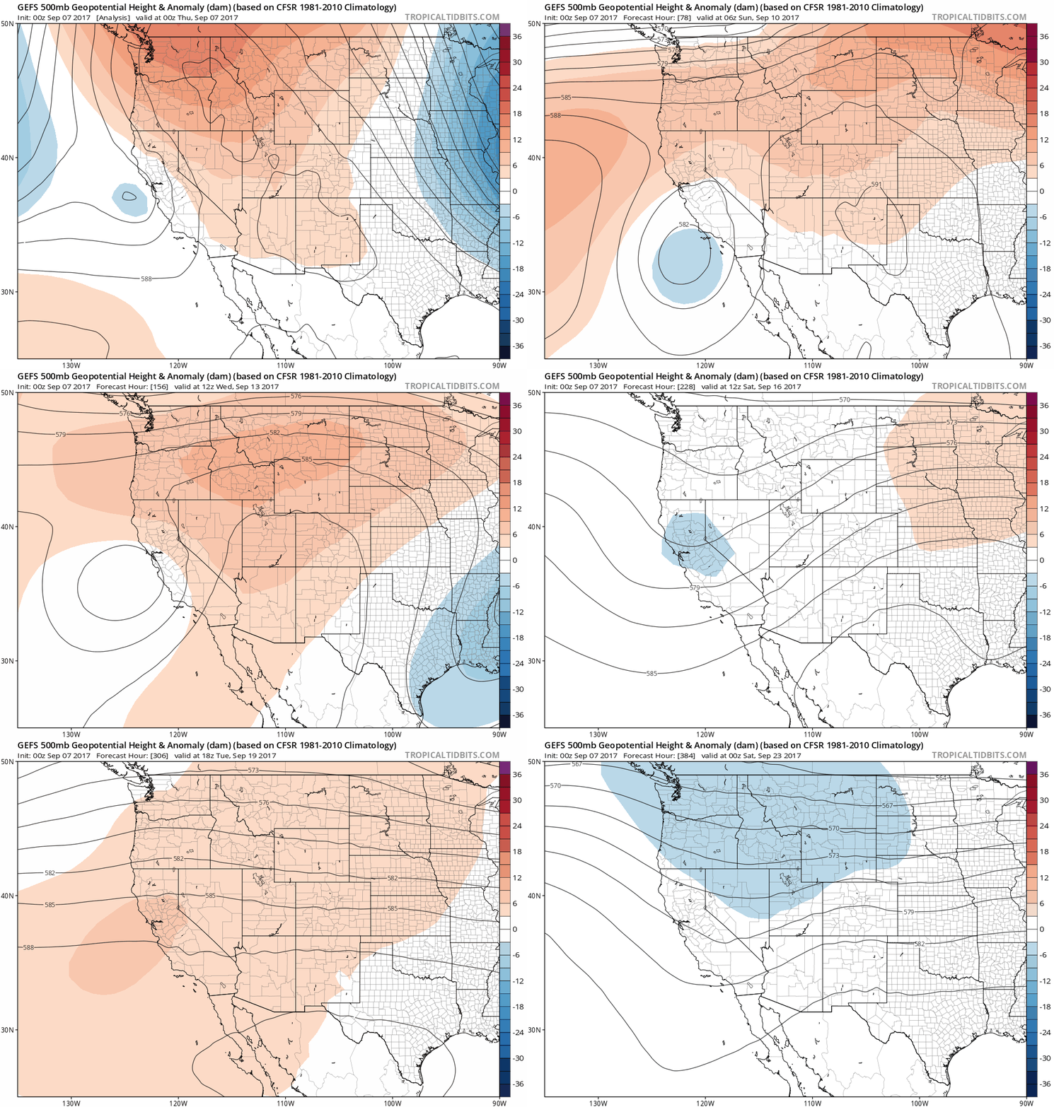
With that brief history lesson complete, let’s discuss the possibility of snow in the near-term. Taking a look at the last several ensemble forecast runs from the GFS and the European models, we’re not seeing anything that hints that snow is likely or even possible in Boulder through September 23rd (the GEFS 500 mb height anomaly is animated below). This time of year, so early in the season, just about the only way snow can happen on the Front Range Plains is if an epic trough develops across the western United States, forming a cut-off system that funnels extremely cold air southward east of the Rockies along with some upslope.

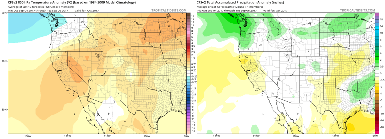
Almost all indication from long-range guidance is that the next 30 to 60 days will be warmer than normal across Colorado and much of the United States. While it only takes one brief shot of cold air to give us our first snow, odds seem to be our first flakes may be LATER rather than sooner this year.

Climate Forecast System outlook for October 2017 for temperature (left) and precipitation (right).
Contest specifics and prizes
We thought it would be fun to create a community poll for the date we all think the first MEASURABLE snowfall will occur in Boulder. Those who come closest to the actual date are winners. For verification, we’ll go off the official Boulder climate station located at the NIST building in south Boulder (FYI, they follow UTC time for date cut-offs).
For prizes, we’re giving away free BoulderCAST Premium subscriptions. As a reminder, BoulderCAST Premium members get full-access to our daily forecast discussion every morning at 5AM. This is especially useful in the winter, when our meteorologists brain-dump thoughts for days leading up to impactful snowstorms. In case you weren’t with us the last few winters, we did quite well for the entire Denver Metro area’s snow forecasts (2015-16 Recap / 2016-17 Recap). Premium members also have admittance to the 24-hour version of our hourly forecast, complete 6-day hiking and 3-day ski forecasts, have early viewing of select content, can request custom forecasts, and other added perks. Read our announcement post for more information.
The prizes for the contest are as follows:
- 1st place: 6-month subscription to Premium + BoulderCAST T-Shirt
- 2nd place: 3-month subscription to Premium
- 3rd – 5th places: 1-month subscription to Premium
- All other places: Virtual “pat on the back”
In the event that multiple participants select the same date, the tie-breaker of snowfall AMOUNT will be used.
To get things started, here are the dates that the BoulderCAST Team has placed their bets on:
- Ben: November 5th – 1.5″
- Andy: October 10th – 5.0″
- Josh: November 2nd – 2.0″
- Keah: October 27th – 2.0″
Enter you NAME, EMAIL, and guesses for DATE and AMOUNT in the form below on or before September 15, 2017. Please only one entry per person.
Prizes and recognition will be awarded in the days following our first dumping of snow. Let’s hope it’s a big one!
SPECIAL PRE-WINTER PROMOTION: Use the offer code “I-LOVE-SNOW” on or before September 15th to save 25% on a BoulderCAST Premium annual subscription.
.
BOULDERCAST 2017-2018 FIRST SNOW CONTEST ENTRY FORM
*Contest is now closed*
*We respect your privacy. Your email will not be used for anything more than to contact you in case of meteorological victory.*
.
Help us reach more people before winter! Share this contest with your friends:
.


You must be logged in to post a comment.