Sunday’s storms brought a slew of severe weather to northeast Colorado, including a photogenic tornado east of Denver. This week will be relatively quiet, but there is still plenty to discuss. Monday will stay cool and showery, but drier and warmer weather is on-tap for the rest of the week. However, a weekend trough will threaten to shake things up again—could the Memorial Day Weekend forecast include stormy skies? Read on for all the details.
Category: Winter Weather (Page 7 of 134)
These posts contain some discussion of the white stuff, whether it be mountain snow pack or a Front Range snowstorm.

April 2025 was a mild and mostly dry month across the Front Range, with almost all of the precipitation coming via a mid-month snowstorm that blanketed Boulder in 8 inches of slop. Here’s a quick and colorful graphical recap of our weather during April and how it relates to climatology.
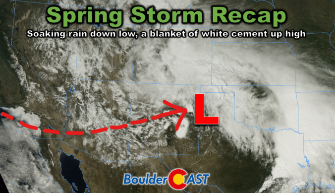
This week’s slow-moving spring storm drenched the Boulder-Denver area with widespread soaking rain, while elevations above 7,500 feet were blanketed in dense, heavy snow. As the storm begins to wind down, we take a look at how it unfolded and review the final rain and snow totals.
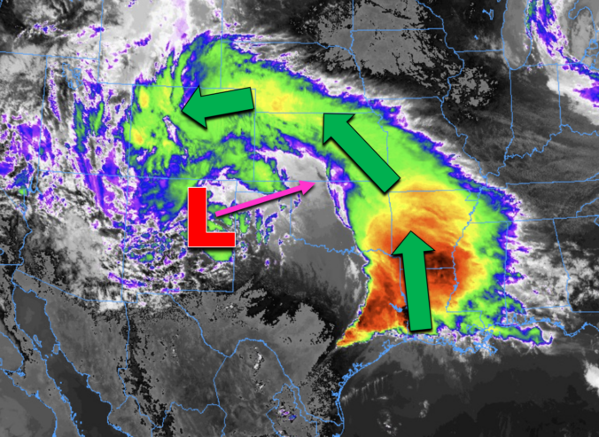
Many of us have already received more than one inch of rain, and this storm isn’t over quite yet. Scattered showers and a few thunderstorms will continue through Wednesday (with snow in the highest Foothills). We review the regional rain and snowfall totals so far, and discuss the latest forecast details, including when we expect this pesky spring storm to finally loosen its grasp on the Front Range.
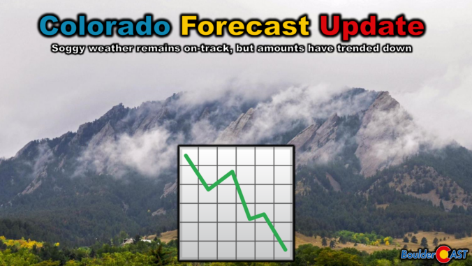
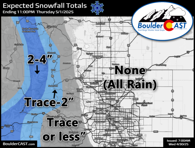
We hate to be the bearer of bad news, but almost every single weather model has taken a significant nosedive in precipitation output for the remainder of the storm Tuesday into Wednesday. We discuss this latest data, what factors have contributed to the shift, and provide our final snowfall and precipitation forecast maps for what may end up being an underwhelming spring storm in the Front Range.
Get ready for soaking rain across the lower elevations, with heavy wet snow in the higher terrain of the Front Range. A powerful spring storm will impact Colorado this week, allowing for a lengthy period of deep upslope infused with Gulf of Mexico moisture. The bulk of the storm’s energy will hit from Monday afternoon through early Wednesday, bringing a dramatic shift in weather conditions to the area. Thick clouds and precipitation will keep temperatures feeling brisk, but by the end of the week, high pressure will return, ushering in a more seasonal warmth. Just how much rain are we expecting this week? How deep will the snow pile up in the Foothills and Mountains? And how far down could the snow levels plunge at the storm’s peak? Read on as we break it all down in this week’s outlook.
Unsettled weather will stay the course this week across Colorado, with a lingering trough keeping rain chances alive early on. A stronger cold front arrives midweek, boosting precipitation chances and bringing a brief return of wintry weather to the higher terrain. Though the weekend ahead looks quite nice, a soggy pattern could be brewing next week. Read on for all the details.

Live View of Boulder

Current Conditions

Live Radar

Recent Premium Posts

BoulderCAST Daily – Sun 01/11/26 | A mild Sunday with readings reaching the 50s
🌤️ Mild & Melty Sunday: Light winds and patchy clouds, with lingering snowpack …
BoulderCAST Daily – Sat 01/10/26| Widespread sunshine and moderating temperatures this weekend as our recent snow melts off
🌤️ Calm Saturday: Winter storm systems have departed the state, leaving behind a …
BoulderCAST Daily – Fri 01/09/26| Snow ends quickly this morning with a quieter weekend in store
❄️ Overnight snow bands: A second push of upslope after midnight sparked narrow …
3-Day Forecast

Trending Content

© 2026 Front Range Weather, LLC