The faucet of Gulf of Mexico moisture is on full blast into Colorado today! Moderate to heavy snow is beginning across the Front Range NOW and will continue through early Saturday, at times mixing with rain on the north side. We discuss the latest on the approaching low pressure, take a tour through the most recent model data, and provide a few final details leading into this big and wet snowstorm!
Category: Winter Weather (Page 18 of 134)
These posts contain some discussion of the white stuff, whether it be mountain snow pack or a Front Range snowstorm.
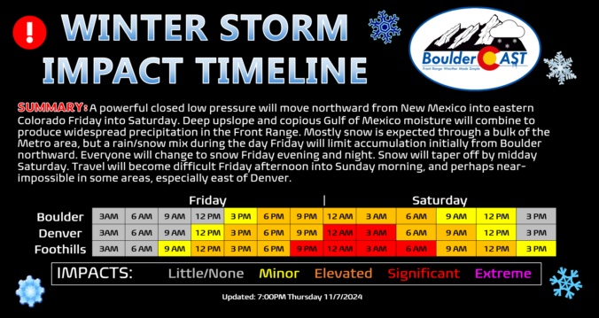
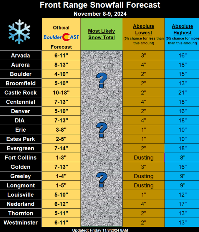
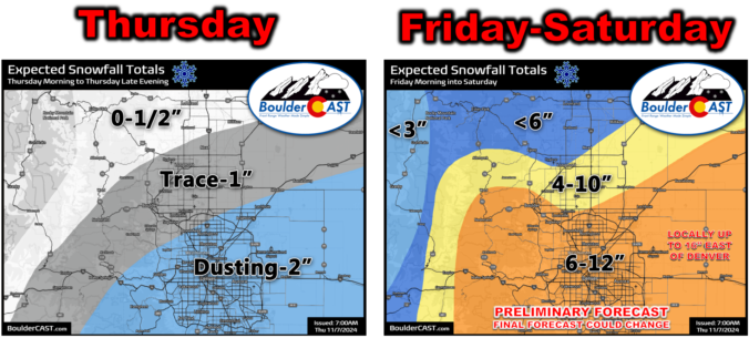
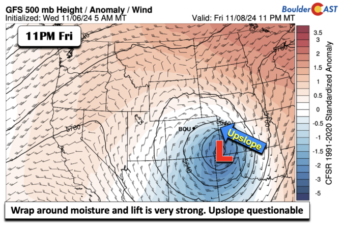
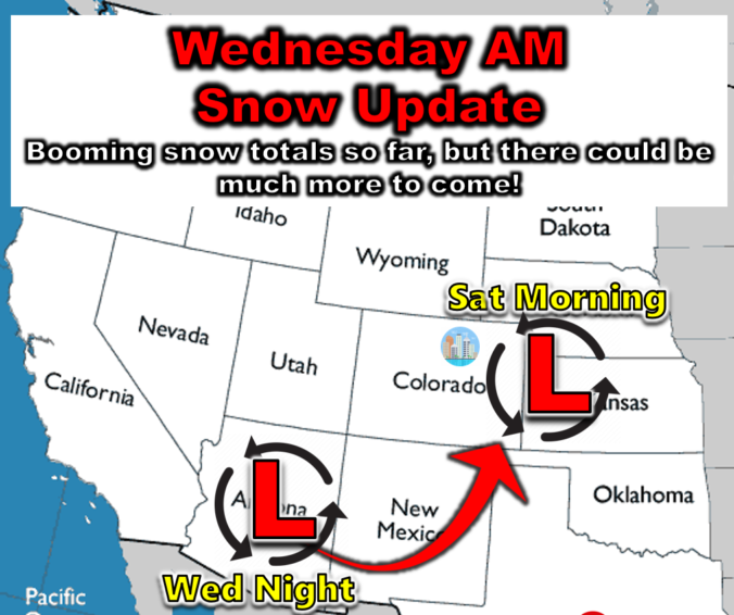
After already delivering a thick blanket of snowfall earlier in the week, the very same storm system is set to boomerang back north and slam eastern Colorado once again with widespread precipitation Friday into Saturday. With temperatures not as cold as last time, the storm’s impact will vary across the region, with plenty of heavy snow to go around, but also unfortunately with chilly rain spoiling the party a bit for northern cities. We discuss expected snowfall amounts, potential travel impacts, and the unique meteorological conditions contributing to what will be an extreme event for some parts of eastern Colorado to end the week.
Premium Storm Update (11/9/24 9:00 AM): The faucet of Gulf of Mexico moisture is on full blast into Colorado today! Moderate to heavy snow is beginning across the Front Range NOW and will continue through early Saturday, at times mixing with rain on the north side. We discuss the latest on the approaching low pressure, take a tour through the most recent model data, and provide a few final details leading into this big and wet snowstorm! READ HERE

A prolonged period of light to moderate snow fell across most of the Denver Metro area Tuesday evening into Wednesday evening. We briefly review the booming snowfall totals from the first real dump of snow in the nascent 2024-25 season!
The onset of snowfall Tuesday evening was earlier and heavier than expected leading to booming overnight snow totals which range from 1 to 10″ across the Front Range already. We’re still far from done with this storm and its associated challenging forecast, with additional light snow expected today and Thursday, followed by potentially heavier snow late on Friday as the main storm system passes directly across eastern Colorado. Read on for the latest developments on what should be a cold and snowy rest of the week!
A new storm system will drop across far western Colorado Tuesday night, but it’s heading for the deserts of southern Arizona. In the process of bypassing the Front Range, it will bring light snow to the Denver Metro area starting Tuesday night as temperatures tumble below freezing. Intermittent snow showers and flurries will linger through the day Wednesday leading to minor accumulations in Boulder and Denver, but higher totals are favored further south. There is also the potential for a more impactful storm to hit our area on Saturday, but that continues to look more unlikely by the day. Read on for the latest on the chilly and unsettled days ahead.
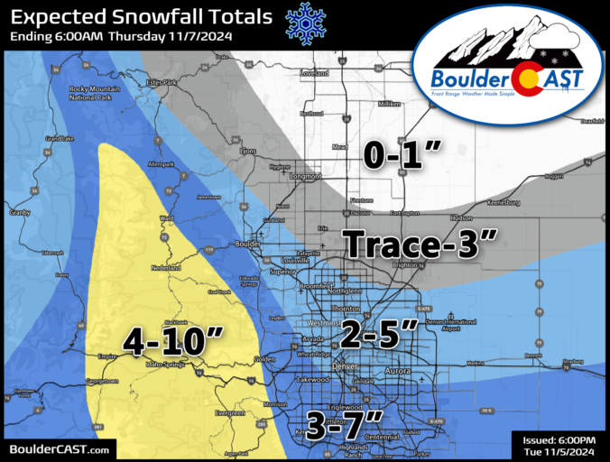
Updated (Tue 11/5/24 7:00 PM): The higher-end outcomes we touched on in the original post have become more likely give the latest model guidance. Though some snowflakes are already flying, we have amended our snowfall forecast map with a slight increase of 1-2″ across the board for the Metro area. Remember this is a long duration (mostly light) snowfall event, lasting from Tuesday evening at least into Wednesday afternoon. Light snow may continue well into Wednesday night, but this is still uncertain. Forecast snow totals will be reached over time, not immediately.
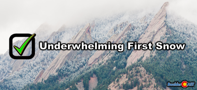
Many western suburbs of Denver experienced their first snow of the season last night, with Boulder officially recording 0.2 inches. The colder, higher elevations to the west saw a more significant dump, up to 15 inches in some areas. We briefly recap the underwhelming first snow of the season and announce the winners of our 2024 First Snowfall Contest.

Live View of Boulder

Current Conditions

Live Radar

Recent Premium Posts

BoulderCAST Daily – Wed 01/14/26 | A gorgeous Wednesday ahead of increasing fire danger & a stronger cold front tomorrow
🌬️ Weak front overnight — A weak cold front slipped through around 9:30 …
BoulderCAST Daily – Tue 01/13/26 | A thick blanket of high clouds won’t stop us from reaching the 60s again
☁️ Thick cloud deck overhead — Moisture streaming in aloft brings widespread mid‑ …
BoulderCAST Daily – Sun 01/11/26 | A mild Sunday with readings reaching the 50s
🌤️ Mild & Melty Sunday: Light winds and patchy clouds, with lingering snowpack …
3-Day Forecast

Trending Content

© 2026 Front Range Weather, LLC