Category: Winter Weather (Page 12 of 134)
These posts contain some discussion of the white stuff, whether it be mountain snow pack or a Front Range snowstorm.
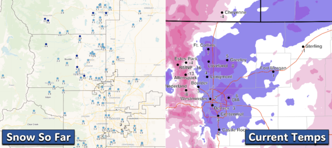
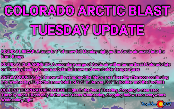
Our second Arctic Blast of 2025 is already underway! The first round of bitter cold has already gripped the Front Range, with light snow falling last night and temperatures plunging into single digits this morning. However, the worst is yet to come! Another wave of Arctic air is set to sweep through later on Tuesday, bringing several inches of snowfall and eventually sub-zero temperatures to the entire area. We discuss the latest forecast details, including when this next round of snow will begin and end, expected snowfall amounts across the area, and just how cold it will get in the days ahead.
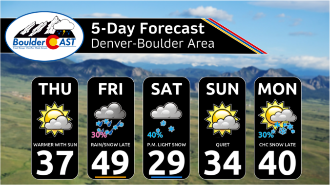
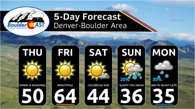
Following a bitter cold and snowy January in the Front Range, the month of February so far has brought with it milder conditions. Last week we had our first 60-degree day in Boulder since just before Christmas, and even our first 70-degree day since late October. The warmer weather has been a welcomed reprieve, though it has rightfully confused some flowering plants across the area with early blooms. This warm weather was never going to last though — we’ve still got plenty of winter to go and this week will get us right back on-track with a two-part blast of Arctic air and snow headed for the Front Range. Read on for the latest details on the snowfall timing, amounts, and expected temperatures.
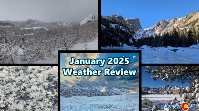
Hot on the heels of an extremely warm and dry end to 2024, January landed on the complete opposite end of the spectrum with well above normal snowfall and very cold conditions across much of Colorado, including here in Boulder. Here’s a quick and colorful graphical recap of our weather during January and how it relates to climatology.
While Punxsutawney Phil and Flatiron Freddy both saw their shadows Sunday morning solidifying their predictions for six more weeks of winter, we’ll start off February with wildly above normal temperatures in the 60s to lower 70s here in the Front Range. However, we are watching an Arctic cold front that will peskily waver back and forth across northeast Colorado as the week progresses leading to fluctuating temperatures and plenty of uncertainty. The brunt of the cold air, though, likely will not plunge into our area until sometime next week alongside increasing chances for snowflakes.
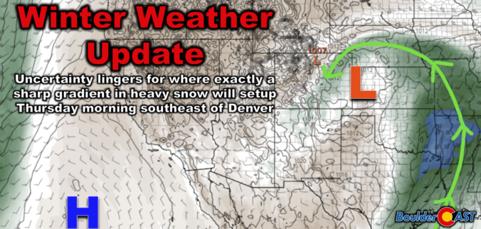
A medium-impact winter storm is headed for eastern Colorado, bringing some snowfall and strong winds to parts of the Denver Metro area late Wednesday night into Thursday afternoon. Weather models show varying predictions, but the southern and southeast suburbs of Denver are favored most for up to a couple inches of snow, with higher totals possible along and east of the Palmer Divide. We discuss the rift in the model guidance that is leading to the uncertainty, as well as the latest timing and most likely outcome from this somewhat warmer southern-track winter storm.

Live View of Boulder

Current Conditions

Live Radar

Recent Premium Posts

BoulderCAST Daily – Sun 01/11/26 | A mild Sunday with readings reaching the 50s
🌤️ Mild & Melty Sunday: Light winds and patchy clouds, with lingering snowpack …
BoulderCAST Daily – Sat 01/10/26| Widespread sunshine and moderating temperatures this weekend as our recent snow melts off
🌤️ Calm Saturday: Winter storm systems have departed the state, leaving behind a …
BoulderCAST Daily – Fri 01/09/26| Snow ends quickly this morning with a quieter weekend in store
❄️ Overnight snow bands: A second push of upslope after midnight sparked narrow …
3-Day Forecast

Trending Content

© 2026 Front Range Weather, LLC