fleeting brush with winter may have swept across the Front Range this past weekend, but the atmosphere isn’t planning to stick with the theme for long. That sharp Arctic plunge—while refreshing for snow lovers—was more of a brief interruption than a true turning point. A closer look at the pattern ahead shows Colorado snapping right back into its now‑familiar routine of warm afternoons, bone‑dry air, and a statewide snowpack sitting at record‑low levels. Winter may have knocked on the door, but it certainly isn’t moving in.
Category: Verification (Page 1 of 52)
These posts take a look back at recent weather events, like snow storms or severe weather outbreaks, and evaluate how the forecast played out. We evaluate how well the models predicted what actually occurred, and offer insight into what can be learned and applied moving forward.
A quick round of overnight snow is already over and done with in the area as of Monday morning, but it’s just the opening act in a busy week of weather across the Front Range. Several cold fronts are lined up to keep temperatures bouncing around, including a late‑week Arctic surge that could deliver the coldest air of the season and a chance for additional snow. Read on as we break down the timing of at least three different cold fronts, the associated wind and fire‑weather concerns, and what to expect as that Arctic air barrels in later this week.

A tandem of low pressure systems — one warm and moisture‑rich, the other colder and more dynamic — teamed up just enough to deliver a surprisingly efficient burst of snowfall across the Front Range to end the week. We break down how this two‑part event unfolded, why the timing mattered so much, and where our forecast over‑ and under‑performed. Continue reading
A few wobbly overnight snow bands dropped a light, fluffy coating of powder across the Front Range—right on target with our forecast. We break down where the bands hit, why the snow ratios were so sky‑high, and what this tiny event means for our growing seasonal deficit. We also look ahead to the warm, dry pattern set to carry us into the New Year.
After a stretch of December warmth so extreme it rewrote some record books across the Front Range, we’re finally staring down a pattern shift—though not quite the snowy one we initially hoped for. A pair of cold fronts will bring a sharp temperature drop, a few chances for rain and snow, and at least the feeling of winter back to Boulder and Denver. The details have changed quite a bit in the last 24 to 48 hours, but we’ll walk you through what’s still on the table, what’s no longer likely, and where a few surprises could still sneak in Saturday night.
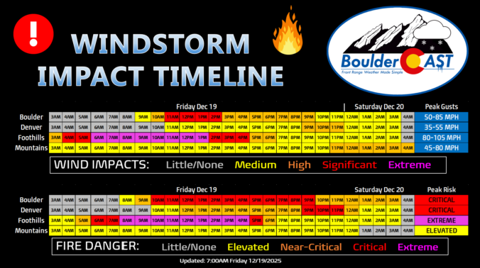
Updated (7AM Friday 12/19): Updated based on latest guidance adjusting timings and intensity of wind/fire impacts, and also made a stronger case for the extreme winds (and fire danger) to potentially stay mostly in the Foothills or very close to there. Lowered wind/fire risk in Boulder proper. This is still a very dangerous situation.
—
Boulder, the far western suburbs of Denver, and the Foothills are bracing for yet another powerful mountain wave windstorm Friday, with gusts likely topping 75–100 MPH and, this time, extreme fire danger will be layered on top. Forecast models show the strongest winds during the morning into the afternoon, coinciding with critically dry air and record‑challenging warmth. Power shutoffs, downed trees, and blowing dust are all on the table, but the bigger story is the fire risk—conditions are primed for rapid spread if any ignition occurs. Fortunately it now appears that most of the intense winds will stay largely in the Foothills, but there is some uncertainty how far downhill and east they will reach. Read on for the full breakdown of timing, impacts, and what you need to know to stay safe. We also briefly review the damaging wind event that just occurred on Wednesday.
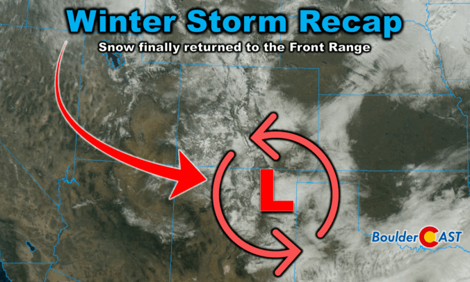
Winter finally showed up in style this week along the Front Range. After a sluggish start to the season, our first true snowstorm delivered nearly 18 hours of steady flakes, painting Boulder, Denver, and much of Colorado in white. But this wasn’t just a simple upslope event—there were some fascinating atmospheric twists that kept the snow machine running longer than expected. We review the storm setup and snowfall totals which greatly favored the western side of the Metro area including Boulder.
A few snowflakes fell across the area Sunday evening with some jet-forced snow bands around. These were largely south of Denver leaving just a trace of snow for most of us. The Mountains made out better with several inches of orographic snow piling up under moist northwesterly flow. We briefly review both the snow totals from this single storm and the seasonal ones.

Live View of Boulder

Current Conditions

Live Radar

Recent Premium Posts

BoulderCAST Daily – Tue 01/27/26 | Early morning clouds will give way to a sunny Tuesday
🌤️ Clouds Clearing Fast — Early morning mid‑level clouds from northwest flow fade …
BoulderCAST Daily – Sun 01/25/26 | Light snow develops later today into this evening
❄️ Light snow this afternoon and tonight: A fast-moving clipper type system brings …
BoulderCAST Daily – Sat 01/24/26 | Bitter Cold This Weekend With Light Snow Again Sunday
🥶 Arctic blast is here: Arctic Air lingers through the weekend with teens …
3-Day Forecast

Trending Content

© 2026 Front Range Weather, LLC