
The North American Monsoon is responsible for pumping subtropical moisture into the southwestern United States every summer, moisture which ultimately supplies the fuel for Colorado’s daily summertime thunderstorms — rain we desperately need in the Front Range right now following months scarce precipitation and worsening drought. However, the arrival and intensity of the summer monsoon varies substantially from year to year, especially in our area. In this long-range outlook, we discuss the developing dire drought situation, the current state of the monsoon, what’s happening with El Niño, and what to expect for weather in the coming months across Front Range Colorado.
Category: Tropical Weather (Page 5 of 19)
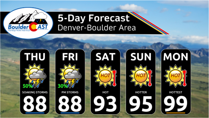
Say goodbye to those 70s we had on Sunday. Record-setting heat is queuing up later this week as a strong ridge will build into the area from the Desert Southwest. With this, expect progressively warmer daytime highs as the week wears on, eventually soaring into the lower 100s by Friday and into the weekend ahead. Alongside the heat, there will be very limited chances for rain this week, with any storms that do manage to form in this hot and dry airmass being mainly confined to the Mountains and Foothills.

This week’s weather in the Front Range will feature a welcomed northwest flow pattern, one which will usher in cooler temperatures but unfortunately little in the way of rainfall as the monsoon remains at bay. Several disturbances will be tracking across northern Colorado but will have extremely limited moisture to work with resulting in most areas staying nearly bone-dry this week. While not good at all for the ongoing drought, this setup will allow for cool and beautiful conditions for the Fourth of July — just be mindful that fire danger is growing. Read on for all the details.
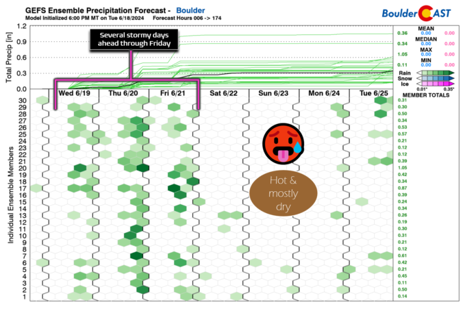
This week in the Front Range will feature a rollercoaster ride of temperatures from 90s to the 70s and back again! There will also be increasing rainfall chances for the mid to late-week period as remnant moisture arrives from a tropical system in the Gulf of Mexico — this is not the beginning of our seasonal monsoon just yet. Temperatures will slowly ramp up back into the 90s for the upcoming weekend. Read on for more details.
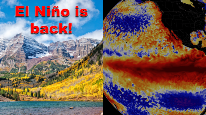
After enduring three consecutive La Niña winters, El Niño has taken over the globe once again intensifying in unusually rapid fashion. As of writing in mid-October, a strong El Niño is underway with impacts that will stretch globally in the months to come. We take a look at the current state of ENSO and what to expect from Mother Nature this winter across the Front Range lower elevations and Mountains.


Live View of Boulder

Current Conditions

Live Radar

Recent Premium Posts

BoulderCAST Daily – Sat 01/10/26| Widespread sunshine and moderating temperatures this weekend as our recent snow melts off
🌤️ Calm Saturday: Winter storm systems have departed the state, leaving behind a …
BoulderCAST Daily – Fri 01/09/26| Snow ends quickly this morning with a quieter weekend in store
❄️ Overnight snow bands: A second push of upslope after midnight sparked narrow …
BoulderCAST Daily – Thu 01/08/26 | Snow develops today but still some uncertainty, amounts have been lowered
❄️ Snow develops today: Snow develops today, but uncertainty still lingers with two …
3-Day Forecast

Trending Content

© 2026 Front Range Weather, LLC