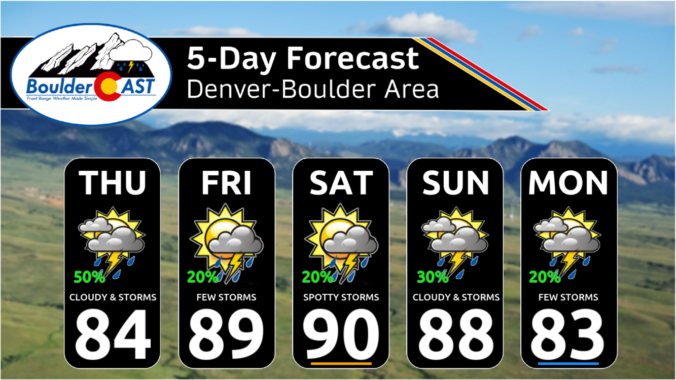
Yesterday's shortwave disturbance, the one which brought overcast skies and a few raindrops to the Denver Metro area, has kicked off into the Dakotas overnight. As it exited, drier air has swept across Colorado from the northwest, beginning around 5PM yesterday for the Boulder area. This dry air will be in place today leading to a beautiful Tuesday for us …
The instability axis today will be greatest across western sections of Colorado and over the High Country, as noted in the image below (box region). Even though the moist flow will be anomalous once again, it appears chances of storms today will be less on the Plains. Not that yesterday was all that wet, either, but it looks spotty again …
The moist flow will become more favorable today and tonight. High pressure will be situated over Oklahoma and Texas, while a trough positions itself across the western United States. As a result, we'll see a more south-southwesterly flow, a tad more backed than Friday. As a result of that flow, we'll see storms initially firing over the southwest and south-central …
The moist flow will continue today at mid-levels, with the ridge of high pressure to our southeast and a trough to our northwest. However, although storms are in the forecast again today, coverage and overall chances are more isolated and lessened than what we had on Thursday. One reason for that is the mid-level flow is ever so slightly out …
The hearty plume of monsoonal moisture remains draped across Colorado this morning. In fact, precipitable water will peak today throughout the Front Range at around 2 to 2.5 standard anomalies above normal, before declining slowly in the coming days. The subtropical faucet can be seen in this morning's GOES-East water vapor animation below, with deep moisture (blues/whites) pumping into our …
Quite a bit of clouds have spread into the Front Range overnight from the southwest making for a surprisingly gloomy morning out there. These can be seen in the GOES-East nighttime cloud microphysics animation below rotating into our area along the northwestern periphery of high pressure in New Mexico. These clouds are tied to a weak shortwave disturbance and are …
Temperatures will once again remain above normal today pushing into the low to middle 90s across the Denver Metro area --- our third 90-degree day in a row. There are some clouds around this morning, but those will thin out as the days wears on into the afternoon before clouds increase again later. Unlike the last few days, today will …
🌤️ Storm Exit — The stubborn upper low that brought days of clouds, …
3-Day Forecast

Did You Know?
When making a forecast, we often look at the 700 mb relative humidity map. In Colorado, this is about 5,000 feet above the ground on the Plains. We use this level because clouds typically form around this height.