Category: Premium Content (Page 84 of 451)

This content is for Premium Members only.
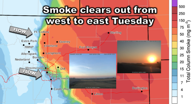
Premium BoulderCAST Daily – Tue 10/08/24 | Smoke clears out from west to east as we push towards 80 degrees yet again

Athick cloud of wildfire smoke moved into the Front Range Monday evening around 6PM from the northeast. You can see the wall of smoke pushing across the Denver Metro area in the visible satellite animation below. This smoke was mostly created by large fires burning in Wyoming and Idaho. Smoke particles still linger across the Metro area this morning, but …

Premium BoulderCAST Daily – Sun 10/06/24 | Cooler to end the weekend

Acold front from yesterday has settled along the Foothills and southern Plains today. Easterly flow has returned and also has some cooler weather. Our highs this afternoon will range from the upper 70s in Boulder to the low 80s in Denver. This is still some 10-12 degrees above seasonal normals, but it will feel good nonetheless. For the week ahead, …

Premium BoulderCAST Daily – Sat 10/05/24 | Red Flag Warning Today

Astrong flow aloft will be in place as a trough over the upper Midwest tracks eastward. The flow at mid and upper levels ranges from 40 to 50 knots. This trough will be a player in setting up Red Flag conditions this afternoon. Temperatures will rise into the middle 80s this afternoon. This will be ahead of a cold front …

Premium BoulderCAST Daily – Fri 10/04/24 | Warming up to end the work week

Tsomewhat cooler airmass yesterday is long gone, moving up into the upper Midwest. High pressure is also moving off to our east, allowing return southwesterly flow to bring warmer air back into the region. Highs this afternoon will be in the low to middle 80s. Tomorrow, a front will approach as a deep trough dives into the central and northern …

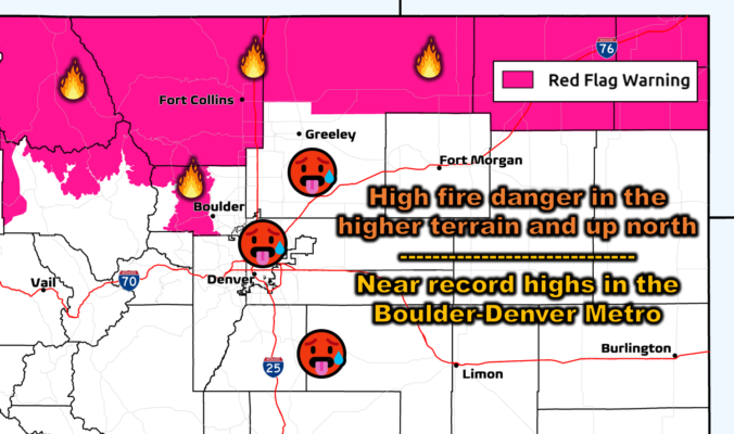
BoulderCAST Daily – Wed 10/02/24 | Near-record heat with high fire danger to the north, no rain/snow for the next week

After a relatively chilly Tuesday, things will turn toasty again across the Front Range today as downslope flow briefly gets enhanced by a weak disturbance passing across Wyoming and northern Colorado. In the 500mb height animation below, notice today we will be under west-northwest flow. The height lines ever-so-slightly dip into northern Colorado tonight before rebounding back northward by Thursday …

Premium BoulderCAST Daily – Tue 10/01/24 | Cooling off behind a cold front

Acold front that moved through yesterday morning has brought a cooler airmass to the region today. Easterly flow persists today, along with an airmass that will produce highs some 8 degrees cooler in the mid to upper 70s. The lowest highs will be felt in Boulder. Our NowCAST is showing some areas of Denver may only reach 74 degrees. This …

Premium BoulderCAST Daily – Sun 09/29/24 | Highs close to 90 and tropics are quite active still

Aridge of high pressure will slide off to our east just a tad today, over the northern Great Plains and upper Midwest. Southerly flow will be in full swing, aiding above normal temperature anomalies over much of our region. We should see highs right around the 90-degree mark this afternoon. There is relief on the way, though. A cold front …

« Older posts Newer posts »