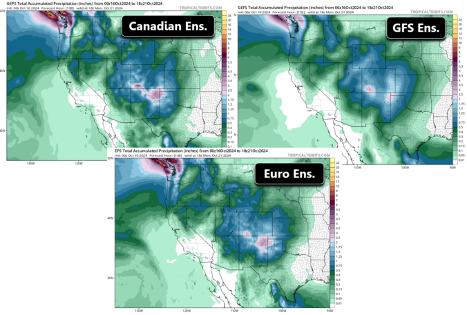
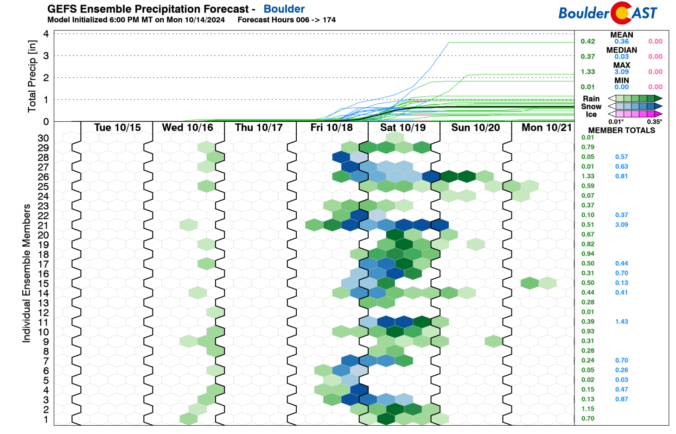
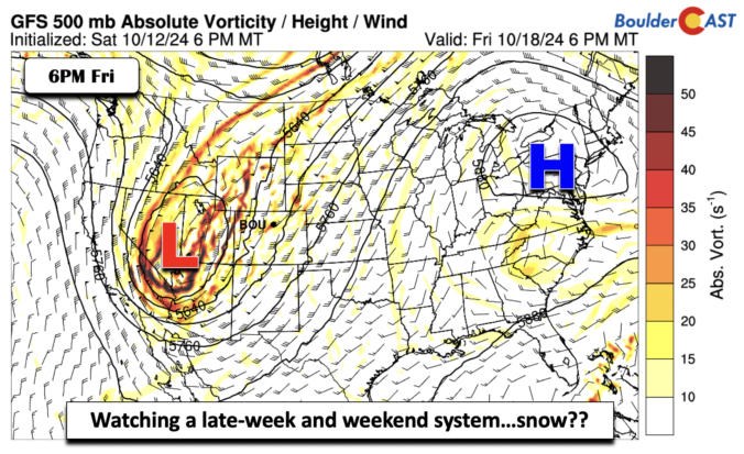
Skies are mostly clear across the Front Range this morning, but a weak area of low pressure is looming off to our southwest in Arizona. The leading edge of a large trough is coming ashore in the Pacific Northwest, which is our highly-anticipated weather-maker for the end of the week and weekend ahead. This approaching trough will help to kick …
Happy Ides of October! Yesterday's high temperature was 82°F in Boulder which was three degrees shy of the daily record high (85°F from 1962). Nothing screams fall like 80-degree warmth! However, a weak and dry cold front will move through during the morning. This will knock our temperatures back down to around 70 degrees this afternoon. Some places may remain …
Another dry and weak cold front moved through our region. As a result, we'll see that rollercoaster ride of temperatures dropping back into the middle 70s for this afternoon. We'll discuss this more in our weekly post tomorrow, but suffice to say that there could be an impactful late-week system come Friday or the weekend. The GFS is showing a …
An upper-level trough centered over southeastern Oregon will be slowly moving east into late Sunday and early next week. As it makes that eastard trek, it will bring mid and high clouds to the state. Today we'll see a noticeable uptick in high clouds into the evening hours. A pre-frontal trough today has pushed through the area, bringing west-northwest flow. …
Avery shallow cold front moves through this morning, roughly between 8 and 11 am. Behind it, a slightly cooler airmass will lower our high temperatures by about 10 degrees in the low to mid 70s. Northeast flow will follow, which will unfortunately bring back in some smoke and haze. The front is quite shallow based on just 5,000 feet above …
The wave of smoke that arrived into the area yesterday afternoon was quite dramatic, with air quality tanking to Unhealthy for Everyone (150+) for a short time in some locations. This is the view from Gunbarrel yesterday as a beautiful Wednesday afternoon morphed into pea soup. Fortunately the smoke dissipated rather quickly and things are looking a lot better for …
Mostly clear skies are noted across much of the country on satellite this morning, including here in the Front Range. There's just a couple small wave clouds around at this hour. Category 5 Hurricane Milton can be seen screaming towards Tampa Florida, and weakening as well, in the Gulf of Mexico. Milton is on-track to make an unfortunate landfall late …
🎃 🌫️ Halloween Day starts off with fog — Seasonable temperatures near 60° …
3-Day Forecast

Did You Know?
Have you ever considered the indirect effects of climate change? For example, as our climate warms, the territory habitable for bark beetles expands. As they take over and kill our evergreens, forests become primed for wildfires. More wildfires, like the Flagstaff Fire and Fourmile Fire that occurred near Boulder in the last few years, ultimately contribute to flooding by increasing run-off.