The mid-level ridge we mentioned yesterday has just passed to the east of Colorado now with quiet conditions expected statewide under its influence once again. The main change in our weather today will be the return of milder temperatures thanks to warm air advection in the southwest flow. Here's how things are looking from space this morning on the GOES …
Last evening's shortwave trough brought gusty northwest winds and a brief smattering of rain/snow showers to the Front Range, though only a few hundredths of an inch of precipitation were reported from these showers which mainly resided north and northeast of Denver Tuesday evening. GOES-East (with reanalysis 500mb model data overlaid) shows us that the trough has exited eastward into …
Happy Veterans Day to all who have served and do serve our country. Our week starts off on the sunny and warmer side of things. Although there is still snow cover on the ground in places, we should manage to get into the low to middle 50s across the Denver Metro area. Some locales east of Denver near DIA and …
Temperatures this afternoon will vary widely, all due to snow cover as it varies from place to place. We'll see full sunshine, though. Highs will vary from the mid 40s under deep snow cover, to the low to mid 50s in less deep snow and in urban centers like Denver, as indicated below. The real next chance of unsettled weather …
The image below shows the latest radar that was at 7 am this morning. The closed low pressure system was located at this time over far eastern Colorado. Wrap around moisture was still present across eastern sections of Denver, DIA, and into. Fort Morgan. Preliminary snowfall totals are shown below, as of 7 am today. About 8-13 inches fell in …
Heavy snow is falling across a large portion of southeast Colorado this morning, and by the current radar animation, you'd assume we're in for a doozy of a snowstorm today as this shield of snowfall heads northward. Well, this isn't really the case as our area will only catch a glancing blow from today's snowfall for the most part. There …
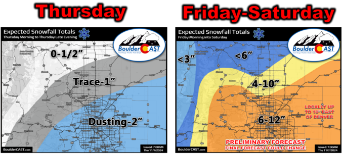
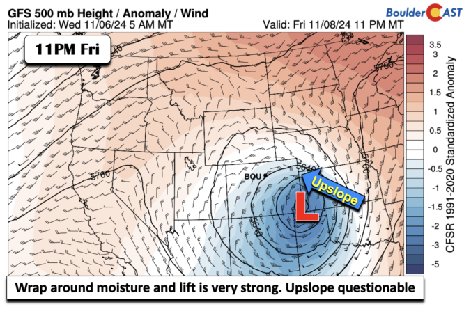
Our midweek system is not done yet. There are signals that as the system tracks to the ENE from New Mexico into far eastern Colorado and western Kansas Friday afternoon until midday Saturday will once again take aim on the Front Range. The NAEFS ensemble mean (which includes both the GEFS and GEPS ensembles) shows a deep and strong fetch …