Category: Premium Content (Page 251 of 452)

This content is for Premium Members only.

BoulderCAST Daily – Sun 10/25/20 | Strong winter storm still on track

Detailed Forecast Discussion: Temperatures as of earlier this morning had already dropped to the upper teens across the Front Range. This is much colder than expected 24 hours ago. Temperatures are only expected to drop further through the remainder of the day and tonight,  eventually falling to the single digits come late tonight/early Monday. Everything is still on track for …

BoulderCAST Daily – Sat 10/24/20 | Warmth before the snow!

Detailed Forecast Discussion: Lots to discuss in the next 24-36 hours as a very deep and impressive storm system sets the stage for a snowy Sunday and Monday, along with bitter cold to start our upcoming work week. Today, the mid-level system is over Montana (below left), with westerly flow present across Colorado. With the help of this downslope flow, …

BoulderCAST Daily – Fri 10/23/20 | Patchy freezing drizzle giving way to clouds and highs hovering in the 30’s

Detailed Forecast Discussion: After a cold start with overnight lows this morning in the 20's with freezing drizzle, be on the lookout for slick spots on the roadways and sidewalks if you are out and about for the morning hours. Some patchy freezing drizzle is likely for the start of the morning, but should give way to just overcast skies …

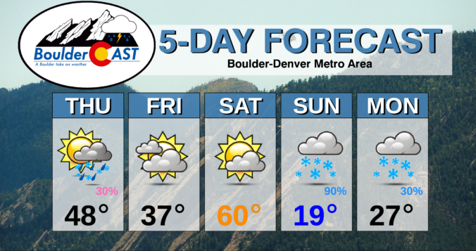
BoulderCAST Daily – Thu 10/22/20 | Prepare for light freezing drizzle & the first HARD freeze of the season tonight!

MDetailed Forecast Discussion: ild temperatures, low humidities, and gusty winds in the High County yesterday led to explosive growth of the East Troublesome Fire west of Grand Lake (and overnight, into Grand Lake..). Evacuations were issued and the massive plume of smoke without a doubt dwarfed any of the other Front Range fires during the day. Here's the view from …

BoulderCAST Daily – Wed 10/21/20 | Warm today, tumbling temperatures tomorrow

TDetailed Forecast Discussion: here is one more mild day to enjoy before the pattern really begins to shift for us tomorrow. The jet stream is currently located still to the north with flow across Colorado coming from just a hair south of due westerly. The position of the jet is shown below. Across the Pacific Northwest, a quick-moving, clipper-type storm …

BoulderCAST Daily – Sun 10/18/20 | Morning clouds and cold giving way to smoke

Detailed Forecast Discussion: Overcast skies start out our day today as the cold front has traversed through the region. Behind, northeasterly surface winds are present, along with an extensive area of low cloudiness all along the Front Range. These clouds will be slow to lift, but sunshine should start to take hold this afternoon. Some light drizzle will be around …

BoulderCAST Daily – Sat 10/17/20 | A quick warmup before colder air oozes down after midnight

Detailed Forecast Discussion: A strong mid-level trough is making its way through the state this afternoon and this evening, with a strong west-northwest flow (below left). As this trough passes through, clouds will be in and out across the Front Range as wave clouds develop east of the Divide. Gusty downslope winds last night have died down somewhat but will …

« Older posts Newer posts »