Category: Premium Content (Page 250 of 452)

This content is for Premium Members only.

BoulderCAST Daily – Tue 11/03/20 | Cloudier but still very warm

ADetailed Forecast Discussion: weak area of low pressure is currently located near Lake Tahoe with increasing moisture aloft flowing into Colorado ahead of this system from the southwest. With this, there will be more cloud cover around today...enough to produce partly to mostly cloudy skies through the afternoon into the evening. Highs will still be quite warm for early November …

BoulderCAST Daily – Sun 11/01/20 | Mild for the 1st of November

Detailed Forecast Discussion: Across the nation this afternoon, Colorado is under anomalously warm high pressure (below). The area of high pressure is situated to the east of a cut-off area of low pressure off the coast of southern California. To the east over the Great Lakes, a deep trough will be pushing into the northeast and southeastern U.S., with some …

BoulderCAST Daily – Sat 10/31/20 | A chilly cold front ushers in Halloween!

Detailed Forecast Discussion: In the upper levels of the atmosphere today, a trough across the upper Midwest will be advancing south and eastward through the afternoon hours. As it does so, winds aloft will become northwesterly instead of west, allowing cooler air to filter in. As a result of the trough passage, a nice cold front slides through around midday …

BoulderCAST Daily – Fri 10/30/20 | Staying mild, gusty tonight in the Mountains

ADetailed Forecast Discussion: pologies for the delayed discussion this morning. Andrew got wrapped forecasting flash flooding and tornadoes from the remnants of Hurricane Zeta in North Carolina late last evening. In any case, today's forecast will be rather calm in the Front Range. As promised, yesterday's high temperatures were quite variable across the Metro area, with locations melting away the …

BoulderCAST Daily – Thu 10/29/20 | Sunny for the next five days (at least)

ZDetailed Forecast Discussion: eta made landfall as a Category 2 Hurricane near New Orleans yesterday. The damage is still being assessed of course, but a direct strike in that particular area is never good due to a relatively high population density and extremely low-lying topography along the Mississippi River delta and Lake Pontchartrain. GOES infrared satellite imagery of the landfall …

BoulderCAST Daily – Wed 10/28/20 | A few degrees warmer, a few more clouds

TDetailed Forecast Discussion: he upper-low continues to spin to our south this morning with the center currently located across southeastern New Mexico. As you can see on the infrared satellite animation below from GOES-East, the outer edge of the cloud cover associated with the low is slipping northward into portions of the Metro area (click to zoom, look closely for …

BoulderCAST Daily – Tue 10/27/20 | A frigid morning, but warming up by afternoon

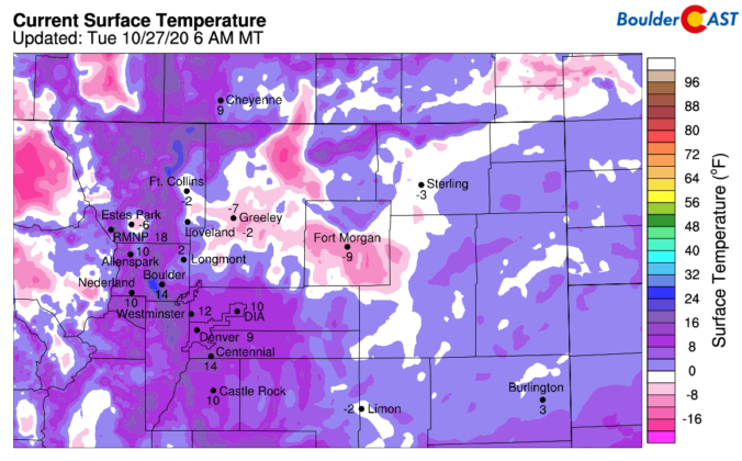
TDetailed Forecast Discussion: emperatures across the Denver Metro area are highly variable this morning with values well below zero in the lower elevations north and east, but a more modest 10 degrees or so around Boulder and Denver.  Localized low-lying areas will be colder, though. Terrain alone shouldn't cause this amount of separation between Fort Morgan and Boulder, for example. …

« Older posts Newer posts »