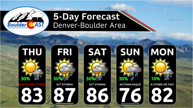
Monsoonal flow begins to push into parts of Colorado today from the south, enhanced somewhat by the long-dissipated remnants of Tropical Storm Eugene in the eastern Pacific Ocean. Moisture will just start to reach the Front Range today supplying enough moisture to form high-based convection this afternoon and evening, with gusty winds and light rain the main things to watch …
Supercell thunderstorms produced a track of destruction that lasted nearly 100 miles in eastern Colorado yesterday evening. Check out the slew of severe weather reports from Tuesday: Several strong tornadoes (EF2+) likely occurred in these areas. There were also numerous reports of softball-sized hail and even photos of DVD-sized hail up to 5" in diameter --- which if verified would …
Another day of widely scattered storms are expected across the Front Range as a shortwave traverses into Colorado from the northwest. This closed-shortwave can be seen in the 3km NAM 500mb vorticity animation below. It won't fully arrive until the nighttime hours, but there will be plenty of vorticity advection ahead of the trough to enhance storm development during the …
Afrontal passage has brought much cooler temperatures across the Front Range today. The temperature anomalies in the lower levels (below) range from 2 to 3 standard deviations below normal for early August. We'll see highs in the low to middle 70s before the threat of storms approach later this afternoon and evening. Speaking of storms, at mid-levels, we have a …
Asurface low to our northeast this afternoon will slowly drag a cold front into our region this evening, ushering in much cooler weather for tomorrow. At the same time, high instability this afternoon alongside a surface trough ahead of the front will increase our chances of showers/storms later today and tonight. The Storm Prediction Center has issued a slight risk …
The ridge of high pressure to our southeast starts to make a westward turn today. With a corresponding area of low pressure over Wyoming/Montana, that will result in a more westerly downslope flow today as opposed to southwesterly earlier this week. This will mean a drier trend to end our week with less storm chances this afternoon and evening. Highs …
Today begins a shift in our weather away from soaking monsoon thunderstorms towards a greater risk of severe storms, mainly for the eastern Plains of Colorado though. This shift is due to shutdown of the monsoonal pipeline, at least temporarily, as well as increasingly strong flow aloft which will aid in the shear needed for strong to severe storms. GOES-East …