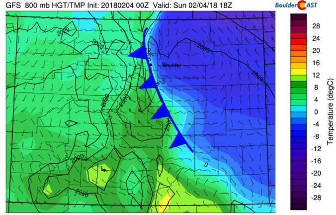
Yet another shallow Arctic front has backed into the Metro area this morning, with light snow and freezing drizzle now falling across the region. We detail the weather for the next 48 hours, including the chance of more wintry weather Monday night.
Category: Powdercast (Page 16 of 22)
Forecasts focused on the many ski resorts of NE Colorado.
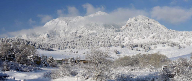
STORM UPDATE (Sunday 9:00 AM): Totals through 9:00AM are 3-5″ across the Plains and 4-6″ in the Foothills. Everything looks on track. Snowfall rates will be heaviest before noon today (up to 3/4″ per hour), with snow tapering off this afternoon from northwest to southeast as winds shift to downslope. Additional accumulations of 1-4″ are possible.
The impending winter storm is tracking slightly slower than the weather models were advertising yesterday. The impacts are good, if you like snow that is! We provide our final forecast, including timing, impacts, and our snowfall forecast map!
Warm weather has been the story over the last few days for the Front Range, but that headline is about to change with the arrival of a potent winter storm Saturday night. We explain the atmospheric set-up and detail what will likely be our biggest snow event so far this winter across the lower elevations.

We discuss the forecast for more snow Saturday night across the Front Range, and detail the locations that will see a White Christmas!
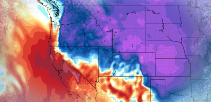
Accumulating snow and frigid temperatures are on the way for most of Colorado! Read on as we discuss the arrival of the first Arctic cold front of the season, one which has good timing to coincide with the winter solstice on Thursday.
The month of November wrapped up as the second warmest on record in Boulder. During the month, we had ten 70+ degree days, but only one with a high temperature below 40 degrees. The remarkable warmth of late will NOT continue for the week ahead, unfortunately. Continue reading as we detail the forecast for the next seven days.

This week’s weather will be rather tranquil, with temperatures overall above average for this time of year. However, we are watching a cold front for Wednesday and a trough late in the week that could bring snowfall to the region. We detail all this and more in our weekly outlook for the third week of November.

Temperatures are climbing to near-record levels into the low 80’s this afternoon. Would you believe that by this time tomorrow we’ll be 40 to 50 degrees colder with snowflakes flying? That is the situation at hand as a quick-moving storm system is set to clip eastern Colorado. Read on for details.

Live View of Boulder

Current Conditions

Live Radar

Recent Premium Posts

BoulderCAST Daily – Fri 11/07/25 | Quiet conditions – still no snow
🌡️ Mild temperatures: Mild in the lower 60s 💨 Cold front brings us …
This Weekend in Colorado Weather: Red Flag Conditions Thursday, a cooler weekend ahead, and chances increase for a record late first snowfall
🔥 Windy with fire danger Thursday: Gusts of 20–30 MPH across the Metro …
October 2025 Graphical Weather Review: A warm & dry month that prolonged the growing season, delayed our first snow
October 2025 was definitively warm and dry throughout the Front Range with the …
3-Day Forecast

LATEST SMOKE FORECAST

Trending Content


© 2025 Front Range Weather, LLC