Happy Labor Day! This week will feature wildfire smoke building back into the region causing visibilities to deteriorate, especially Monday through Wednesday. With the exception of Tuesday, most of the week will see above average temperatures, even potentially record-breaking ones late in the week. All is dry, though unsettled weather increases over the upcoming weekend into early next week.
Category: Long-Range (Page 5 of 15)
If you can believe it, Friday’s high temperatures was only in the 70’s across the lower elevations. What a gorgeous day! However, the brief cooldown will quickly be replaced by yet another heatwave in Front Range Colorado. This one will be stronger and longer than the last. Let’s discuss just how hot it will get, our concerns about new wildfires, and when the heatwave may finally relax.

Summer 2021 Outlook: La Niña is dead, but that may not necessarily bode well for Colorado’s drought or the fire season ahead
There’s no doubt about it. The La Niña pattern that developed late last summer is now dead. There’s no need to mourn this loss as this is actually good for Colorado and bodes well for a more active monsoon season this summer…or does it? Let’s take a look at the current state of ENSO and the weather outlook for the coming months.
After a bitter cold stretch under the fringes of the Polar Vortex, a “relative” warming trend develops this week but we still remain largely below average. By mid-week a cold front will bring the return of light snow to the area. Week’s end may turn breezy and finally near normal with potential Chinook winds developing. Let’s dig into the details.
This week’s snow event, while certainly welcomed, is not nearly enough not help the ongoing extreme drought across the entire state of Colorado. With a dry stretch shaping up through the weekend ahead, Boulder will most likely polish off January with its 7th consecutive month of below normal precipitation. We recap the recent “snowstorm”, discuss the current state of the drought, update you on the evolving La Niña, and provide our prediction for what lies ahead the rest of winter.
After a breezy last couple of days, the holiday week starts out calm and mild for the first official day of winter. A midweek cold snap will ensue, along with a slight chance of snow showers. The Christmas forecast is looking dry, although there are signs that a more active pattern could develop for late December.
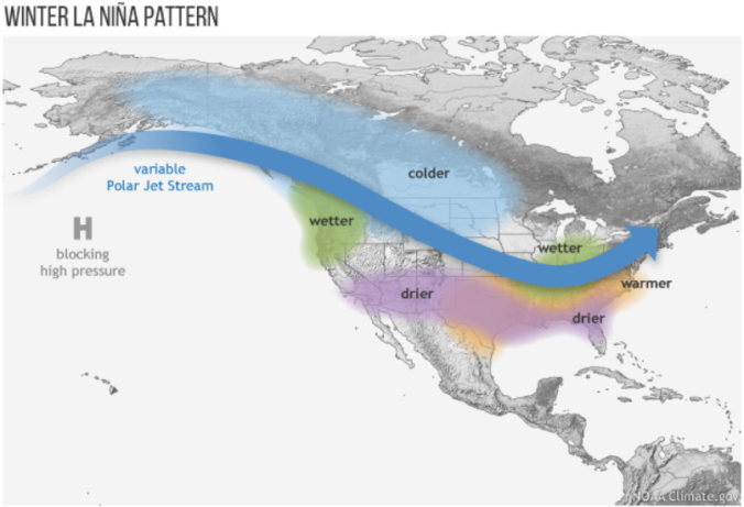
For the first time in three years, La Niña conditions have developed and are expected to last through the upcoming winter. We discuss the forecast, remind you what La Niña actually is, and explain the potential impacts La Niña will have on Colorado for the rest of autumn. If you like pie charts, box-and-whisker graphs and/or 3-D representations of ocean temperatures, this post is most definitely for you!
What are our predictions for the rest of fall and the snowfall potential this winter as La Niña takes hold? What happened in the Front Range during the last few La Niñas? Does 2020’s hurricane season so far hold a candle to the hyper-active one back in 2005? Listen to find out!
© 2026 Front Range Weather, LLC


