This week will feature a mixture of calm and chaos in Front Range Colorado! While the early part of the week will be relatively quiet with cool temperatures, a significant change in our weather is brewing for Friday. An Arctic blast is set to slam eastern Colorado during the late-day period, ushering in the coldest air of the season this weekend alongside widespread snowfall. Enjoy the sunshine and mild conditions the next several days, but begin preparations for the deep freeze and snowy conditions ahead!
Category: Long-Range (Page 3 of 16)
This week’s weather in the Front Range will see a shift from the recent unseasonably warm temperatures to cooler conditions, with periodic light snow expected in the Mountains throughout the week. While a white Christmas is unlikely for the Denver Metro area, there will be a slight chance of rain or snow showers Wednesday evening and night. The late-week period will remain active with several disturbances bringing more light snow to the Mountains, but the lower elevations around Boulder and Denver will stay mostly dry with mild temperatures. We also look ahead to next week when we’ll likely see a longer-term transition to much colder and snowier weather for the New Year.
Get ready, Colorado! The first snowflakes and a hard freeze of the season are on their way as this dramatic shift in weather across the state continues. Better late than never, right? We discuss when the snow will begin, how much could stick on the grassy surfaces, and when to expect the end to the 2024 growing season as temperatures are sure to plummet below freezing. We’re also tracking another potential snow event early next week. Here’s the latest.
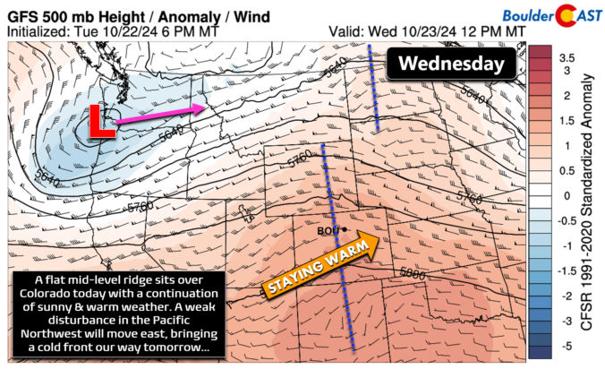
The Front Range will unfortunately see a continuation of unseasonably warm and bone dry weather this week. With a strong ridge of high pressure parked over the region, temperatures will remain summer-like in the lower 80s for the most part. While a couple of weak cold fronts may bring slight temperature drops, there will not be any precipitation. Wildfire smoke from neighboring states will intermittently affect our air quality. We also look ahead to a pattern shift next week which should bring welcomed changes. Read on for all the details.
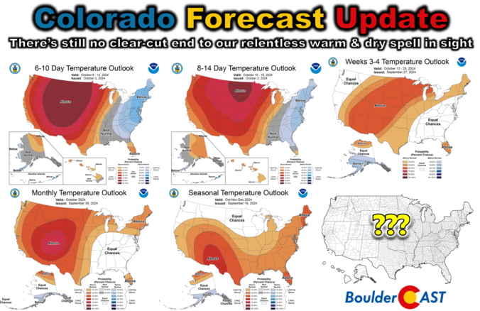
Colorado Forecast Update: There’s still no clear-cut end to our relentless warm & dry spell in sight
The Front Range is experiencing an exceptionally quiet and warm early autumn weather pattern that is expected to persist through the weekend and into next week. This prolonged dry spell is due to a stubborn ridge of high pressure over the southwestern United States, preventing any significant weather systems from reaching Colorado. Despite a couple of weak cold fronts, temperatures will remain well above normal throughout the extended, with record highs possible on Saturday. Unfortunately, there is no significant rain or snow in the pipeline, exacerbating the ongoing drought and increasing fire danger across the region. Here’s the latest on what is becoming a dire situation.
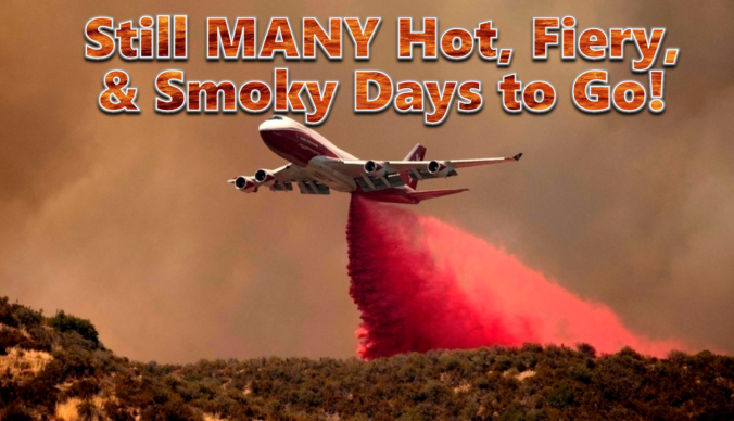
Between the extreme heat, thick smoke and new wildfire ignitions, this week has been quite the disaster in the Front Range! Our fuels have been primed for weeks now and our team has been vocal regarding this inevitable outcome, but things unravelled much quicker than even we expected this week with something like ten wildland fires in the Front Range just since Monday, in total burning more than 9,000 acres of forest! The weekend unfortunately won’t offer much reprieve from the heat, fire or drought, but we are tracking a potential shift next week towards wetter and cooler conditions. We provide an update on the local fires, the ongoing heatwave, the widespread smoke, and when actual raindrops may return to the forecast.

An impending pattern shift is expected to bring record-breaking triple-digit temperatures to the Front Range this weekend. This latest round of extreme heat is due to a superheated airmass moving into Colorado from the Desert, an airmass which has already produced all-time record highs in other western states. We review the climatology for rare triple digit heat, discuss why Denver is often several degrees warmer than Boulder during the summer, go over the forecast for just how hot it will get this weekend and look ahead to when we may finally cool off.

Live View of Boulder

Current Conditions

Live Radar

Latest Smoke Forecast

Recent Premium Posts

BoulderCAST Daily – Sat 07/11/26 | Here comes the heat!
🥵 Heat start today: Upper 90s start today and continue well into next …
BoulderCAST Daily – Fri 07/10/26 | The heat builds into the weekend
⛈️ Storms around today: A weak impulse of energy favors some isolated storms …
BoulderCAST Daily – Wed 07/08/26 | The Front Range Has Broken Out of the Haze — Storms Fire After Noon
🌬️ Smoke has (mostly) cleared out: Westerly flow pushed the thick plume south/east, …
3-Day Forecast

Trending Content

© 2026 Front Range Weather, LLC