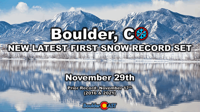
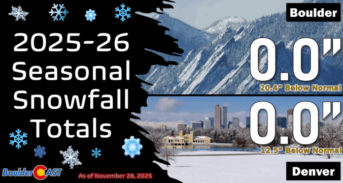
Boulder’s long snow drought has finally ended—just shy of a record streak. An Arctic front swept through early Saturday, dropping temps fast and delivering the season’s first flakes. Boulder picked up 0.3″, the latest first snowfall ever recorded in the city and it wasn’t even close. Curious how our forecast stacked up and what’s next? Spoiler: Another round of snow is already knocking on the door for Sunday.
Category: Forecast (Page 4 of 164)
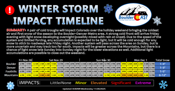
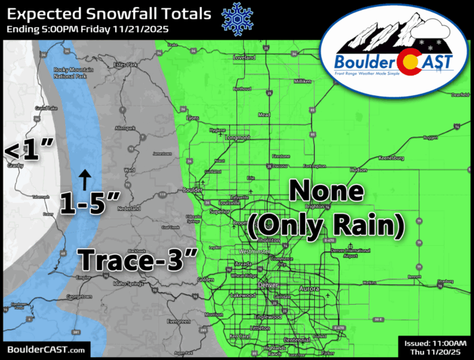
A big change is about to hit Front Range: after one more warm, breezy Friday, a strong cold front sweeps in overnight, dropping temperatures to the coldest of the season. Will Denver and Boulder finally see their first snow? That’s not guaranteed, unfortunately, but the Mountains are in for several fluffy inches and tricky travel ahead. Read on for the full breakdown—including details on the timing, our snowfall map, travel impacts and what lies ahead for our next wintry system on Sunday.
After weeks of unseasonable warmth, the Front Range is staring down its first taste of winter. Mild weather will continue for the next few days, including a beautiful Thanksgiving holiday, but by Friday night a powerful cold front will surge into Colorado, ending this historic snow drought with our first flakes of the season likely to fall. Read on for a full breakdown of what to expect and when, including our preliminary snowfall forecast map for Friday night.
As we wrap up November and head into Thanksgiving week, the weather is serving up a mix of calm and intrigue. The lead up to the holiday will be pleasant enough, but there are growing signs of a big pattern shift waiting in the wings. Could Arctic air and long-awaited snowflakes finally arrive by the weekend? The details are still coming into focus, but we’ve got the latest outlook and what it could mean for your holiday weekend plans.
It’s been a tricky week for the weather models — and for us forecasters trying to make sense of it all. Our latest storm system has kept everyone on their toes, thanks to a complicated dance between two low-pressure systems across the Southwest. Each new model run seemed to rewrite the story, with big swings in outcomes and plenty of disagreement between guidance. But now that the storm is closing in, confidence is finally improving: we’re looking at a light precipitation event for the Front Range, with rain the only worry across the lower elevations.
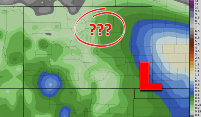
Enjoy Wednesday’s sunshine while it lasts—it’s the calm before a complicated storm setup arrives tomorrow. A pair of low‑pressure systems are set to interact in a complicated manner late Thursday into Friday, leaving big questions about how exactly things will unfold across eastern Colorado. Read on for our latest thoughts on the developing late-week autumn storm headed for the Front Range.

After weeks of unseasonable warmth and bone‑dry skies, the Front Range is finally staring down a pattern shift this week. But will it deliver the moisture we’ve been waiting for—or just more wind and disappointment? In this update, we break down some stats from our parched autumn so far, and take a look at several storm systems moving through Colorado this week, one of which will offer an excellent chance of rain (and maybe some snow) in the Boulder-Denver area.
This week brings a stretch of unseasonably warm and quiet mid-November weather across the Front Range, with highs holding in the upper 60s to low 70s through Friday. However, a stronger cold front arrives in time for the weekend and it could finally deliver a shot of snow. Models remain split on the system’s track, leaving the Metro area with only modest odds to see accumulating snow, while the Mountains look primed for several inches. With records for Boulder’s latest first snowfall and longest snow‑free streak hanging in the balance, this is a setup worth watching as the week unfolds.

Live View of Boulder

Current Conditions

Live Radar

Recent Premium Posts

BoulderCAST Daily – Tue 02/10/26 | Much cooler for our Tuesday with rain/snow arriving into the Mountains by Wednesday morning
🌡️ After Monday’s 70° warmth, a late‑night cold front has brought an end …
BoulderCAST Daily – Sun 02/08/26 | Mild for Super Bowl Sunday
☀️ Mild through Monday: Highs in the mid 60s to low 70s through …
BoulderCAST Daily – Sat 02/07/26 | A few wave clouds today but still quite mild
☀️ Mild through the weekend: Highs in the mid 60s to low 70s …
3-Day Forecast

Trending Content

© 2026 Front Range Weather, LLC