Category: BoulderCAST Daily (Page 63 of 465)

This page contains an index of our BoulderCAST Daily forecast updates. If you are NOT a Premium member, you will only see a tiny sample of this content below. Subscribe to BoulderCAST Premium to gain access to all of our daily forecasts which get published every morning.
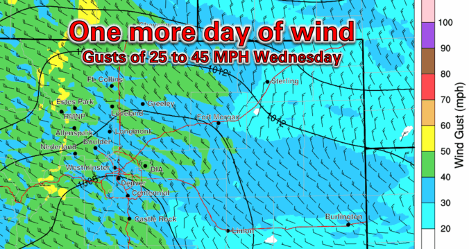
Premium BoulderCAST Daily – Wed 05/21/25 | A bit warmer & windier today, rain chances increase for the holiday weekend

Today will play out a lot like yesterday, except it will be a few degrees warmer and the winds a few ticks stronger. Infrared satellite imagery shows the continued flow across the area from the west-northwest this morning. There are a few spotty clouds around now, and that will remain the case through the day, but no rain is to …

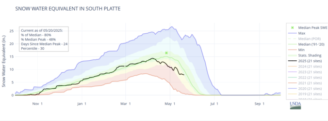
Premium BoulderCAST Daily – Tue 05/20/25 | Gusty sunshine the next few days, plus an update on regional drought & snowpack

TGusty sunshine the next few days he trough that caused severe storms on Sunday, as well as Monday's cool and gloomy weather, has moved out of our area overnight. In its wake, drier northwest winds have taken over across Colorado. This setup will stick around today and tomorrow, bringing sunny skies but also gusty winds. Meanwhile, the same trough continues …

Premium BoulderCAST Daily – Sun 05/18/25 | Enhanced Risk of severe storms mainly east of Denver this afternoon and tonight

The right ingredients are coming into place for an enhanced risk of severe storms this afternoon and evening. A strong trough will become negatively-tilted by the early evening hours. This will set the stage for intense lift and energy to allow for storms to blossom over east and northeast Colorado later today and tonight. Moisture will be present, but also …

Premium BoulderCAST Daily – Sat 05/17/25 | Isolated to scattered showers/storms through the weekend, with severe potential Sunday

Temperatures will hover in the lower 70s through the weekend. We will also have the chance of pockets of isolated spotty showers this afternoon and evening. Today, that chance is pretty minimal, with most activity being benign overall. A better chance of some scattered afternoon and evening storms will come with a negatively-tilted trough that will round the base of …

Premium BoulderCAST Daily – Fri 05/16/25 | Right at average for highs with unsettled weather later this weekend

The trough that affected us the past few days is moving out, heading for the Minnesota region this afternoon. However, we will still be influenced by the departing trough with northwest flow persisting through this afternoon. High temperatures will top out around 70, very much near normal for the middle of May. That northwest flow will favor another gusty afternoon …

Premium This Weekend in Colorado Weather: Breezy and dry to end the week, but late-day rain returns in the extended

YRain review esterday’s rainfall turned out to be heavier than expected, as a developing line of thunderstorms along the cold front shifted about 50 miles farther south than forecasted. This brought widespread rain to areas north of Interstate 70. The animation below shows the radar activity from early Wednesday evening. Some storms produced small hail and strong outflow winds, with …

Premium BoulderCAST Daily – Wed 05/14/25 | Beautiful through early afternoon, but trending cooler and gusty thereafter with a chance of rain

Today marks a shift in the weather across the Front Range, transitioning from the summer-like warmth of recent days to a cooler, more unsettled pattern for the latter half of the week. The driving force behind this change is a Pacific trough moving in from the northwest, set to cross the Rockies—including Colorado—later today. Satellite imagery indicates the trough's axis …

« Older posts Newer posts »