Category: BoulderCAST Daily (Page 31 of 370)
This page contains an index of our BoulderCAST Daily forecast updates. If you are NOT a Premium member, you will only see a tiny sample of this content below. Subscribe to BoulderCAST Premium to gain access to all of our daily forecasts which get published every morning.
Light but fluffy snow is falling across the entire Front Range this morning. In today’s update, we take a look at current travel conditions around the area, how much snow has already fallen and what is still to come based on the latest model data. Plus a look at just how cold it will get for the night ahead with clearing skies and fresh snow on the ground.
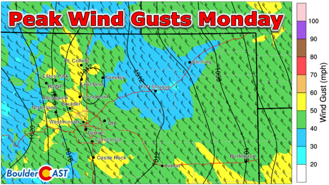
Westerly winds will quickly ramp up Monday morning with widespread gusts of 40 to 60 MPH expected across much of eastern Colorado today. While the latest model runs have indeed weakened the forecasted winds somewhat, fire danger will definitely be elevated through the day. We review the latest model data and provide an update on how the high winds, Mountain snow, and fire risk will unfold on Monday.
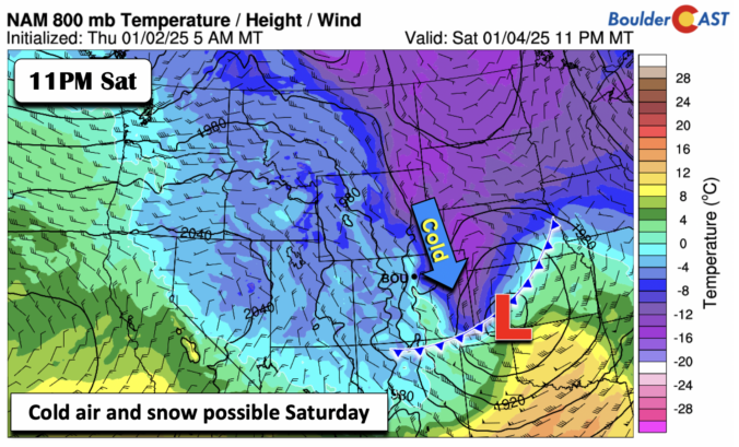
NOTE: Due to the ongoing weather event, our usual weekly outlook forecast will be posted on Tuesday this week. Check back then for a broader outlook of the next five days.

Live View of Boulder

Current Conditions

Live Radar

Recent Premium Posts

BoulderCAST Daily – Sat 11/08/25 | Turning chillier tonight and Sunday
🌡️ Turning chillier tonight: Cooler highs in the middle 50s. We turn colder …
BoulderCAST Daily – Fri 11/07/25 | Quiet conditions – still no snow
🌡️ Mild temperatures: Mild in the lower 60s 💨 Cold front brings us …
This Weekend in Colorado Weather: Red Flag Conditions Thursday, a cooler weekend ahead, and chances increase for a record late first snowfall
🔥 Windy with fire danger Thursday: Gusts of 20–30 MPH across the Metro …
3-Day Forecast

LATEST SMOKE FORECAST

Trending Content


© 2025 Front Range Weather, LLC