Category: BoulderCAST Daily (Page 267 of 465)

This page contains an index of our BoulderCAST Daily forecast updates. If you are NOT a Premium member, you will only see a tiny sample of this content below. Subscribe to BoulderCAST Premium to gain access to all of our daily forecasts which get published every morning.

BoulderCAST Daily – Thu 09/10/20 | Mostly cloudy with isolated flurries/sprinkles

TDetailed Forecast Discussion he pesky upper-low continues to spin across southeastern Utah and slowly fill. The term "fill" is something we use to describe a weakening storm system that is literally "filling with air" causing the pressure of the low to rise and thus weaken. GOES-East water vapor imagery shows the rather stagnant storm system to our west. This remnant …

BoulderCAST Daily – Wed 09/09/20 | Morning flurries, remaining unseasonably cold

MDetailed Forecast Discussion ost of our area ended up dodging a bullet with snow totals coming in on the lower end of the spectrum. Boulder reported nearly 5" of heavy wet snow with this wintry system. This wasn't the earliest occurrence of snow in Boulder, but it was indeed the earliest accumulation on record. The view from the webcam downtown …

BoulderCAST Daily – Mon 09/07/20 | Happy Labor Day!

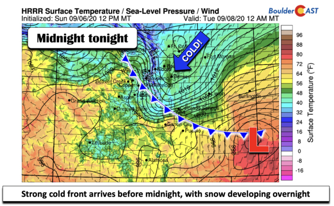
Detailed Forecast Discussion Happy Labor Day! Today is our last day of near 90 degree temperatures, as a very strong low pressure and associated cold front dive down late tonight, bringing our first significant snow very early in the fall season! For this afternoon, temperatures will rise to the upper 80's to around the low 90's as the airmass is …

BoulderCAST Daily – Sun 09/06/20 | Hot and smoky today…Cold and snowy after Labor Day

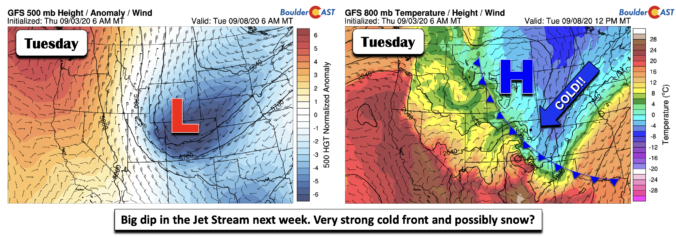
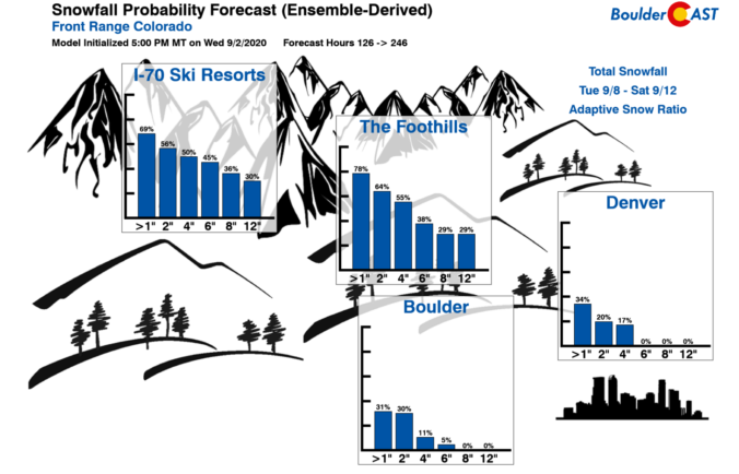
Detailed Forecast Discussion First off, happy Labor Day weekend, hope that your extra day off tomorrow is safe and wonderful! Quite amazing change in the weather to occur between today and tomorrow night as strong ridge of high pressure transitions westward to allow for a deep and impressive trough to dig down from Canada into Utah/Colorado Labor Day tomorrow into …

BoulderCAST Daily – Sat 09/05/20 | Mid to upper 90’s today…snow and cold after Labor Day

Detailed Forecast Discussion There is going to be quite the swing in temperatures and overall weather over the next 48-72 hours. With near record heat today, temperatures will plummet after Labor Day with the potential of snow. Before we discuss that, below shows the 700 mb (5,000 feet up) temperatures. Near record heat can be expected today with mid to …

BoulderCAST Daily – Fri 09/04/20 | Back into the 90’s this holiday weekend

Detailed Forecast Discussion Big changes to be occurring in the weather both this holiday weekend and early next week after Labor Day. After yesterday's highs in the middle 80's, temperatures will be going back into the 90's starting today, and middle 90's tomorrow and Sunday. The record highs for tomorrow for Boulder and Denver are 97 and 98, respectively. We …

BoulderCAST Daily – Thu 09/03/20 | Slightly cooler today, a heat wave this weekend, and snow next week?!

QDetailed Forecast Discussion uiet weather will remain across the Front Range through the rest of the week. A cold front pushed through during the overnight last night which will lead to a slightly cooler day today for the area. From the surface observations at BoulderCAST Station, we can see that the cold front moved through just before 4:00AM with gusty …

« Older posts Newer posts »