Category: BoulderCAST Daily (Page 263 of 465)

This page contains an index of our BoulderCAST Daily forecast updates. If you are NOT a Premium member, you will only see a tiny sample of this content below. Subscribe to BoulderCAST Premium to gain access to all of our daily forecasts which get published every morning.
BoulderCAST Daily – Tue 10/13/20 | A great October day, but a gusty front arrives tomorrow

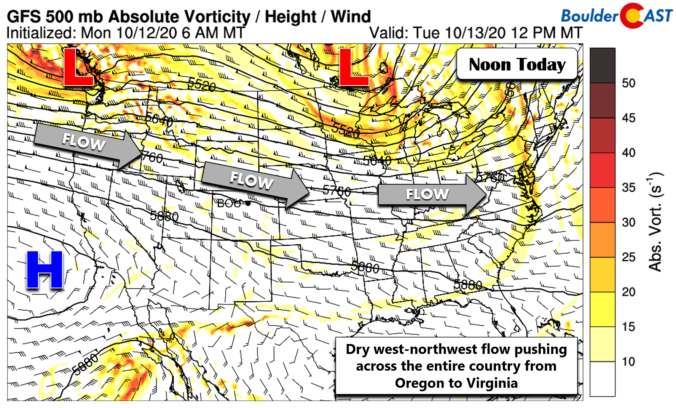
HDetailed Forecast Discussion: appy Tuesday! Outside of a few mountain wave clouds yesterday, we got unobscured views of the fresh snow in the Mountains that fell on Sunday from GOES-16. The animation during the day yesterday is shown below. As we detailed in our weekly outlook, today will be another rather uneventful weather day across the state with predominantly dry …

BoulderCAST Daily – Sun 10/11/20 | Breezy and cooler

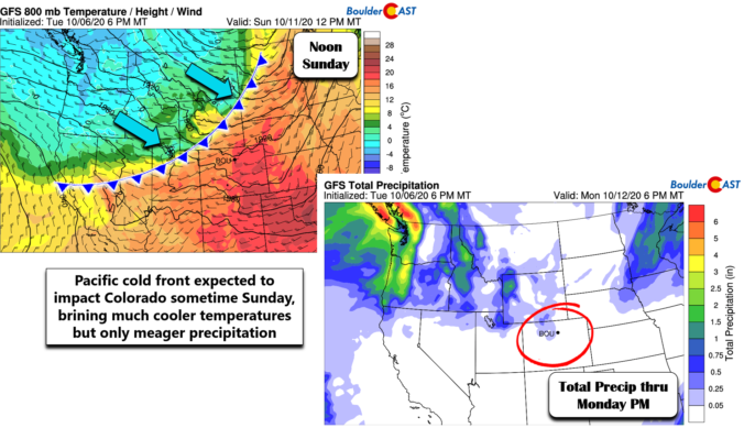
Detailed Forecast Discussion: Strong cold front has pushed through Colorado. The real cold air though is slow to ooze in, fully building in by this evening across the Front Range. Plenty of cold air though in the High Country, with northwest flow along and west of the Divide. That will allow for good snow chances from Steamboat into Winter Park, …

BoulderCAST Daily – Sat 10/10/20 | Last 80+ degree day before a sharp drop

Detailed Forecast Discussion: We have one last 80+ degree day (or so we think) before the temperature drops tomorrow behind a very strong and fast moving cold front. The front has made its way into the Pacific Northwest, with below freezing temperatures in that direction at about 10,000 feet off the ground (below). Over us, we are still under the …

BoulderCAST Daily – Fri 10/09/20 | Milky and hazy sky with highs in the 80’s

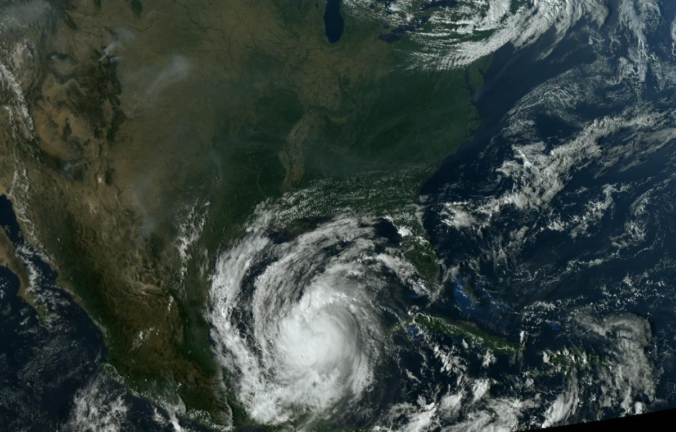
Detailed Forecast Discussion: Some interesting weather features to discuss from this morning's satellite image below. Hurricane Delta makes landfall later today over southern Louisiana, a very similar landfall position as Laura earlier this year. Over us, we are in the westerlies with a weak mid-level disturbance tracking west to east across the state. An area of low pressure exists offshore …

BoulderCAST Daily – Thu 10/08/20 | Sunny & smoky with near-record warmth

WDetailed Forecast Discussion: arm, mostly sunny and dry conditions will reside across the Front Range through Saturday with highs in the 80's. The biggest forecasting challenge in the coming days surrounds the lingering smoke loaded into the atmosphere across much of Colorado. Of course the massive fires burning to our northwest will continue to produce billowing smoke plumes each afternoon …

BoulderCAST Daily – Wed 10/07/20 | High pressure is on top of us

BDetailed Forecast Discussion: oulder snatched up yet another record in 2020 yesterday soaring to a new historical daily high of 86°F. Little changes will occur in the forecast today as the center of high pressure is now situated directly over Colorado. Essentially we're looking at an identical airmass and conditions to what we saw on Tuesday. The only change worth …

BoulderCAST Daily – Tue 10/06/20 | Record highs possible though not likely through Saturday

IDetailed Forecast Discussion: f you recall from our weekly outlook posted yesterday, the ridge axis to our west was oriented northwest to southeast across the Four Corners region. Today, the ridge is showing initial signs of weakening as it flattens out, now lined-up almost directly west to east. This flattened ridge will continue to slide eastward in the coming days. …

« Older posts Newer posts »