


Category: BoulderCAST Daily (Page 105 of 465)

This page contains an index of our BoulderCAST Daily forecast updates. If you are NOT a Premium member, you will only see a tiny sample of this content below. Subscribe to BoulderCAST Premium to gain access to all of our daily forecasts which get published every morning.
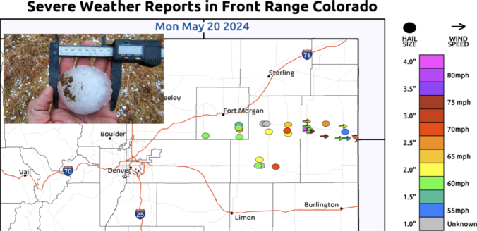
Premium BoulderCAST Daily – Tue 05/21/24 | Another round of storms today, but nothing like the severe outbreak that unfolded to our east last evening!

The shortwave trough which largely fueled yesterday's severe weather outbreak in northeast Colorado is exiting the far eastern corner of the state this morning. Current radar imagery shows the last of the associated rainfall shield departing into Kansas and Nebraska as well. Most of the Front Range picked up a light round of rainfall overnight --- generally about 0.1" in …

Premium BoulderCAST Daily – Sun 05/19/24 | A warm and dry downslope flow returns us to the lower 80s

Awarm and dry downslope flow out of the southwest today will create dry and much warmer conditions this afternoon. An area of low pressure in Montana will be a player for tomorrow, but we are largely quiet today. Warm temperature anomalies will send us back into the lower 80s for our Sunday, a great way to end the weekend. A …

Premium BoulderCAST Daily – Sat 05/18/24 | A chance of some late-day isolated storms with highs near 80

Aweak cold front has pushed through, and, behind it, easterly flow has ensued. This won't prevent us from warming nicely into the upper 70s to perhaps close to 80. But it will bring a chance of scattered late-day and evening storms. That chance will be tied to an upper-level wave that will track through in the southwest flow aloft. This …

Premium BoulderCAST Daily – Fri 05/17/24 | Warm and dry with lower 80s

Awarm and dry southwest flow will persist today to end our work week. High pressure over the central/southern Plains and a cold front approaching from the Pacific Northwest will set up a good warm advection regime over the state. Lots of sunshine will bring highs into the lower 80s this afternoon. There is no chance of storms today given dry …

Premium This Weekend in Colorado Weather: Largely quiet & warm weather under a split-flow pattern, but early next week may turn active again

There were fairly widespread raindrops yesterday in the Denver Metro area which led to up to 0.5" of rainfall in some locations. Most of the storms on Wednesday formed after dark and hit areas along and south of Interstate 70, though Broomfield/Westminster also caught some needed rainfall as well. A generally quiet next few days are expected for the Front …

Premium BoulderCAST Daily – Wed 05/15/24 | Cooler today with scattered thunderstorms, but warmer and drier in the days ahead

An active weather pattern currently sits across most of the contiguous United States, including here in Colorado. While the nation is lacking any truly strong storm systems right now (no major severe outbreaks, mid-latitude cyclones, cold air infusions), there are plenty of embedded shortwave features and small cut-off low pressures. One such shortwave is entering Colorado from this northwest this …

Premium BoulderCAST Daily – Tue 05/14/24 | Unsettled weather continues with scattered late-day gusty storms, some may produce severe wind gusts

Atightly-packed shortwave disturbance is sliding across Wyoming today -- notice the rotating vorticity max visible on this morning's GOES-East water vapor animation below. Though the bulk of the energy from this shortwave will pass north of Colorado, there is some trailing energy extending southward that will aid in the threat of showers and storms for us later today and tonight. …

« Older posts Newer posts »
