After a stretch of December warmth so extreme it rewrote some record books across the Front Range, we’re finally staring down a pattern shift—though not quite the snowy one we initially hoped for. A pair of cold fronts will bring a sharp temperature drop, a few chances for rain and snow, and at least the feeling of winter back to Boulder and Denver. The details have changed quite a bit in the last 24 to 48 hours, but we’ll walk you through what’s still on the table, what’s no longer likely, and where a few surprises could still sneak in Saturday night.
Category: Climatology (Page 2 of 66)
These posts contain information about the long-term weather patterns of Boulder County. Potential topics may include 30-day weather outlooks, El Nino/La Nina, and seasonal forecasts. You will find less about the day-to-day weather, with more focus on longer trends and patterns.
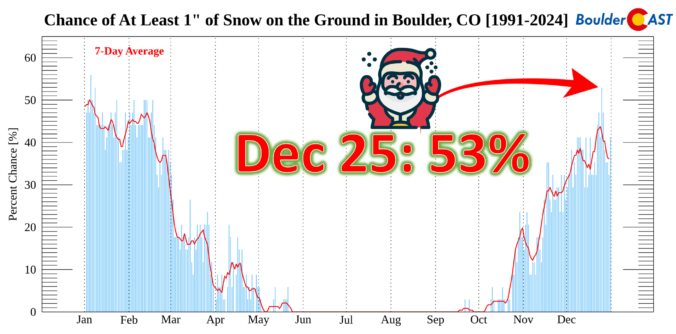
This Christmas will be a scorcher across the Front Range with temperatures soaring towards record highs near 70 degrees, but snow is often part of the equation here on Christmas, whether falling or on the ground. We take a broader look at White Christmas occurrences in Boulder’s historical record and discuss why Christmas Day, out of all days, has one of the highest probabilities of snow on the ground here.
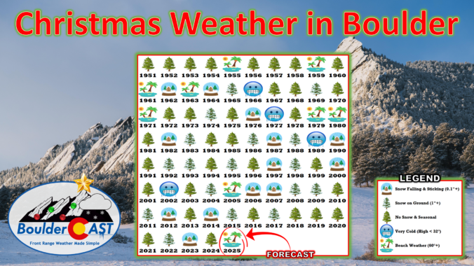
December has been anything but typical along the Front Range, with Boulder shattering warmth records and enduring weeks of bone‑dry weather that have fueled fire danger and stressed our local trees. As we head into Christmas, the holiday will feel more like patio season than sledding weather, with record highs likely and no snow available outside of the Mountains. But don’t pack away the winter gear just yet—a sharp cooldown and even a chance for light snow are on the horizon this weekend. We take a closer look this historically warm and dry December, the scorching Christmas forecast, and peek ahead to what’s next.
As we head into what’s normally the coldest stretch of the year along the Front Range, the atmosphere has other plans. Instead of Arctic air and snow globe conditions, we’re staring down a week of springlike warmth, fire weather concerns, and multiple shots at breaking long‑standing temperature records—including on Christmas Day. We’ll walk you through why this pattern is so unusual, what it means for Boulder and the Foothills, and where you can still find real winter this week if you’re craving it.
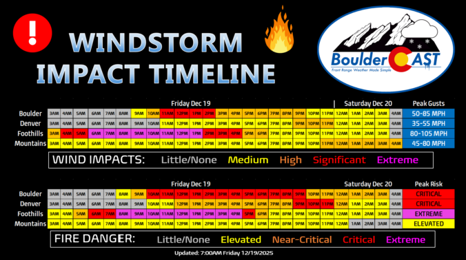
Updated (7AM Friday 12/19): Updated based on latest guidance adjusting timings and intensity of wind/fire impacts, and also made a stronger case for the extreme winds (and fire danger) to potentially stay mostly in the Foothills or very close to there. Lowered wind/fire risk in Boulder proper. This is still a very dangerous situation.
—
Boulder, the far western suburbs of Denver, and the Foothills are bracing for yet another powerful mountain wave windstorm Friday, with gusts likely topping 75–100 MPH and, this time, extreme fire danger will be layered on top. Forecast models show the strongest winds during the morning into the afternoon, coinciding with critically dry air and record‑challenging warmth. Power shutoffs, downed trees, and blowing dust are all on the table, but the bigger story is the fire risk—conditions are primed for rapid spread if any ignition occurs. Fortunately it now appears that most of the intense winds will stay largely in the Foothills, but there is some uncertainty how far downhill and east they will reach. Read on for the full breakdown of timing, impacts, and what you need to know to stay safe. We also briefly review the damaging wind event that just occurred on Wednesday.
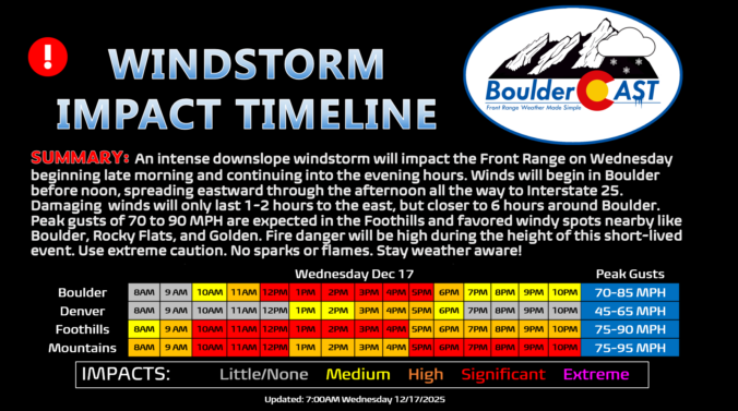
Hold onto your hats, Colorado—today’s forecast isn’t just another breezy afternoon. A fast‑developing mountain wave event is lining up to deliver some of the strongest winds we’ve seen in quite some time, with Boulder squarely in the bullseye for this event. We’re talking winds that can go from calm to extreme in minutes, near-critical fire danger with every gust, and even the likelihood of planned and unplanned power outages. Add in mountain snow squalls and a sharp cold front tonight, and it’s definitely a busy day in Colorado weather. Read on for the full breakdown of timing, impacts, and what you need to know to stay safe as the event unfolds.
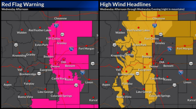
If you thought Monday’s sunshine was the start of a quiet week, think again. The next 48 hours will bring a dramatic shift in our weather —starting with breezy but pleasant conditions Tuesday, then escalating into a powerful downslope windstorm with heightened fire danger on Wednesday. And just when you think it’s wrapping up, a sharp cold front will crash the party with blustery conditions and even a chance for rain and snow Wednesday evening.
We’ll break down what to expect, where the strongest winds will hit, and how this event stacks up against the day of the Marshall Fire. Plus, we’ll look at the potential for Xcel power shutoffs (spoiler: it’s going to be happen).
The Front Range has been defined by relentless warmth, gusty winds, and bone‑dry conditions of late—and that theme isn’t breaking anytime soon. Even with a strong cold front charging through midweek, the cooldown will be pitiful, dropping us only back to “normal” while lasting only a single day, and it comes at the price of near‑critical fire danger beforehand. With highs hovering near or above 60° almost every day leading into Christmas and precipitation chances close to zero, a brown holiday is essentially guaranteed for the Boulder–Denver area. Read on for our full outlook of our weather heading into the holiday period.

Live View of Boulder

Current Conditions

Live Radar

Recent Premium Posts

BoulderCAST Daily – Tue 01/27/26 | Early morning clouds will give way to a sunny Tuesday
🌤️ Clouds Clearing Fast — Early morning mid‑level clouds from northwest flow fade …
BoulderCAST Daily – Sun 01/25/26 | Light snow develops later today into this evening
❄️ Light snow this afternoon and tonight: A fast-moving clipper type system brings …
BoulderCAST Daily – Sat 01/24/26 | Bitter Cold This Weekend With Light Snow Again Sunday
🥶 Arctic blast is here: Arctic Air lingers through the weekend with teens …
3-Day Forecast

Trending Content

© 2026 Front Range Weather, LLC