⦁❶⦁ Extremely dry air has overtaken the area today from the west
⦁❷⦁ Hot & dry will be the headline through Saturday
⦁❸⦁ Highs in the middle 90’s today with lots of sun
⦁❹⦁ Tropical Storm Cristina has formed off the western coast of Mexico and will help bring moisture northward to Colorado this weekend
Remember, our daily forecasts are Premium content. Periodically, we open this forecast up to all of our readers. Today is one of those days so please do enjoy!
Sign up today to get the best BoulderCAST experience, including these daily forecasts every morning, complete 6-day skiing and hiking forecasts, access of all our Front Range specific weather models, additional storm updates and much more!

Detailed Forecast Discussion
There is no use trying to sugar-coat this: it’s going to be another hot day today, tomorrow, and the next day…and the following handful of days after that. The heat is on across much of the country now with above normal readings expected across roughly 80% of the United States today, especially in Colorado.

Yesterdays’s shortwave helped produce some ominous looking skies, but little if any rainfall was reported in our neck of the woods. A few storms did develop further east across the Plains where moisture was more prevalent.

Observed rainfall amounts on Tuesday
As discussed yesterday, westerly flow aloft has brought in extremely dry air to Colorado with precipitable water values falling off a figurative cliff to near 0.3″ or lower in most areas this morning. This “bone-dry” airmass will be with us into Saturday morning leading to a complete suppression of any rainfall potential and also greatly reduced cloud cover in the coming days. The record low precipitable water value in Denver for today is 0.38″ which could be bested in this morning’s weather balloon launch, or even the one this evening. Dry air records could fall in Denver on any one of the next few days.

With no rain to speak of for the area, the story will once again be the scorching temperatures. Highs will climb into the middle 90’s again, with some upper 90’s possible to the east. Sunshine will be more widespread today with just patchy fair weather cumulus clouds developing this afternoon.

We have some good news and some bad news to share about tomorrow… First, the good news: we are tracking a slight cool-down for tomorrow! The bad news: it will likely only be into the lower to middle 90’s. This cool-down will be the result of a backdoor outflow boundary originating from thunderstorms in far northeast Colorado, western Nebraska and Kansas this evening. The rain-cooled air should push back westward into the Front Range during the overnight period making for a slightly cooler day tomorrow. It’s still going to be hot with above normal temperatures. It’s not a real break from the heat by any means.

HRRR forecast surface dew points today into tonight showing a moist outflow boundary surging westward into the Front Range originating from storms in Nebraska and Kansas
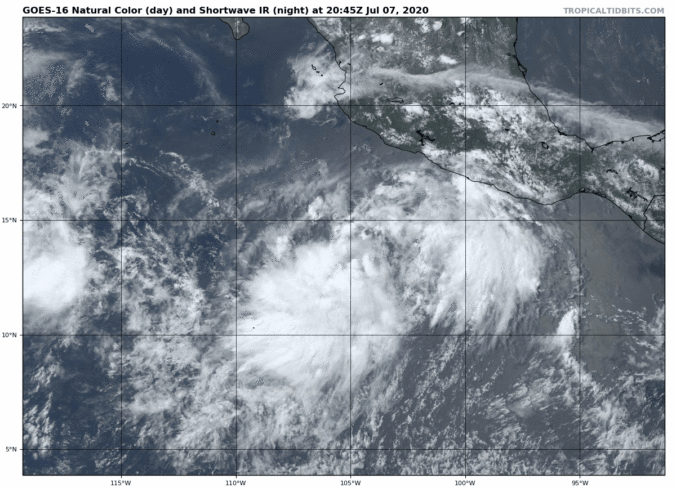
Finally, let’s talk about the tropics…the Eastern Pacific tropics that is. Tropical Storm Cristina formed yesterday and is projected to become a hurricane in the coming days heading northwestward away from Mexico. Similar to what happened with Tropical Depression 4E last week, Cristina will help draw subtropical moisture northward into Arizona and eventually Colorado sometime this weekend. It’s not going to be a substantial amount of moisture, but it should be enough dilute the very dry airmass in place now and bring a return of storm chances to the forecast. With any luck, we could see the first spotty storms on Saturday, but more than likely things will hold off until Sunday.

GOES-East satellite animation of Tropical Storm Cristina Tuesday evening

Tropical Storm Cristina is expected to track away from land and become a hurricane later today or tonight as it enters warmer waters.


You must be logged in to post a comment.