⦁❶⦁ Dry but remaining somewhat cool under northerly flow with highs in the middle to upper 70’s
⦁❷⦁ A broad ridge will spread into Colorado in the coming days with dry weather through Friday
⦁❸⦁ A heat wave along the West Coast won’t fully reach our area, but temperatures will warm nicely into the 80’s and eventually near 90 degrees
⦁❹⦁ The next 7 to 10 days look to be warmer than normal and largely dry for the Front Range
Do you want the latest BoulderCAST Daily forecast discussion delivered to your inbox every single morning? If so, join BoulderCAST Premium where we talk Boulder and Denver weather every single day.
Detailed Forecast Discussion:
Following a few scattered showers and thunderstorms yesterday, our weather will dry out in the coming days as a deep ridge of high pressure slowly builds into Colorado from the west. This will spread much drier air and strong subsidence to our region supporting calm weather and eventually warm temperatures. Today will still be somewhat cool as we remain under northerly flow between the strong ridge and a developing trough in the middle of the country. Highs will top out in the middle to even upper 70’s with clouds and sun. We can’t rule out an isolated shower or storm in the Mountains and Foothills, but the Denver-Boulder area stays dry.
Along the west coast, a very warm airmass is brewing with a widespread heat wave impacting that region. Look at all those heat and fire related highlights from the southern to northern borders of the country! Places like Boise, Merced, Las Vegas, Yakima, and Moab will all be near or above 100°F in the coming days.
As we discussed in our weekly outlook yesterday, the ridge will flatten out considerably by the time if fully reaches our state. This means no heat wave for us, but high temperatures will return close to 80° tomorrow and 80’s will likely continue into next week. Depending on the way things evolve, several days could be flirting with the 90° mark Saturday and beyond, but it’s too early to say if we’ll hit that mark for sure. The ensembles do indicate a lengthy warm stretch ahead!
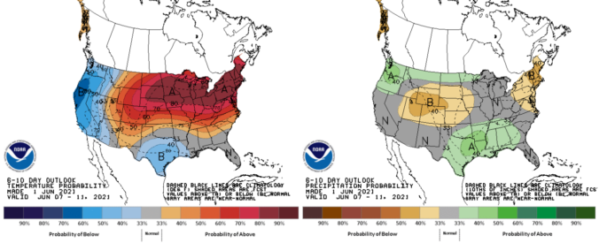
It does indeed look like we’ve finally kicked the cool and wet pattern across northern Colorado. There’s really not much going on in the medium-range models, outside of a few days with spotty late-day storms over the weekend. The Climate Prediction Center is forecasting warm and dry conditions for next week as a whole (June 7th – 11th) in the Front Range. Incredibly, most of us probably haven’t even turned on the air conditioner yet in 2021. That will change soon.
Remember, our daily forecasts are Premium content. Periodically, we open this forecast up to all of our readers. Today is one of those days!
Help support our team of Front Range weather bloggers by joining BoulderCAST Premium. We talk Boulder and Denver weather every single day. Sign up now to get access to our daily forecast discussions each morning, complete six-day skiing and hiking forecasts powered by machine learning, first-class access to all our Colorado-centric high-resolution weather graphics, bonus storm updates and much more! Or not, we just appreciate your readership!
.


You must be logged in to post a comment.