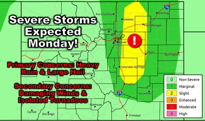
NOTICE: Due to unexpected travel, our usual weekly outlook discussion will be published a day later on Tuesday this week. Please check back tomorrow for the latest on Front Range weather. Early week weather highlights are as follows:
⦁❶⦁ A narrow plume of monsoon moisture will fuel numerous thunderstorms across the Front Range on Monday during the afternoon and evening
⦁❷⦁ Favorable shear will also be present increasing the risk for severe storms — heavy rainfall and golf ball-sized hail are the primary concerns, but damaging winds and a couple tornadoes also possible
⦁❸⦁ High temperatures reach the upper 80s in the afternoon before the storms cool us off
⦁❹⦁ Tuesday will be the only completely dry day this week as temperatures rebound back well into the 90s
⦁❺⦁ Thunderstorms will be in the forecast Wednesday and beyond with 30-50% chances each day
This content is for BoulderCAST Premium members only. Join Premium now to get access to our detailed forecast discussions for Boulder and Denver every single day, plus a bunch of other cool perks!
Daily Forecast Updates
Get our daily forecast discussion every morning delivered to your inbox.
All Our Model Data
Access to all our Colorado-centric high-resolution weather model graphics. Seriously — every one!
Ski & Hiking Forecasts
6-day forecasts for all the Colorado ski resorts, plus more than 120 hiking trails, including every 14er.
Smoke Forecasts
Wildfire smoke concentration predictions up to 72 hours into the future.
Exclusive Content
Weekend outlooks every Thursday, bonus storm updates, historical data and much more!
No Advertisements
Enjoy ad-free viewing on the entire site.


You must be logged in to post a comment.