Author: Ben Castellani (Page 6 of 294)
Ben grew up in southwestern Pennsylvania and holds both a bachelor's and a master's degree in Meteorology, the latter being from CU Boulder. His hometown received nearly three feet of snow from the Storm of the Century back in March of 1993, sparking his initial interest in impactful weather. Ben currently works on remote sensing and data analysis software at NV5 Geospatial Software in Boulder.
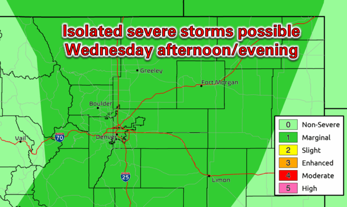
This week’s forecast is anything but boring in the Front Range. A fast-moving autumn storm is stirring up the atmosphere on Monday with jet-driven Mountain snow, powerful downslope winds, and a fire-weather setup that demands caution. And once the winds die down? A hard freeze will slam the door on the growing season for the entire area Monday night. Read on for a full breakdown of the very active weather unfolding in Colorado on Monday, plus a peek towards the quieter days ahead.

Live View of Boulder

Current Conditions

Live Radar

Recent Premium Posts

BoulderCAST Daily – Sat 01/10/26| Widespread sunshine and moderating temperatures this weekend as our recent snow melts off
🌤️ Calm Saturday: Winter storm systems have departed the state, leaving behind a …
BoulderCAST Daily – Fri 01/09/26| Snow ends quickly this morning with a quieter weekend in store
❄️ Overnight snow bands: A second push of upslope after midnight sparked narrow …
BoulderCAST Daily – Thu 01/08/26 | Snow develops today but still some uncertainty, amounts have been lowered
❄️ Snow develops today: Snow develops today, but uncertainty still lingers with two …
3-Day Forecast

Trending Content

© 2026 Front Range Weather, LLC