Author: Ben Castellani (Page 30 of 294)
Ben grew up in southwestern Pennsylvania and holds both a bachelor's and a master's degree in Meteorology, the latter being from CU Boulder. His hometown received nearly three feet of snow from the Storm of the Century back in March of 1993, sparking his initial interest in impactful weather. Ben currently works on remote sensing and data analysis software at NV5 Geospatial Software in Boulder.
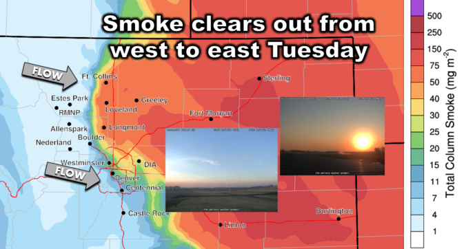
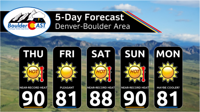
The Front Range will unfortunately see a continuation of unseasonably warm and bone dry weather this week. With a strong ridge of high pressure parked over the region, temperatures will remain summer-like in the lower 80s for the most part. While a couple of weak cold fronts may bring slight temperature drops, there will not be any precipitation. Wildfire smoke from neighboring states will intermittently affect our air quality. We also look ahead to a pattern shift next week which should bring welcomed changes. Read on for all the details.
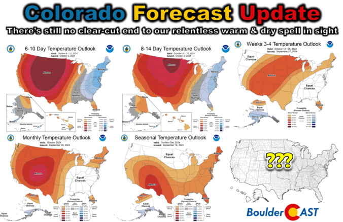
Colorado Forecast Update: There’s still no clear-cut end to our relentless warm & dry spell in sight
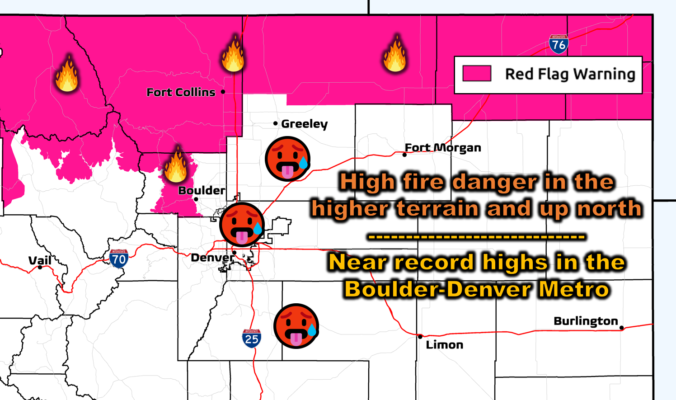
The Front Range is experiencing an exceptionally quiet and warm early autumn weather pattern that is expected to persist through the weekend and into next week. This prolonged dry spell is due to a stubborn ridge of high pressure over the southwestern United States, preventing any significant weather systems from reaching Colorado. Despite a couple of weak cold fronts, temperatures will remain well above normal throughout the extended, with record highs possible on Saturday. Unfortunately, there is no significant rain or snow in the pipeline, exacerbating the ongoing drought and increasing fire danger across the region. Here’s the latest on what is becoming a dire situation.

Live View of Boulder

Current Conditions

Live Radar

Recent Premium Posts

BoulderCAST Daily – Sun 01/11/26 | A mild Sunday with readings reaching the 50s
🌤️ Mild & Melty Sunday: Light winds and patchy clouds, with lingering snowpack …
BoulderCAST Daily – Sat 01/10/26| Widespread sunshine and moderating temperatures this weekend as our recent snow melts off
🌤️ Calm Saturday: Winter storm systems have departed the state, leaving behind a …
BoulderCAST Daily – Fri 01/09/26| Snow ends quickly this morning with a quieter weekend in store
❄️ Overnight snow bands: A second push of upslope after midnight sparked narrow …
3-Day Forecast

Trending Content

© 2026 Front Range Weather, LLC