
Author: Ben Castellani (Page 29 of 304)
Ben grew up in southwestern Pennsylvania and holds both a bachelor's and a master's degree in Meteorology, the latter being from CU Boulder. His hometown received nearly three feet of snow from the Storm of the Century back in March of 1993, sparking his initial interest in impactful weather. Ben currently works on remote sensing and data analysis software at NV5 Geospatial Software in Boulder.
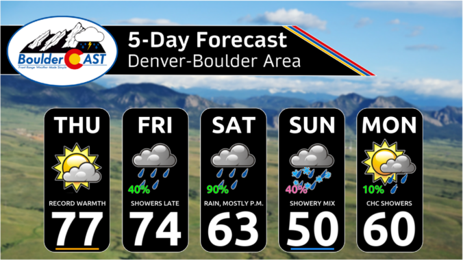
Following a chilly and unsettled first week of April, this week will be much quieter across Colorado with generally warm and dry conditions favored throughout the entire week under the protection of high pressure. Temperatures will fluctuate a tad due to a pair of dry backdoor cold fronts, but otherwise this week will offer-up gorgeous spring weather. That theme will continue right into the upcoming weekend with the first 80-degree temperatures of the year likely. Read on for all the details.
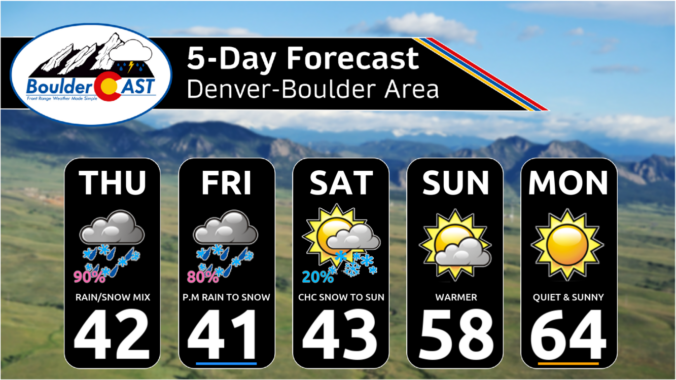
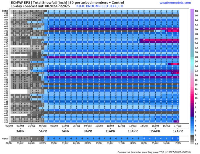
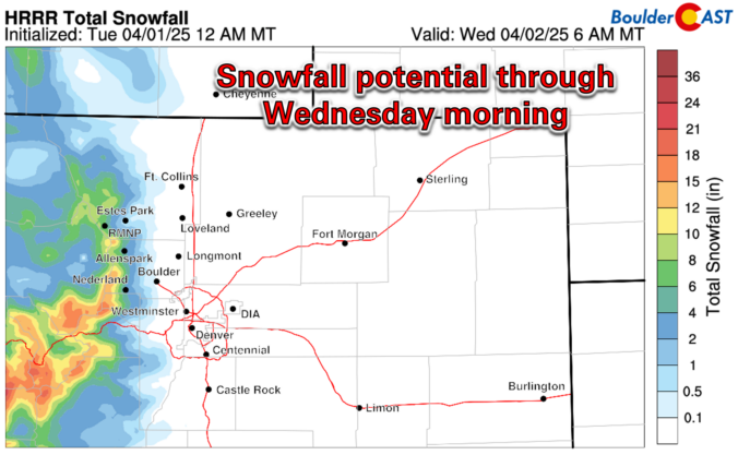
Today’s gloomy mix of rain/snow remains on-track for the Front Range, spreading into the area quickly this afternoon before ending around midnight. Most of the actual snow accumulation will occur in/near the Foothills, with minor travel impacts in the higher terrain where slushy roads will occur. Another similar round of mixed precipitation will unfold again Friday afternoon into Friday night, with light accumulations possible as well, especially after the sun goes down Friday evening. We discuss the latest forecast details, inbound snowfall potential and when warmer weather will return.
A big dip in the jet stream across the western United States will funnel two weak storm systems eastward in the coming days leading to a prolonged period of cool and gloomy weather to the Front Range that will take us right into the weekend. Our discussion here focuses mainly on the first storm set to move across Colorado on Thursday with a mixed bag of rain and snow. We’re expecting minimal travel impacts across the Boulder-Denver area due to warm temperatures, but some problems may occur in the higher terrain. Continue reading

Live View of Boulder

Current Conditions

Live Radar

Recent Premium Posts

BoulderCAST Daily – Sun 06/21/26 | First Notable Smoke Plume Arrives for the First Day of Summer
🌫️ Smoky skies return: A large wildfire in Utah has smoke surging into …
BoulderCAST Daily – Sat 06/20/26 | Supercells on the Plains, Fire Danger in the High Country & Boulder Quiet In Between
🌩️ Severe storms fire east of I‑25 this afternoon with supercells producing 1.5–2.5″ …
BoulderCAST Daily – Fri 06/19/26 | Quiet end to the week but storms return Saturday, including a significant severe risk towards Kansas
☀️ Quiet finish to the week — Weak ridge brings sunshine, light winds, …
3-Day Forecast

Trending Content

© 2026 Front Range Weather, LLC