Author: Ben Castellani (Page 3 of 294)
Ben grew up in southwestern Pennsylvania and holds both a bachelor's and a master's degree in Meteorology, the latter being from CU Boulder. His hometown received nearly three feet of snow from the Storm of the Century back in March of 1993, sparking his initial interest in impactful weather. Ben currently works on remote sensing and data analysis software at NV5 Geospatial Software in Boulder.

Snow has been falling steadily since midnight, turning the Front Range into a real winter wonderland on this Wednesday. We review the regional snowfall totals so far, and discuss the latest forecast details, including when we expect this snowstorm to loosen its grasp on the Front Range.
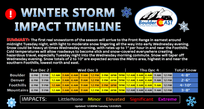
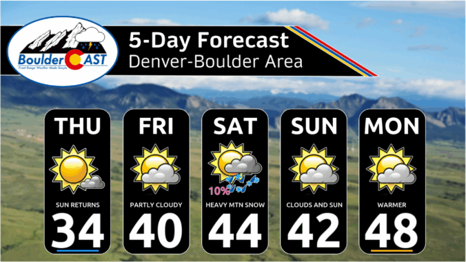
Snow season has finally arrived along the Front Range, and this week’s storm looks ready to deliver more than just a token dusting. After Thanksgiving’s overhyped flurries broke our snow drought, we’re now tracking a midweek system with real staying power—nearly 24 hours of upslope flow, solid moisture, and model agreement pointing to a medium‑impact event. Boulder, Denver, and the Foothills are all in line for several inches, with tricky travel expected Wednesday morning. Curious how much snow your neighborhood could see? We break down the setup, snow totals, and timing…
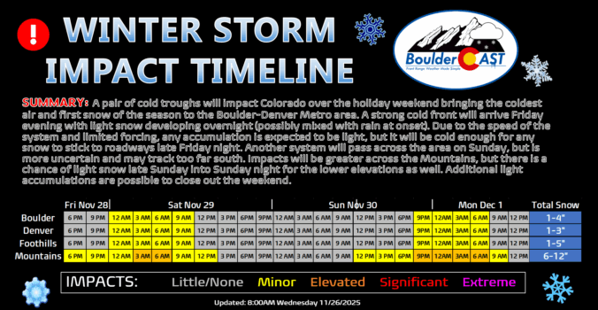
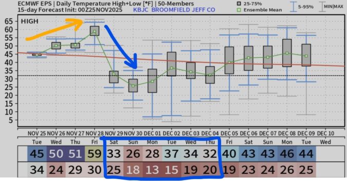
A big change is about to hit Front Range: after one more warm, breezy Friday, a strong cold front sweeps in overnight, dropping temperatures to the coldest of the season. Will Denver and Boulder finally see their first snow? That’s not guaranteed, unfortunately, but the Mountains are in for several fluffy inches and tricky travel ahead. Read on for the full breakdown—including details on the timing, our snowfall map, travel impacts and what lies ahead for our next wintry system on Sunday.
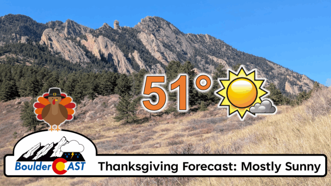
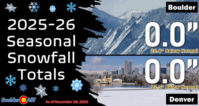
After weeks of unseasonable warmth, the Front Range is staring down its first taste of winter. Mild weather will continue for the next few days, including a beautiful Thanksgiving holiday, but by Friday night a powerful cold front will surge into Colorado, ending this historic snow drought with our first flakes of the season likely to fall. Read on for a full breakdown of what to expect and when, including our preliminary snowfall forecast map for Friday night.
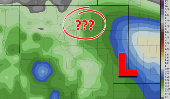
Enjoy Wednesday’s sunshine while it lasts—it’s the calm before a complicated storm setup arrives tomorrow. A pair of low‑pressure systems are set to interact in a complicated manner late Thursday into Friday, leaving big questions about how exactly things will unfold across eastern Colorado. Read on for our latest thoughts on the developing late-week autumn storm headed for the Front Range.

Live View of Boulder

Current Conditions

Live Radar

Recent Premium Posts

BoulderCAST Daily – Thu 01/08/26 | Snow develops today but still some uncertainty, amounts have been lowered
❄️ Snow develops today: Snow develops today, but uncertainty still lingers with two …
BoulderCAST Daily – Wed 01/07/26 | Quiet today but snowflakes are on the horizon tomorrow
⛅ Quiet Weather Today: Highs will be mild in the upper 50s in …
BoulderCAST Daily – Tue 01/06/26 | Critical Fire Conditions Today
🔥Critical Fire Conditions: Fire Weather conditions could be critical today with gusty winds …
3-Day Forecast

Trending Content

© 2026 Front Range Weather, LLC