


Author: Ben Castellani (Page 229 of 358)

Ben grew up in southwestern Pennsylvania and holds both a bachelor's and a master's degree in Meteorology, the latter being from CU Boulder. His hometown received nearly three feet of snow from the Storm of the Century back in March of 1993, sparking his initial interest in impactful weather. Ben currently works on remote sensing and data analysis software at NV5 Geospatial Software in Boulder.

DayCAST: Thu 01/24/19

Good morning all! Everything is coming together just a little late this morning, but the forecast looks in good shape. Moderate to heavy snow bands are starting to develop just north of the Metro area as the strongest upslope arrives. The current radar as of 6:45 AM is shown below. That band has snowfall rates of 1 to 1.5" per hour. …

DayCAST: Wed 01/23/19

Snow totals from Monday night into Tuesday Break in the action today, more winter weather tomorrow We're in for a rather tranquil morning today as we rest briefly in-between weather systems. A benign, dry, and cool northwest flow is in place over Colorado. This will lead to generally sunny skies this morning. Moisture ahead of the next quick-moving storm system will spread into …

DayCAST: Tue 01/22/19

Thus far, the storm has played out largely as expected. The cold front moved through around 9:00 PM Monday night, accompanied by gusty winds and a few heavy bands of snow. The subsequent development of light snow on the backside of the front has been minimal for much of the Metro area under northerly low-level winds. Totals will more than …

*Premium Storm Update* A quick check on the latest model runs

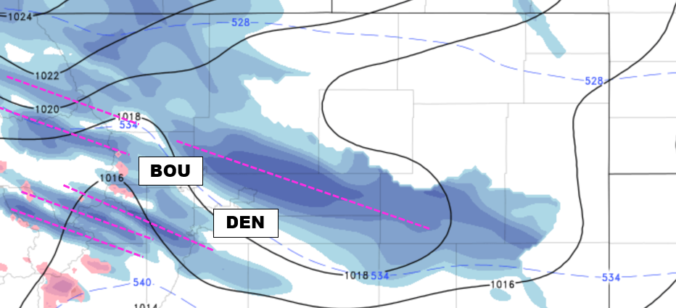
As we discussed in our forecast update earlier this morning, despite the storm system already bearing down on western Colorado with widespread snowfall, the European model continues to stand-alone in its prediction of the storm's speed and track over the next 12 to 24 hours. The graphic below shows 500 mb heights at 3:00 AM Tuesday morning. We have added in …

DayCAST: Thu 01/17/19

Ridge today, gone tomorrow A short-lived ridge is passing through today, with drier west-northwest flow present across Colorado (see below). This will help taper-off any lingering snow showers across the High Country well before sunrise this morning. The break in the action will be brief, though... You can also see the next storm headed our way tonight and tomorrow. As strong …

DayCAST: Wed 01/16/19

Mountain snow today, dry but overcast in Denver Widespread snowfall is underway across most of the Mountains of western Colorado this morning. The focus the first half of the day will be across southwest Colorado, with this favoritism shifting to northwest Colorado for the afternoon and evening hours. The reason for this shift is two-fold: There are actually TWO separate …

« Older posts Newer posts »
