Author: Ben Castellani (Page 173 of 358)

Ben grew up in southwestern Pennsylvania and holds both a bachelor's and a master's degree in Meteorology, the latter being from CU Boulder. His hometown received nearly three feet of snow from the Storm of the Century back in March of 1993, sparking his initial interest in impactful weather. Ben currently works on remote sensing and data analysis software at NV5 Geospatial Software in Boulder.
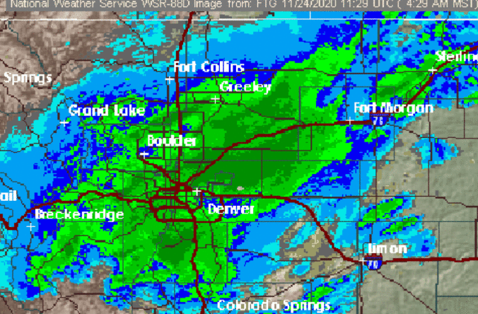
*Premium Storm Update* Tue 11/24/20 6:00AM

Heavy snow has developed right on schedule this morning after a brief period of rain overnight. Here's a look at the current radar animation as of 6:00 AM across the region. That's quite the band! There was substantial uncertainty regarding exactly where this heavier snow band would develop. The answer turned out to be a smidge further north along a …

BoulderCAST Daily – Thu 11/19/20 | Sunshine returns, Saturday snow chance has diminished

ADetailed Forecast Discussion: weak disturbance will shoot eastward across Wyoming and Montana through the day. This shortwave is shown below. Due to the track of the system, little consequence will befall Colorado with most of the energy well to our north. The jet stream will also reside just to our north for one more day allowing for another period of …

BoulderCAST Daily – Wed 11/18/20 | Much cloudier, but still unseasonably warm

UDetailed Forecast Discussion: nseasonably warm temperatures are expected again today with southwesterly downslope flow in full force. Yesterday's high temperature was 71°F in Boulder and we'll probably be similar today..somewhere in the realm of 70 degrees. The major change for today will be significantly increased cloud cover across the Front Range with moisture streaming in aloft. This morning's GOES-East infrared …

BoulderCAST Daily – Tue 11/17/20 | Getting warmer

WDetailed Forecast Discussion: arm and dry conditions will persist across the Front Range for at least a few more days. A shortwave ridge is moving through today which will facilitate calm winds and mostly sunny skies, along with mid-level flow backing to southwesterly. This southwest flow will help usher in even warmer temperatures compared to yesterday as a long lee …

BoulderCAST Daily – Thu 11/12/20 | Quiet & cool again

ADetailed Forecast Discussion: nother day, another frivolous assault of progressive shortwaves moving across the Rockies! There are three systems of interest today barely worth discussing. A departing system moving into the Great Lakes. The trailing trough from this low is just clipping northern Colorado with some large-scale lift and moisture continuing snowfall in the northern Mountains this morning. If you …

BoulderCAST Daily – Wed 11/11/20 | Dry and mostly sunny the next few days

IDetailed Forecast Discussion: t will be another active day of weather across the United States as the storm track continues to push along the northern tier of the country. Tropical Storm Eta remains on a path to make a landfall somewhere along the Gulf Coast this weekend. This tropical cyclone is very slow moving and the exact track has been …

« Older posts Newer posts »