


Author: Ben Castellani (Page 151 of 358)

Ben grew up in southwestern Pennsylvania and holds both a bachelor's and a master's degree in Meteorology, the latter being from CU Boulder. His hometown received nearly three feet of snow from the Storm of the Century back in March of 1993, sparking his initial interest in impactful weather. Ben currently works on remote sensing and data analysis software at NV5 Geospatial Software in Boulder.
This week in Colorado weather: July 26, 2021

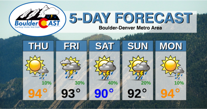
After a somewhat surprising urban flood scenario in Boulder on Sunday, smoky air and a heatwave will again be the forecast headlines this week for the Front Range as a strong ridge of high pressure develops just to our north and east. High temperatures will remain in the 90’s through Friday with just meager late-week rain chances. With a staggering number of large wildfires burning upstream, smoke will stay the course this week as well. Read on for our complete forecast of the week ahead.

Continue reading

BoulderCAST Daily – Thu 07/22/21 | Lessened storm chances today, but rain stays in the forecast through the weekend

SDetailed Forecast Discussion: lightly drier air has worked into northeast Colorado this morning as the monsoon plume slides just a bit further south and west. This can be seen in this morning's GOES-East water vapor animation. The deepest moisture is now across western and particularly southwestern portions of the state. This shift is related to the large-scale high pressure which …

BoulderCAST Daily – Wed 07/21/21 | An afternoon wave of showers & storms, watching the burn scars for flash flooding

ADetailed Forecast Discussion: subtle but important pulse of monsoon moisture will be passing through the region today offering up our best chance of rainfall for the week! The mid-level water vapor animation below shows that the plume of monsoon moisture, which has been well to the west the last several days, has finally worked into the Front Range. The eastward …

BoulderCAST Daily – Tue 07/20/21 | Warm & smoky today, storms return tomorrow

TDetailed Forecast Discussion: he axis of the ridge will tilt and rotate slightly eastward today before completely flattening out and weakening in the coming days. The center of the high is located in southwest Colorado with the flow of monsoon moisture beginning to return to the Western Slope. There will also be a slight uptick in moisture for the Denver …

BoulderCAST Daily – Fri 07/16/21 | Lower 90’s with isolated storms, plus the first major hurricane of 2021 has formed!

VDetailed Forecast Discussion: ery little change in the overall weather pattern is noted today compared to yesterday for the area. A weak trough stretches from Minnesota southward into northeast Colorado. This trough will act as a focal point for storm development later today. West of this trough axis in the Front Range, drier westerly flow and slight subsidence will inhibit …

BoulderCAST Daily – Thu 07/15/21 | More sun & less storms as drier air has taken over

RDetailed Forecast Discussion: ainfall totals yesterday were far from impressive in most areas due in large part to the stubborn cloud cover we mentioned in yesterday's discussion. Shown below are the observed precipitation amounts from Wednesday (radar estimated). Most everyone saw at least a few sprinkles, with upwards of 0.5" in the heavier cells. Overall the abundant cloud cover really …

BoulderCAST Daily – Wed 07/14/21 | Numerous afternoon showers and storms are expected, but uncertainty is elevated

YDetailed Forecast Discussion: ou know it's going to be an active monsoon day when notable precipitation is already falling at sunrise across portions of southwest Colorado, which is upstream from us in the current monsoonal flow pattern. As of 6:00AM, there's a large batch of mainly light to moderate rainfall occurring in the southwest corner of the state which is …

« Older posts Newer posts »
