Winter weather is knocking on the door again in Boulder and Denver beginning Sunday evening. Read our complete forecast covering the timing and amounts for a long-duration snowfall event that won’t fully wrap-up until late Tuesday night.
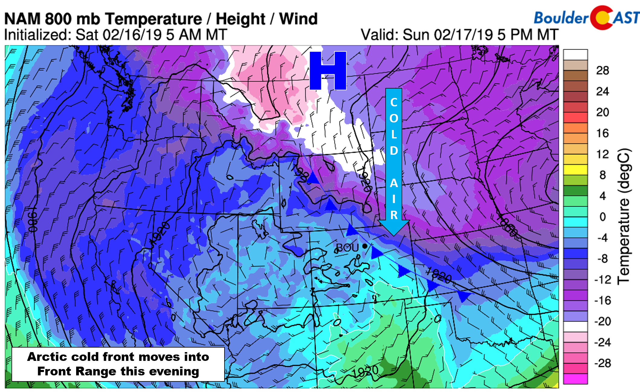
Quiet weather Sunday afternoon will transition downhill by evening as an Arctic cold front backs into the Front Range from the northeast. The southward push of the very cold air is fueled by falling heights from an approaching trough to our west and a strong 1045 mb Arctic high dropping south out of Canada.
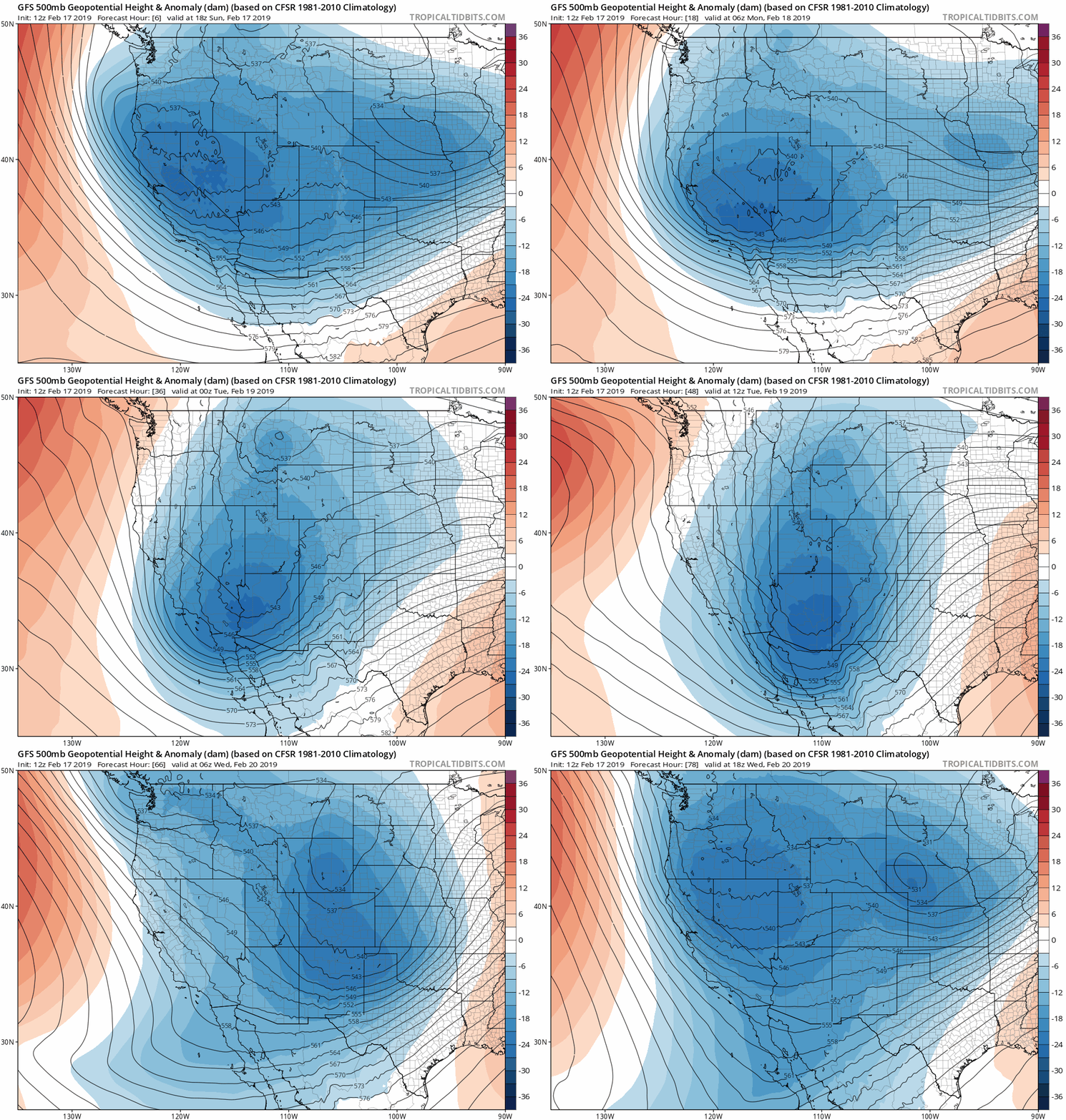
As you can see in the GFS 500 mb height anomaly animation below, there is rather broad and complex troughing present across the West. The animation spans 72 hours from Sunday morning through Wednesday morning. It’s clear that the trough isn’t going anywhere quickly. Unsettled and unseasonably cold weather will be with us for the next several days in Colorado as a result.
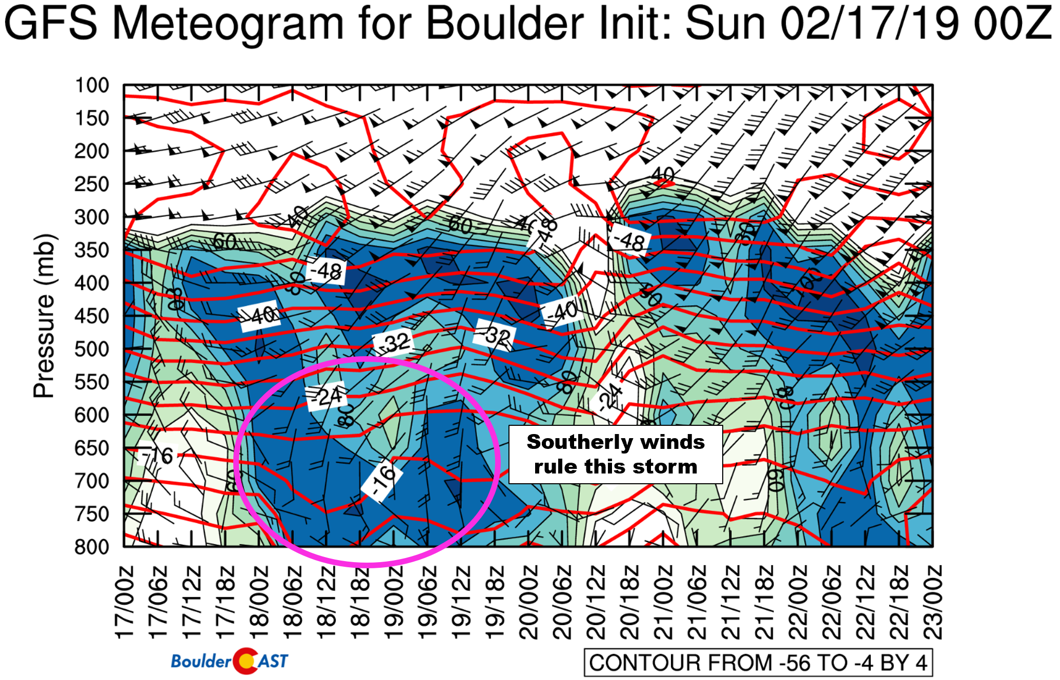
The first large-scale piece of energy with this trough will slowly migrate into the Four Corners region by Tuesday. This storm system will be slow to materialize overall. Yes the very cold air and upslope will be in place near ground-level for us…..but, higher up, winds will turn southerly and most of the energy from the trough will pass through southern Colorado. The more impressive snow totals will be across southern portions of our state as a result. We finally get a slow-moving storm…and of course the track and dynamics are unfortunately not ideal for the Front Range! We do stress that this is going to be a LONG-DURATION and INTERMITTENT snow event. The airmass is very cold so we should see excellent (i.e. high!) snow to liquid ratios and minimal melting throughout. Both of these facets will help accumulate snow slowly across the Front Range.
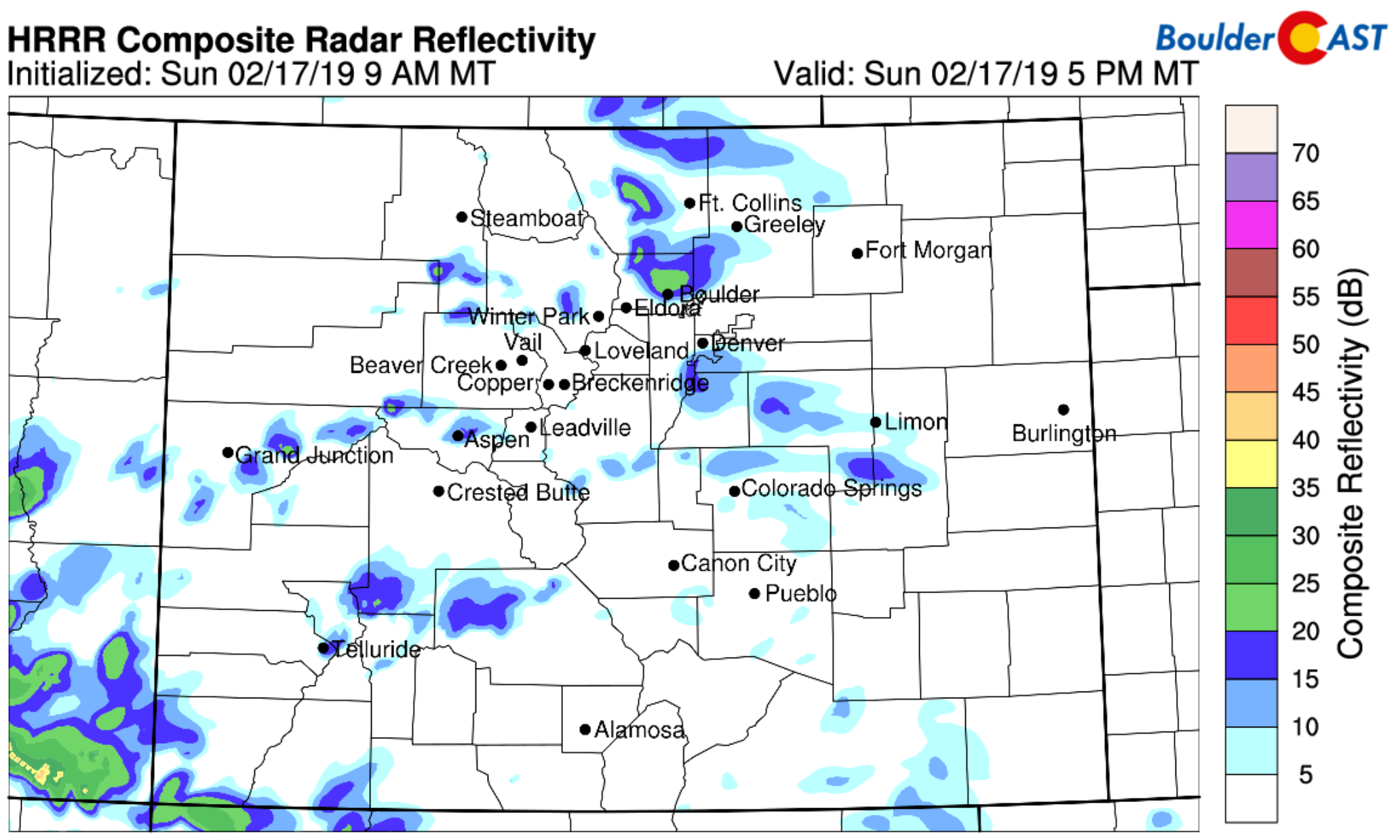
We expect snow to begin in our region around sunset Sunday evening as the initial wave of NORTHEASTERLY upslope arrives to the Metro area. As of 2PM Sunday afternoon, the front is situated right along the Wyoming border. High-resolution models are indicating that a few moderate bursts of snow will be possible as the front arrives and combines with pre-frontal instability. The focus for this heavier snow chance will be in and near the Foothills (see the HRRR simulated radar for 5PM below).
This first period of snow will continue for the region through the nighttime hours into Monday morning. Most models then show low-level winds turning SOUTHEASTERLY near ground-level and SOUTHERLY at 700 mb.
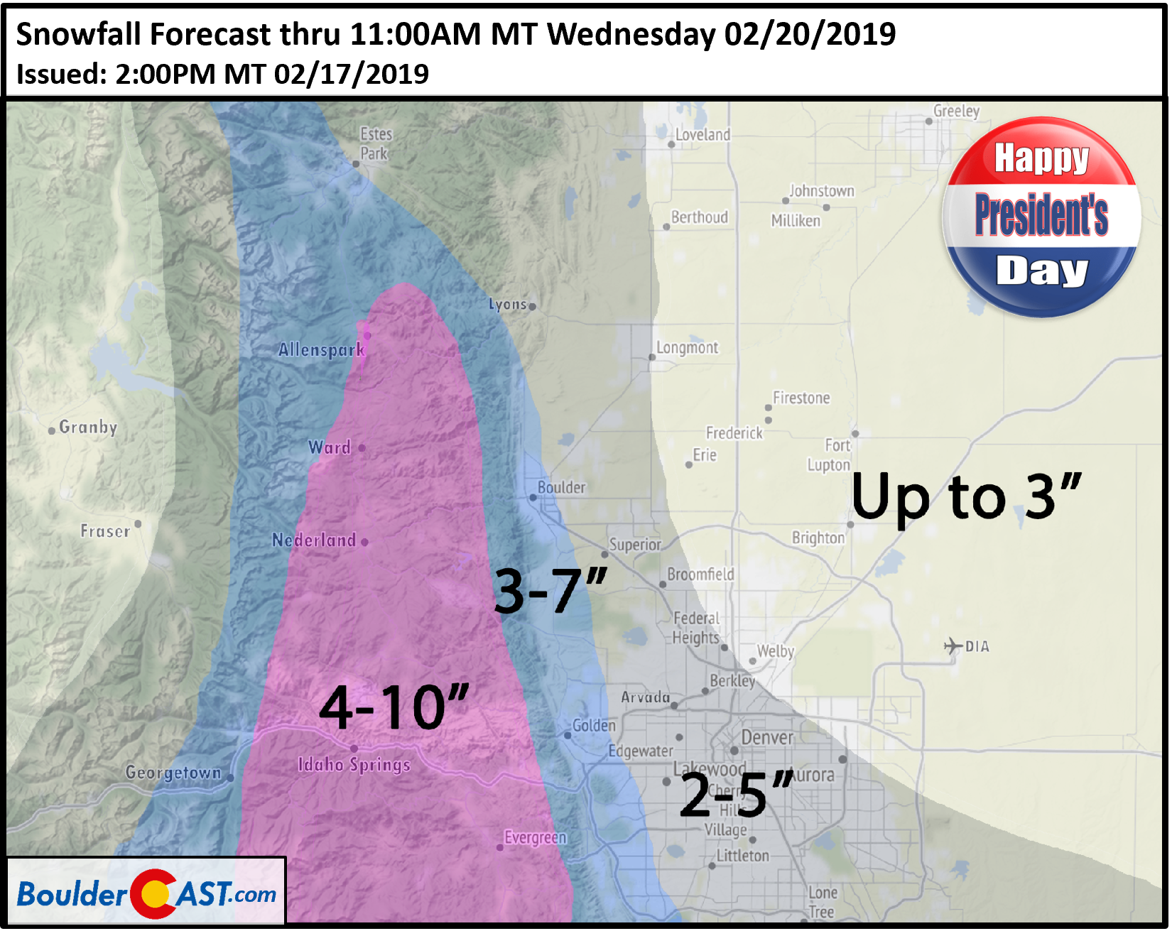
This directional shift downslopes the Denver Metro area from the Palmer Divide to our south and we do expect snow to let up during the day Monday as a result. Still, models are showing some decent snow totals for the first wave of the storm in our region, bolstered undoubtedly by those high snow ratios and few moderate snow bands at the storm’s onset Sunday evening. Come Monday morning, most lower elevation areas should have anywhere from 1 to 3″ on the ground. In the Foothills, it will be more like 2 to 5″.
We likely won’t see winds turn back to northeasterly again for the rest of the storm. However, as the main energy from the trough inches closer to Colorado Monday night, we’ll start to see an uptick in large-scale lift. This should be enough to spread light snow across the entire region again Monday night through Tuesday night. We could very well see snow totals double as a result of this secondary wave.
We will add that this storm system doesn’t have much moisture at all to work with. It’s an Arctic airmass….dry air of course comes with the territory. Nonetheless, the long duration of the event will help to squeeze what little moisture there is out across Colorado. Finally, as the storm exits and winds turn northwesterly, snow chances wane late Tuesday night with snow fully-gone most likely before sunrise Wednesday.
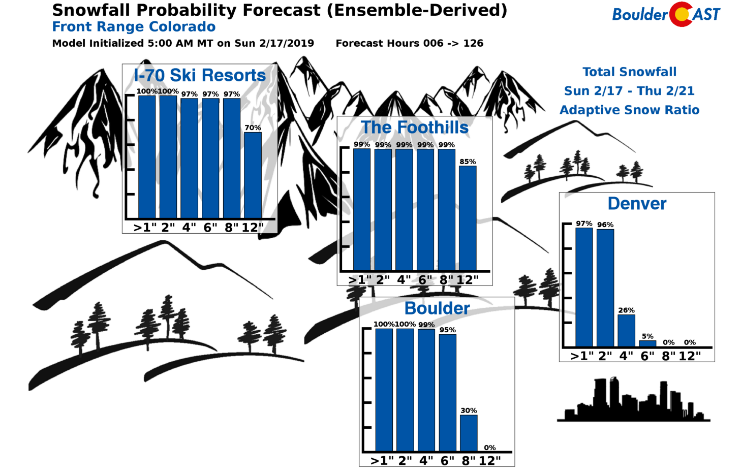
A check in on our snowfall probability charts shows pretty good odds of higher-end totals in Boulder and the Foothills, with much lower chances in Denver.
NOTE: We do caution that these charts cover the next 120 hours (5 days), and as such, they are also capturing a little bit of snow from our next potential storm on Thursday. More on that late-week storm in another post…
Here are the take-aways:
- This is a LONG duration event with intermittent light snow being the primary concern. From the first flakes to the last ones, we’re talking close to 60 hours from Sunday evening into late Tuesday night.
- Snow won’t be falling continuously for everyone at all times. While there will be plenty of hours of snow, there will also be plenty of snow-less hours as well.
- At the onset of the snow Sunday early evening, a few embedded moderate snow showers will be possible. Otherwise, we’re talking light snow into Tuesday night.
- Wind fields in and around the Denver Metro area will be key to where the highest totals will be, especially considering the tricky southeasterly flow and possible swirling expected Monday night into Tuesday. Our confidence is lower regarding the secondary wave of snow during this time.
- It’s going to be VERY COLD. We’re talking lows in the single digits and highs in the teens Monday, 20’s Tuesday and maybe back to near freezing by Wednesday. Beyond this, we probably won’t get back to normal temperatures anytime soon, which by the way is in the mid to upper 40’s this time of year.
- Travel could be a little slick Sunday night through Tuesday night. Though we expect road crews can handle this low intensity event just fine. We may see Winter Weather Advisories get posted by the National Weather Service, if nothing more than for awareness.
Our snowfall forecast map for the lengthy event is shown below. Keep in mind about half of this will occur Sunday evening into Monday morning, and the other half Monday night into Tuesday night.
Have a safe and happy President’s Day holiday!
Go ahead…share our forecast:
.






You must be logged in to post a comment.