With record-challenging heat to start and a dramatic cooldown looming midweek, Colorado’s weather is shifting gears—and fast. A powerful ridge is driving us toward 100° on Monday, but it won’t stick around. By midweek, cooler temperatures and increased rain chances roll in, possibly delivering relief via much-needed moisture. We break down the evolving setup, the timing of the incoming cold front, and what it could mean for rainfall totals, flash flooding risk, and your week ahead.
This week’s highlights include:
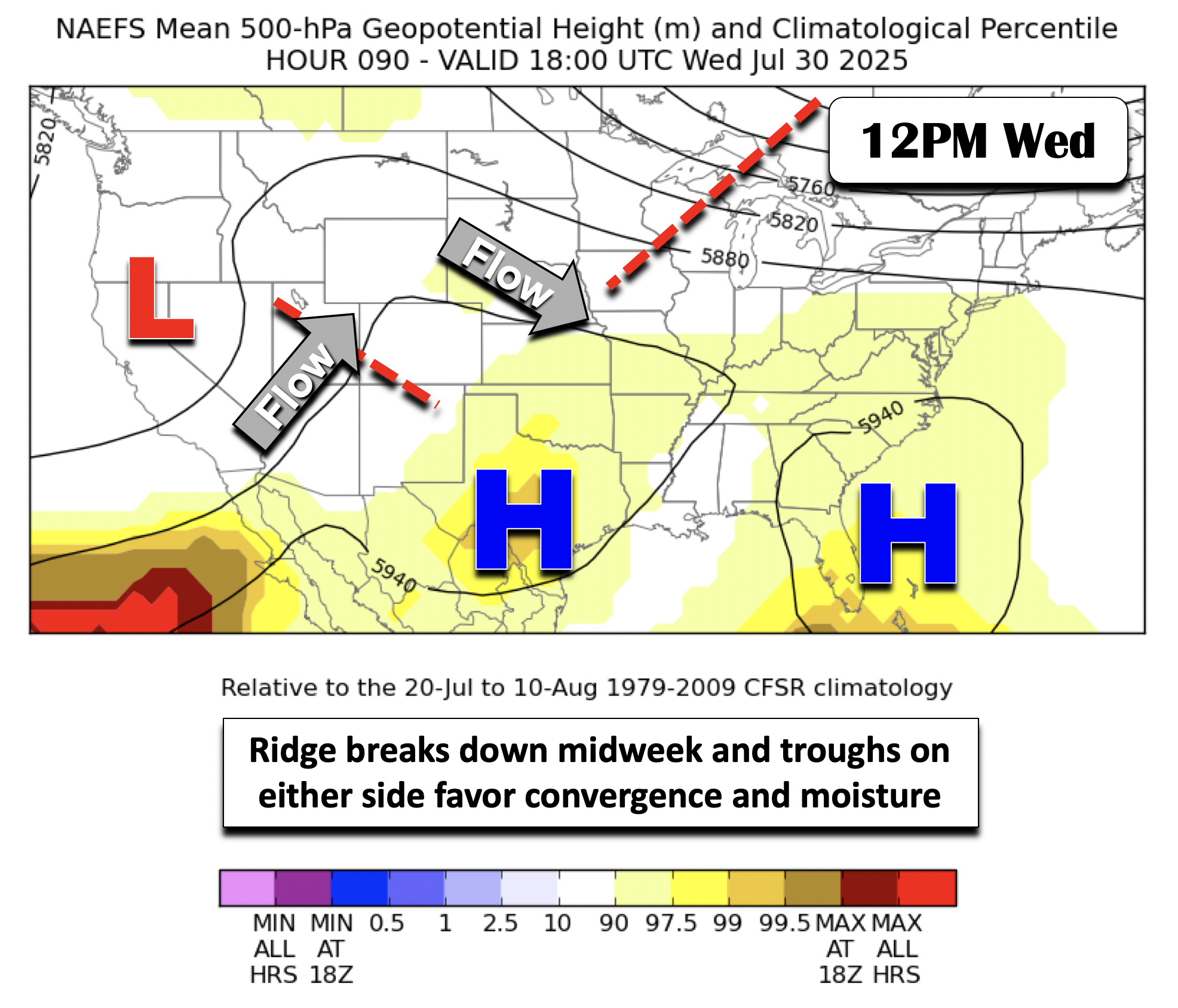
- Extreme heat kicks off Monday, driven by a highly anomalous ridge over much of the U.S.—500mb heights exceed the 99th percentile for this time of year.
- Cooler temps arrive midweek, as the ridge breaks down and troughs on either side of Colorado help usher in a surface cold front.
- Rain chances climb Tuesday through Thursday, with enhanced moisture and upslope flow combining to support scattered storms and locally heavy rainfall.
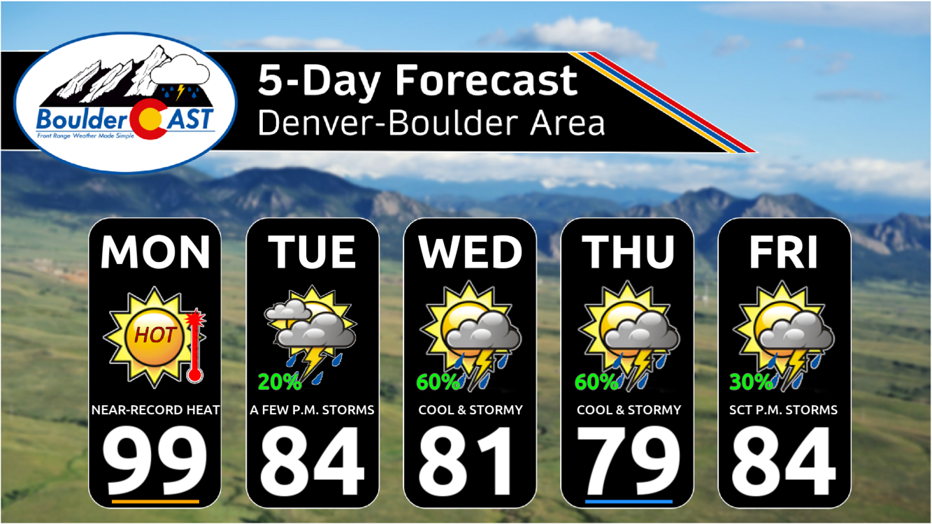
- Highs drop from near-record levels Monday (~100°) to upper 70s–80s, especially by Wednesday and Thursday
- Flash flooding risk increases, especially on Wednesday, when the NOAA’s WPC places some of our area at a Slight Risk for excessive rainfall.
- Total rainfall may range from 0.75″ to 1.5″ across Colorado, with locally higher amounts possible—though variability is expected.
DISCLAIMER: This weekly outlook forecast is created Monday morning and covers the entire upcoming week. Accuracy will decrease as the week progresses as this post is NOT updated. To receive daily updated forecasts from our team, among many other perks, subscribe to BoulderCAST Premium.

Go Premium, get all the perks.
Daily Forecast Updates
Get our daily forecast discussion every morning delivered to your inbox.
All Our Model Data
Access to all our Colorado-centric high-resolution weather model graphics. Seriously — every one!
Ski & Hiking Forecasts
6-day forecasts for all the Colorado ski resorts, plus more than 120 hiking trails, including every 14er.
Smoke Forecasts
Wildfire smoke concentration predictions up to 72 hours into the future.
Exclusive Content
Weekend outlooks every Thursday, bonus storm updates, historical data and much more!
No Advertisements
Enjoy ad-free viewing on the entire site.
Record highs possible Monday, but it gets better the rest of the week
It will be a HOT start to our week on Monday, followed by a cool-down with increased rain chances for the middle to latter part of the week. A series of weather features will allow this shift to take shape, which we will discuss next. But first, our week starts off with a highly anomalous ridge of high pressure covering much of the U.S. This feature is centered over the northern Gulf but reaches into the Midwest, Plains, and East Coast. How extreme is it? 500mb heights are in the climatological 99th percentile for late July, which is rare territory, according to CFSR reanalysis:

The week will boil down to a few key features, partly to do with the ridge just mentioned and some surface high and upper-trough changes:
- The highly anomalous ridge will weaken come midweek, allowing near-record highs in eastern Colorado to be short-lived
- At the same time, troughing flanking on either side of Colorado will force a surface cold front to move south midweek, aided by a strong surface high building in the Great Lakes Thu/Fri
Together, this synoptic weather pattern change will cause the Front Range to go from extreme heat on Monday to well below normal temperatures by midweek and excessive rainfall chances as moisture filters in and surface/upper-level forcing increases. We’ll discuss this and more in the details that follow.
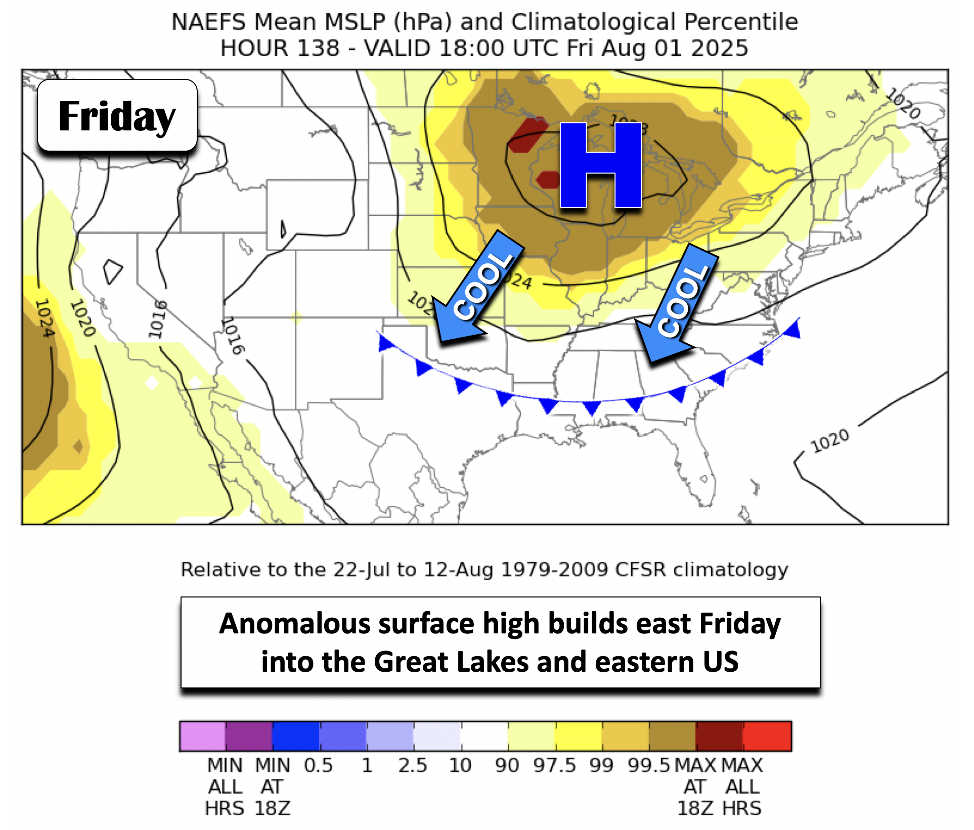
We mentioned the ridge weakening by midweek, and this is evident in the NAEFS ensemble below. By Wednesday, the highly anomalous shading weakens, with the ridge in two pieces, one over the western Atlantic, and another over southern Texas. Near-record highs Monday in the upper 90s to near 100° (our record in Boulder is 100 set in 1947) will drop considerably into the low to middle 80s the rest of the week. In fact, as we’ll discuss later, we may see just 70s in some spots come Wednesday or Thursday. As the ridge dissipates Wednesday and shifts south, two weak troughs, one over California and another over the Great Lakes, will allow a cold front to move in Wednesday. Moisture will also increase at this time for storms to surge back into the forecast.
Now let’s look at the surface, but for the latter part of the week. The surface cold front appears as though it will move through either late Tuesday or in the morning hours on Wednesday. Some guidance would suggest perhaps a pre-frontal trough moves in Tuesday. This is less certain but as a result of not great agreement in the models, highs Tuesday could vary from middle 80s to as high as low 90s, but the lower end of that range is the trend. Either way, the front will be well south of the Front Range late in the week, approaching the southern Plains of the U.S. and Mid-Atlantic. Much of the ensembles show an anomalous surface high near 1025mb building out of Canada Thursday (shown below). This will favor our cooler highs Wednesday and Thursday. Typically we should be in the upper 80s for the last week of July and first part of August.
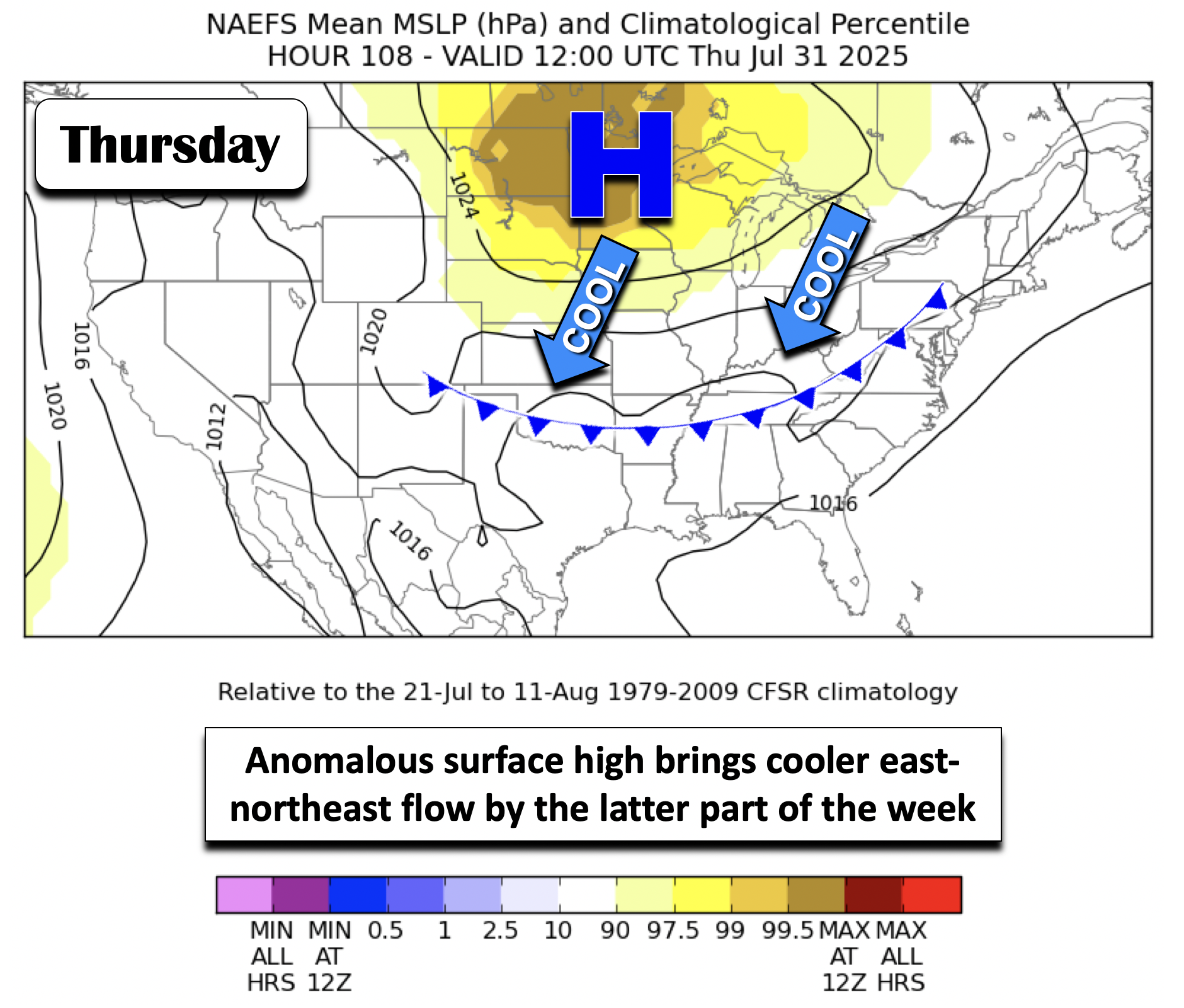
The surface high strengthens by Friday over the Great Lakes to almost 1028mb, though our flow may be more south-southeast instead of east-northeast at this time. So we should see highs closer to average to close out the week.
The combination of the weakening ridge aloft, troughs flanking Colorado (one east; one west), and moisture more or less increased to above average levels, should favor the uptick in storm chances from Tuesday into Thursday. Surface and mid-level convergence looks to maximize over the area Wednesday and parts of Thursday along the frontal zone.

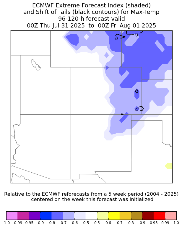
With the increased rain chances in this time frame and the easterly upslope flow and higher cloud cover, it’s no surprise the ECMWF extreme forecast index highlights potential anomalously low maximum temperatures on Thursday. Could highs not get out of the 70s on this day? It’s certainly a possibility but we’re not that at confident at this stage.
An easier perspective is from the NOAA Weather Prediction Center (WPC), which shows the frontal positions by Thursday. Notice how the higher rain chances collocate with the frontal zone, as we discussed above.
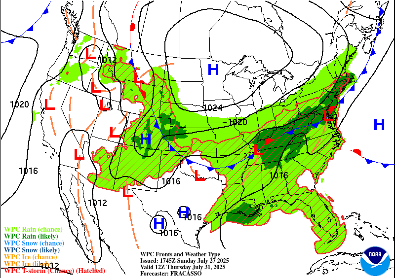
Notably, this frontal interaction and higher moisture content will increase our chances for heavy rainfall and possibly localized flash flooding. The WPC has placed a Slight Risk (Level 2 of 4) on Wednesday for excessive rainfall, though the risk is highest east of Denver into the Midwest.

That threat continues Thursday, although confidence is lower this far out. As it stands now, Wednesday looks like our best shot at meaningful rain.

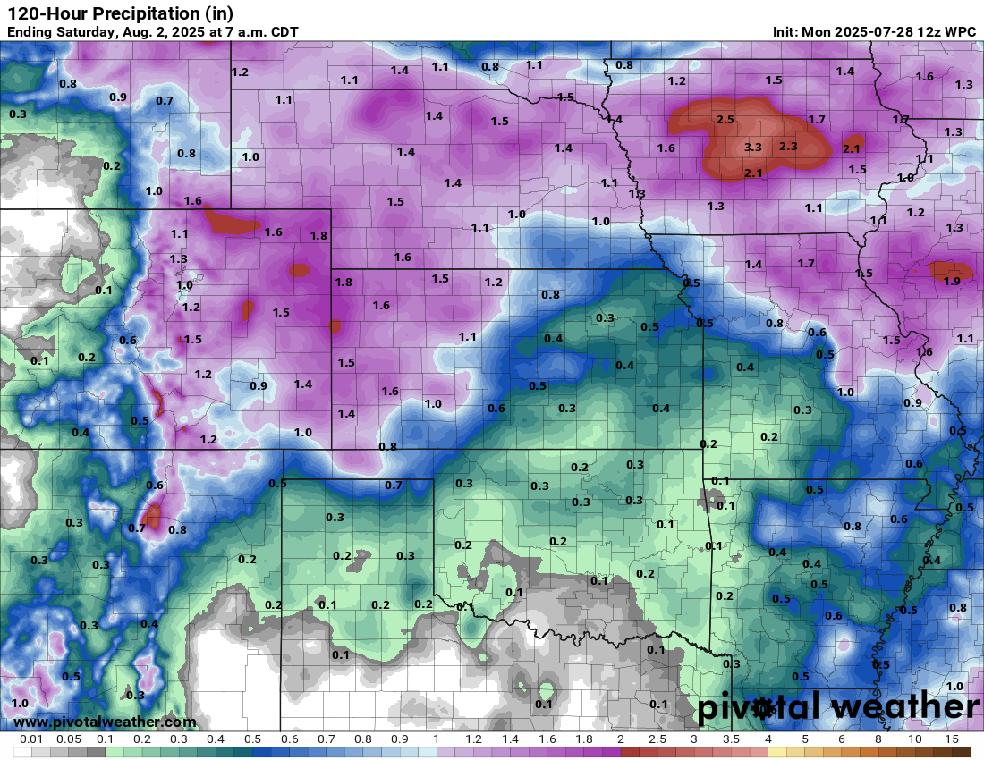
However, as we saw last week, there can be a huge variability in terms of rainfall amounts across the Front Range. Some of us saw very little, while other areas south and east saw higher totals up to 2 inches. Consider the below image, from the WPC, a worst-case scenario of rainfall through Friday evening. Over Colorado, it has a total rainfall ranging from 0.75 to 1.5″, with locally higher totals of 2+” in eastern Colorado.
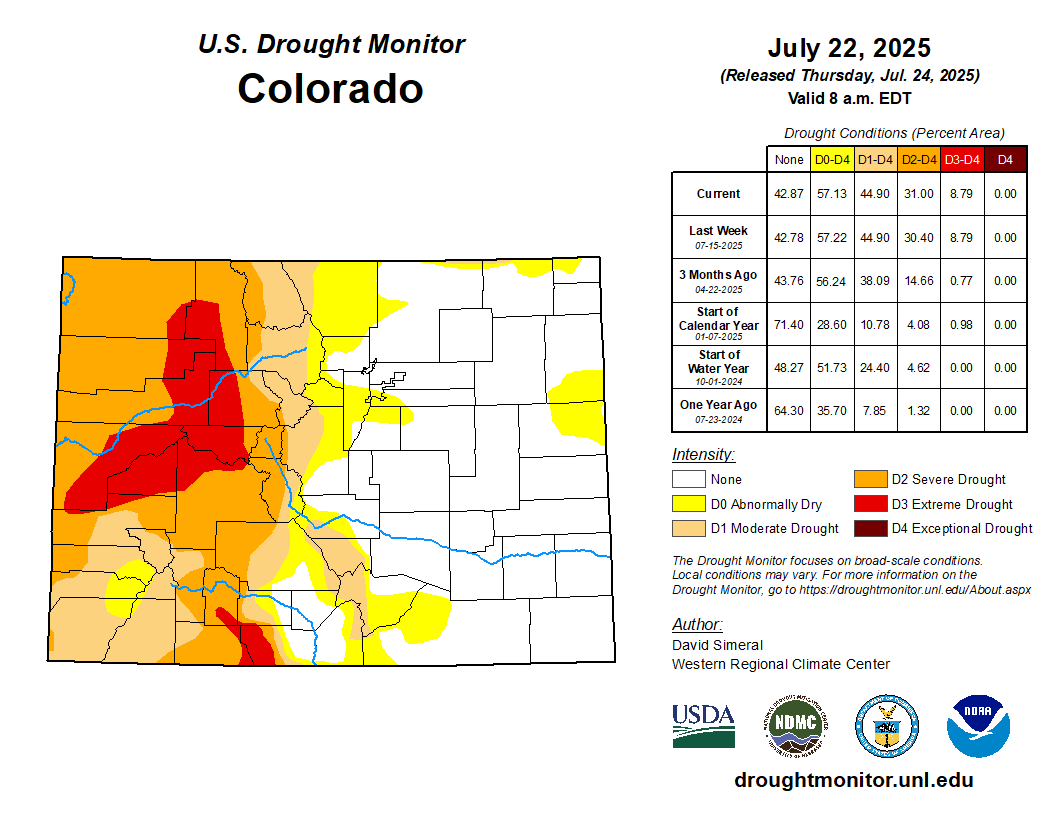
Unfortunately the rainy pattern this week will stay largely east of the Continental Divide, with drought-stricken western Colorado likely to miss out even in the wettest of scenarios.
We’ll keep an eye on things through the week and will provide any updates on the unsettled weather if needed.
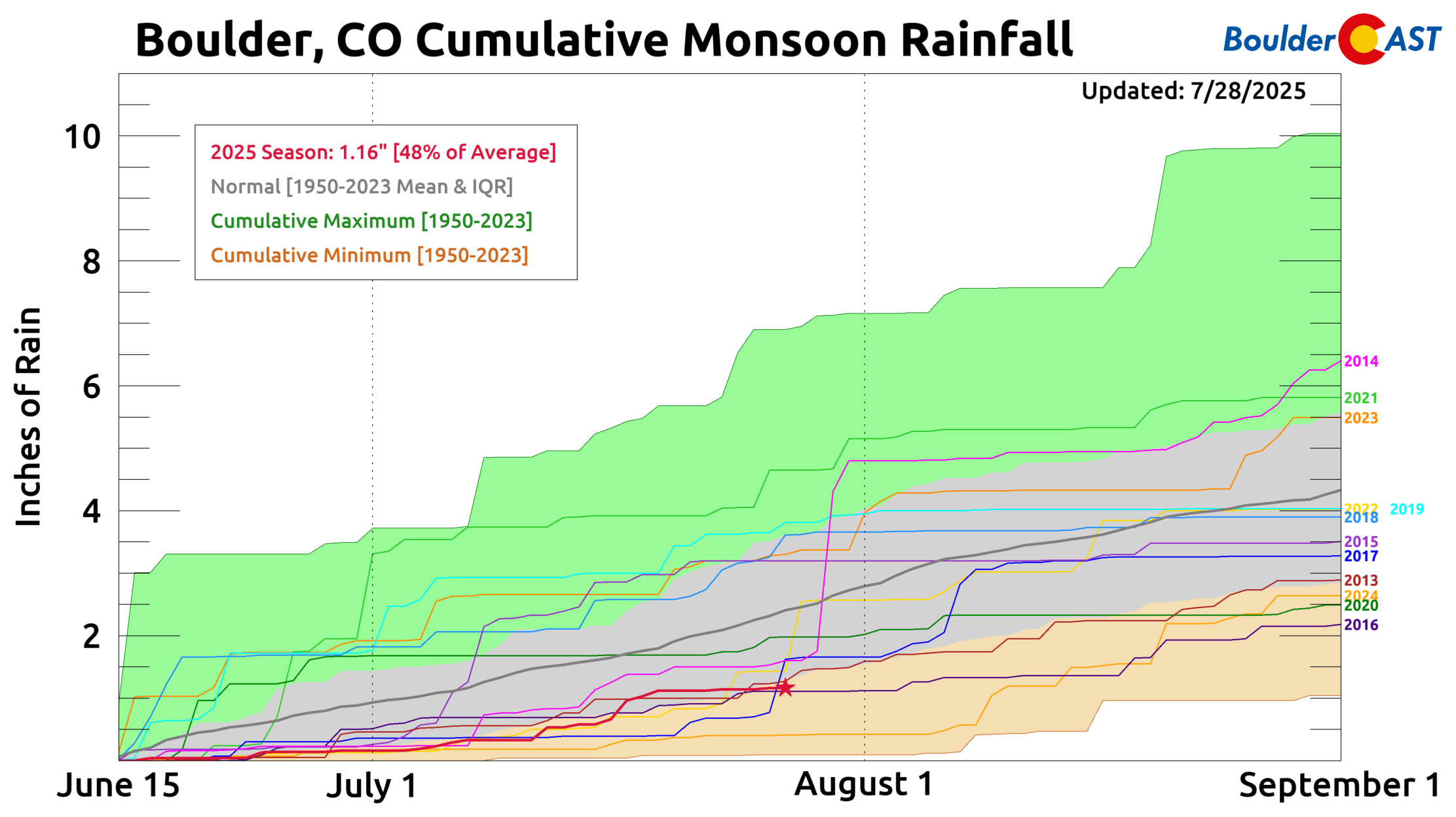
We could really use some rain at this point, even east of the Divide. Boulder has received just over an inch of rain in the last six weeks and we’ve recently fallen into the lowest quartile of monsoon climatology through July 27th. Fingers crossed that Mother Nature actually delivers the rain this week!
Forecast Specifics:
Monday: Near-record heat and mainly dry — just a scant chance of a gusty storm later on. Clouds increase considerably through the day which may ultimately save us from record readings. Highs in the upper 90s to near 100 on the Plains and upper 80s in the Foothills.
Tuesday: Not as hot but warm with low to middle 80s (though highs could vary from low 80s to near 90) on the Plains and near 80 in the Foothills. A chance of late-day isolated to widely scattered storms.
Wednesday and Thursday: Partly to mostly cloudy with scattered to numerous showers and storms favored. Storms could bring heavy rainfall. Highs in the lower 80s, though upper 70s may occur for portions of the area Thursday. Highs in the Foothills in the low 70s.
Friday: Trending more seasonal with a chance of isolated to scattered afternoon/evening storms. Highs in the middle 80s on the Plains and middle 70s in the Foothills.
Weekend: Ensembles suggest a drier westerly flow slowly takes hold, favoring highs getting closer to the upper 80s to lower 90s and only isolated afternoon and evening storms (i.e. typical late July weather).
DISCLAIMER: This weekly outlook forecast is created Monday morning and covers the entire upcoming week. Accuracy will decrease as the week progresses as this post is NOT updated. To receive daily updated forecasts from our team, among many other perks, subscribe to BoulderCAST Premium.
Go Premium, get all the perks.
Daily Forecast Updates
Get our daily forecast discussion every morning delivered to your inbox.
All Our Model Data
Access to all our Colorado-centric high-resolution weather model graphics. Seriously — every one!
Ski & Hiking Forecasts
6-day forecasts for all the Colorado ski resorts, plus more than 120 hiking trails, including every 14er.
Smoke Forecasts
Wildfire smoke concentration predictions up to 72 hours into the future.
Exclusive Content
Weekend outlooks every Thursday, bonus storm updates, historical data and much more!
No Advertisements
Enjoy ad-free viewing on the entire site.
Enjoy our content? Give it a share!


You must be logged in to post a comment.