
Get ready for soaking rain across the lower elevations, with heavy wet snow in the higher terrain of the Front Range. A powerful spring storm will impact Colorado this week, allowing for a lengthy period of deep upslope infused with Gulf of Mexico moisture. The bulk of the storm’s energy will hit from Monday afternoon through early Wednesday, bringing a dramatic shift in weather conditions to the area. Thick clouds and precipitation will keep temperatures feeling brisk, but by the end of the week, high pressure will return, ushering in a more seasonal warmth. Just how much rain are we expecting this week? How deep will the snow pile up in the Foothills and Mountains? And how far down could the snow levels plunge at the storm’s peak? Read on as we break it all down in this week’s outlook.
This week’s highlights include:
- Soggy Weather This Week: A slow-moving spring storm will bring wet weather to the area during the early to middle part of the week. The most widespread and intense precipitation is expected Tuesday morning into Tuesday night.
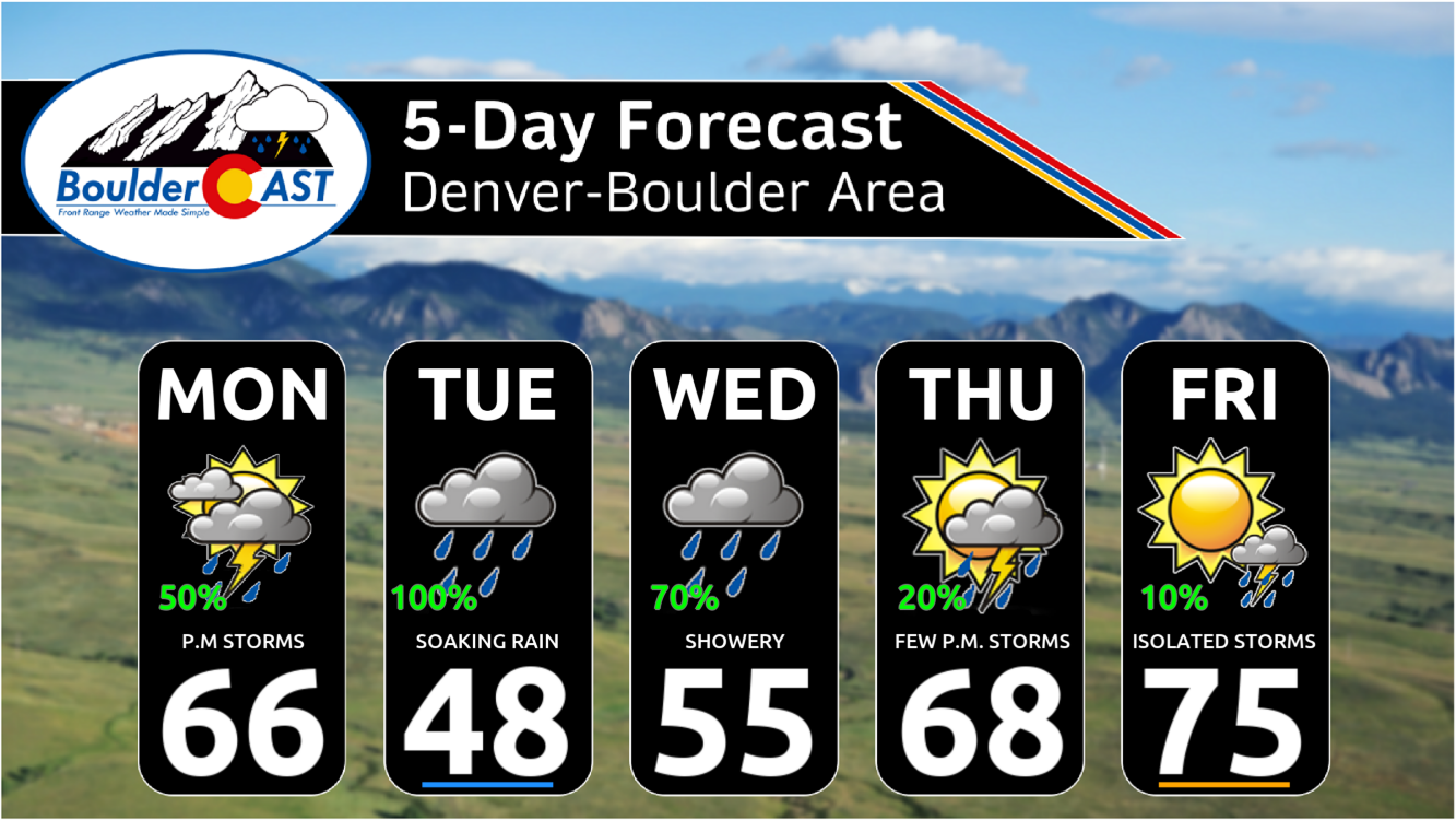
- Temperatures: Temperatures start out chilly with all the clouds and rain around, but trend more seasonal by week’s end into the 70s.
- Rainfall amounts: Expected rainfall amounts between 1 and 2 inches by Wednesday
- Heavy snow higher up: Snow levels will drop to around 7000 feet Tuesday night, allowing for wet springtime accumulations in the Foothills. The highest elevation communities could see upwards of a foot of heavy wet snow.
- Drier & Warmer By Week’s End: Drier weather will take over for the latter part of the week and sticks around into the upcoming weekend
DISCLAIMER: This weekly outlook forecast is created Monday morning and covers the entire upcoming week. Accuracy will decrease as the week progresses as this post is NOT updated. To receive daily updated forecasts from our team, among many other perks, subscribe to BoulderCAST Premium.

Go Premium, get all the perks.
Daily Forecast Updates
Get our daily forecast discussion every morning delivered to your inbox.
All Our Model Data
Access to all our Colorado-centric high-resolution weather model graphics. Seriously — every one!
Ski & Hiking Forecasts
6-day forecasts for all the Colorado ski resorts, plus more than 120 hiking trails, including every 14er.
Smoke Forecasts
Wildfire smoke concentration predictions up to 72 hours into the future.
Exclusive Content
Weekend outlooks every Thursday, bonus storm updates, historical data and much more!
No Advertisements
Enjoy ad-free viewing on the entire site.
Unsettled through midweek: Wettest on Tuesday, and there will be snow
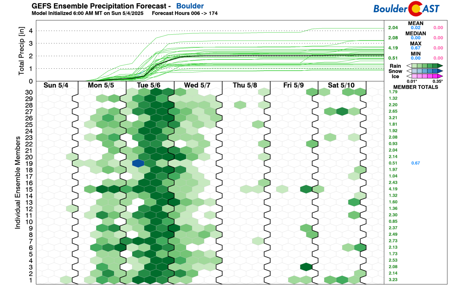
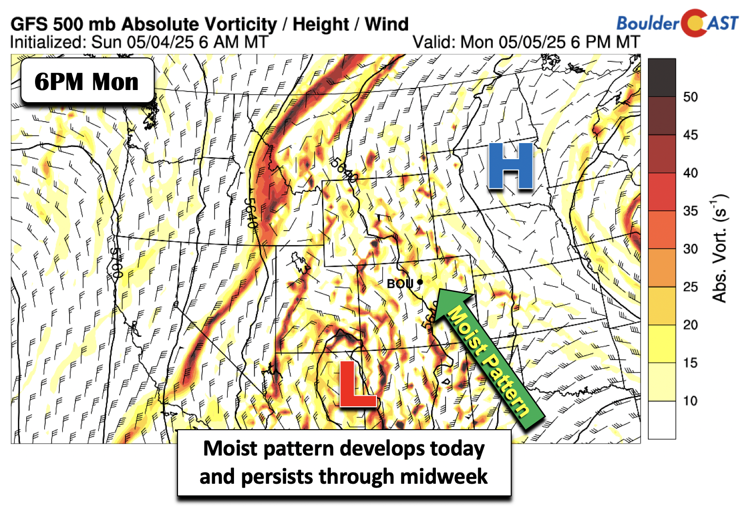
We have been discussing this incoming spring storm for the better part of seven days now, first mentioned in our Monday outlook post from one week ago. Thus, the looming wet weather should come as no surprise to anyone as it unfolds Monday and continues through midweek. While it won’t be a continuous 72 hours of rain, there will be more wet weather than dry weather to say the least. Below shows the GEFS precipitation plume for the week. It depicts the ramp up of rainfall later on Monday but especially Tuesday afternoon and night, when our heaviest period rainfall is expected. We’ll discuss the soggy weather, and where snowflakes will occur from this event as colder air gets pulled into the storm Tuesday night.
A slow-moving closed-low pressure system will be responsible for this wet weather, bringing a prolonged period of upslope precipitation to the Front Range. As of Monday morning, the big low pressure is nearly stationary across south-central Arizona. This can be seen in the GOES-East water vapor animation:
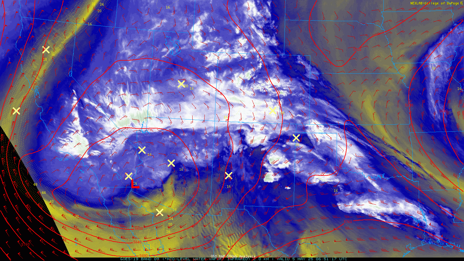
By Monday evening, the system will be just south of the Four Corners. Gulf of Mexico moisture will be spreading north as the day wears on, with scattered showers and isolated storms starting around midday and continuing off and on through late Monday night. Not everyone will see rainfall on Monday, but in general we expect a few showers or storms in most locations by the time things temporarily settle down Monday night.
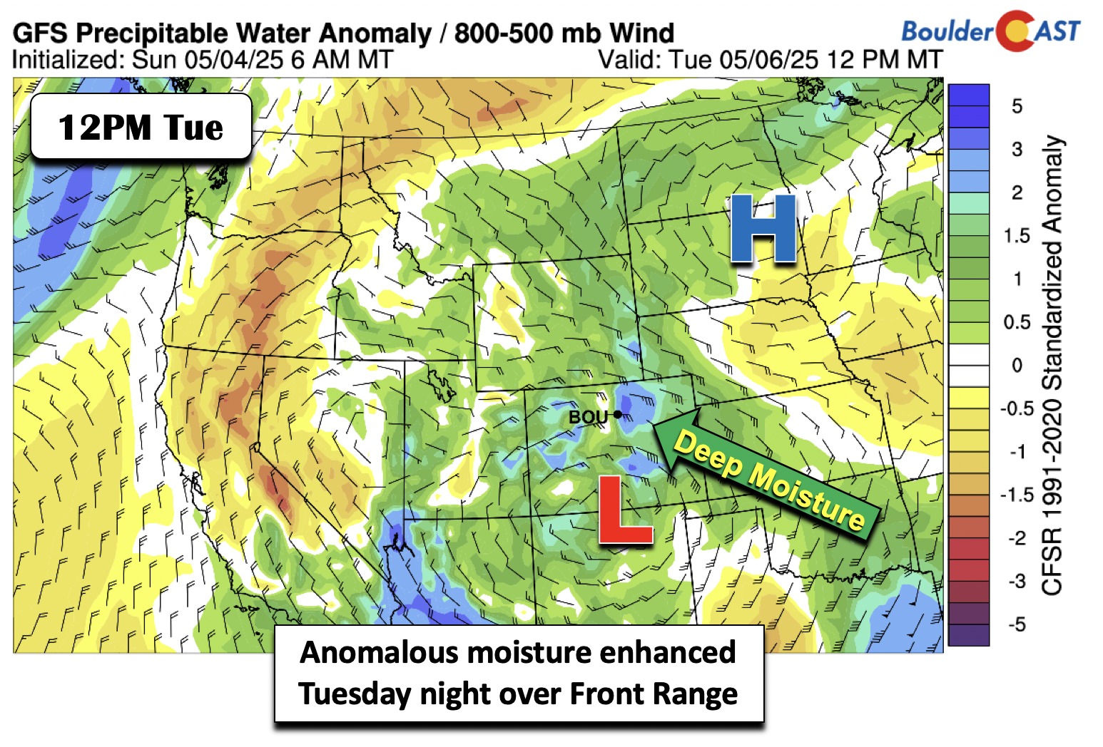
A period of dry weather is expected Monday night as lift partially wanes before a more widespread swath of precipitation develops Tuesday mid to late morning and continues into early Wednesday. This second wave will be our heaviest period of rain and where a majority of our accumulation will be realized. That heaviest period appears centered on Tuesday afternoon through Tuesday night. The system will be just west of the Texas Panhandle over northeastern New Mexico by Tuesday evening (see below), the absolute “chef’s kiss” for squeezing out moisture in our area. This position will favor a deep and moist upslope regime across the Denver Metro and adjacent Foothills. It will also be our coldest day of the week, with only upper 40s to lower 50s expected for daytime highs — about 25 degrees below normal for early May.
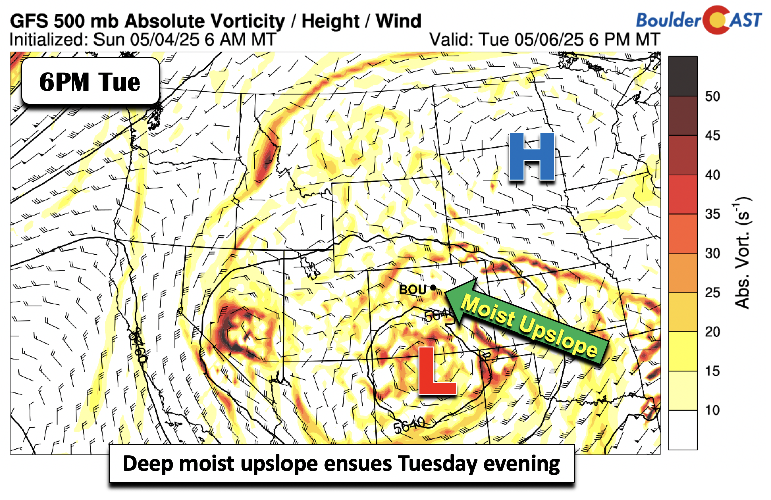
Anomalous Gulf moisture will be in place Tuesday evening, with a stiff easterly wind at low-levels near 35 MPH (!) — an impressive upslope regime that will support moderate to, at times, heavy precipitation in the Front range.
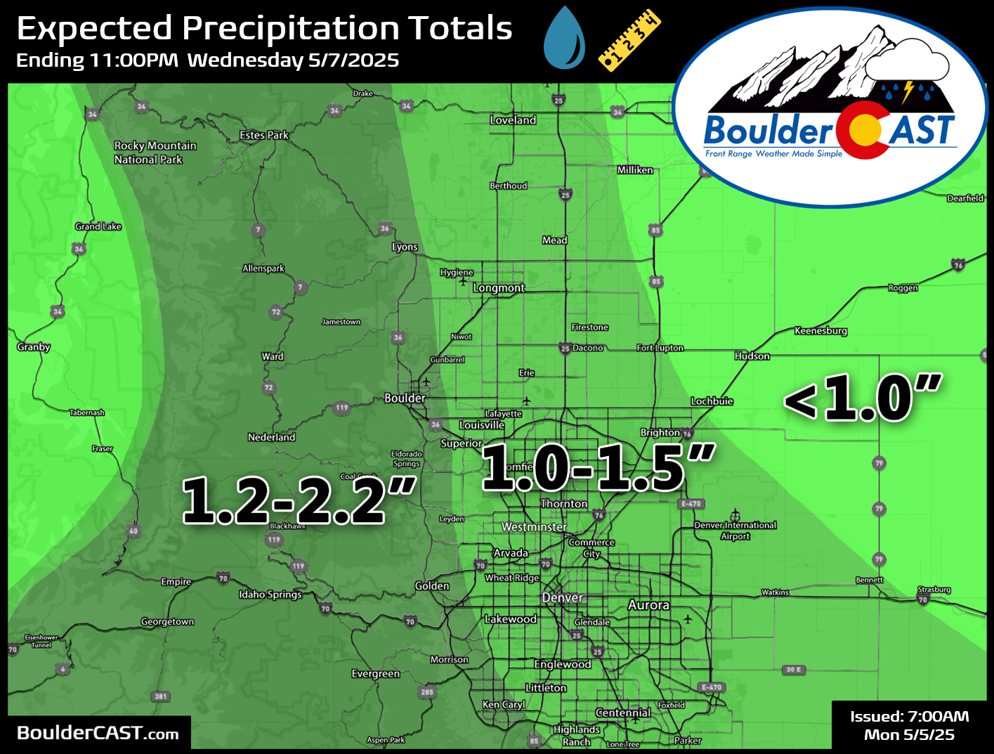
The expected precipitation totals through Wednesday morning have not changed much over the past day or three — we’re staring down a solid 1 to 1.5 inches or rain, with up to 2 inches possible in in the western suburbs (Boulder included) and the Foothills due to enhancement from the terrain.
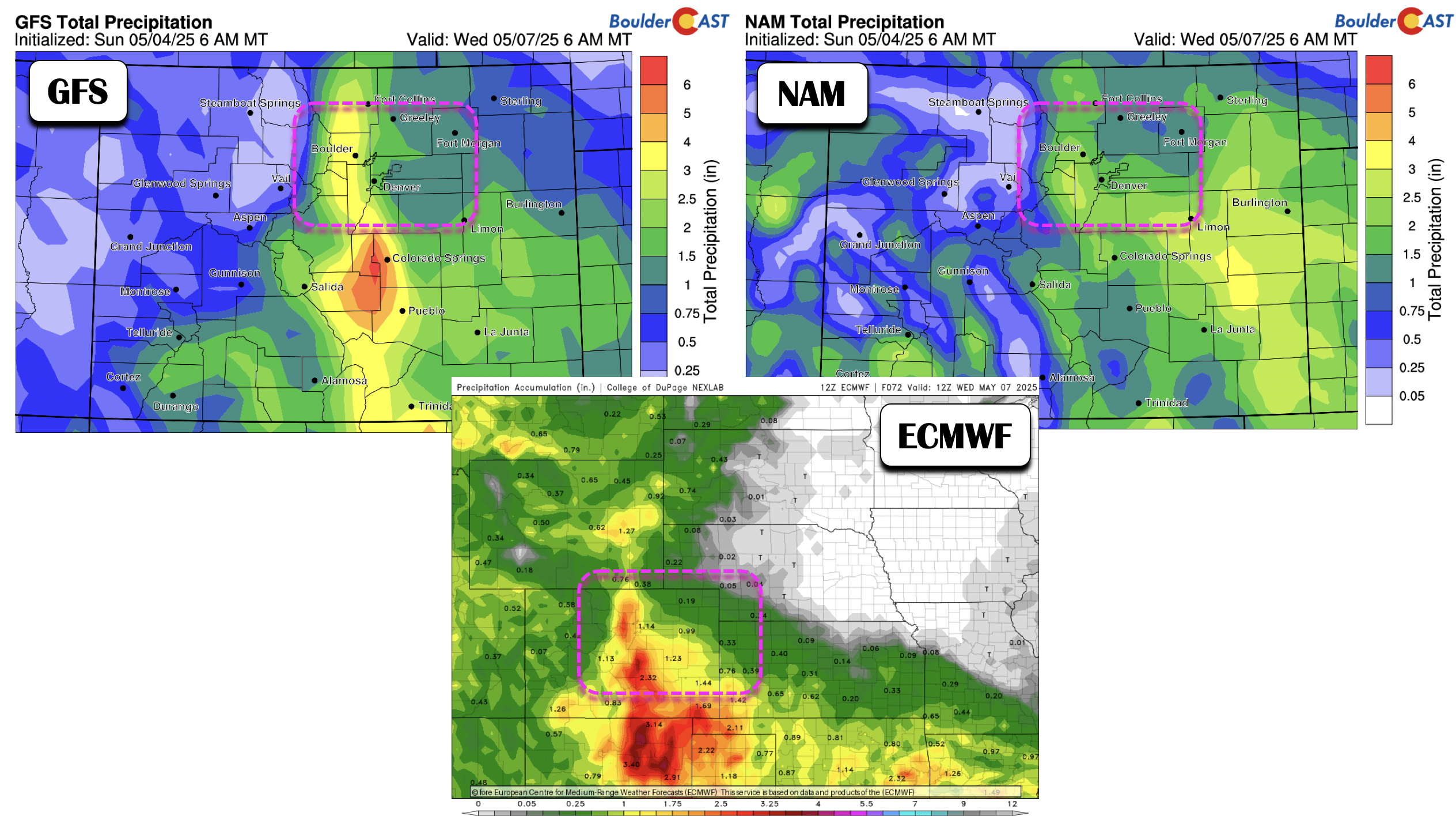
Our official precipitation forecast for this event is shown below, covering all precipitation through Wednesday evening. Again, most of the Denver Metro area will see 1 to 1.5 inches of rain, while Boulder could see upwards of 2 inches of rain. To put this into perspective, this is about 10% of our annual precipitation occurring over just about 48 hours!
Something we did not believe possible until recently was whether it could get cold enough for a few snowflakes to mix in across the lower elevations. While that risk still appears minimal at best, there are some colder model solutions, including the one from the NAM model below, which suggest the low-level airmass at 5000 feet up will be near -2 to -3°C Tuesday evening and night. The GFS shows temperatures at this level slightly warmer near freezing, so it certainly bears a mention.
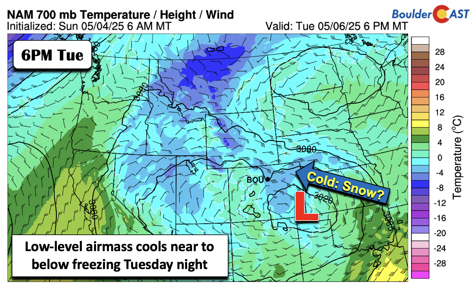
The best chance for any snowflakes mixing in would be Tuesday night, after the loss of solar heating (since we are now in May), and when the NAM suggests snow levels may dip below 6000 feet. The GFS, as expected, is closer to 6500 feet for Tuesday night.
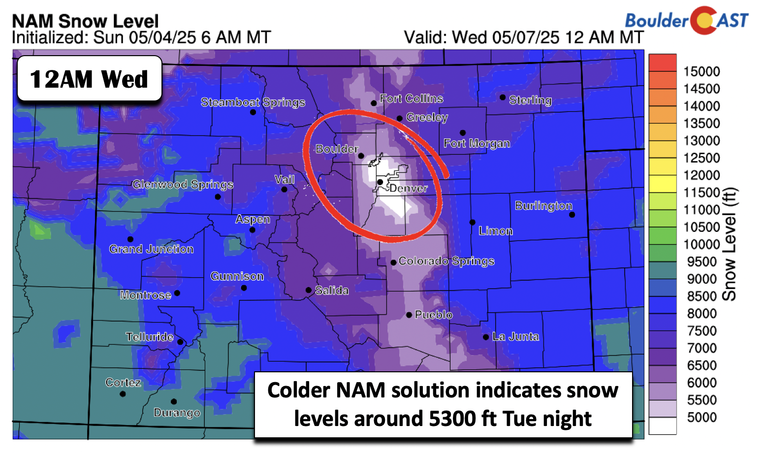
Certainly snow levels will be low enough for flakes to be the predominant precipitation type over the higher Foothills — anyone above 8000 feet should be prepping for a significant late-spring snowstorm right now. The NAM model suggests a foot or more along the high eastern slopes of the Front Range Mountains.
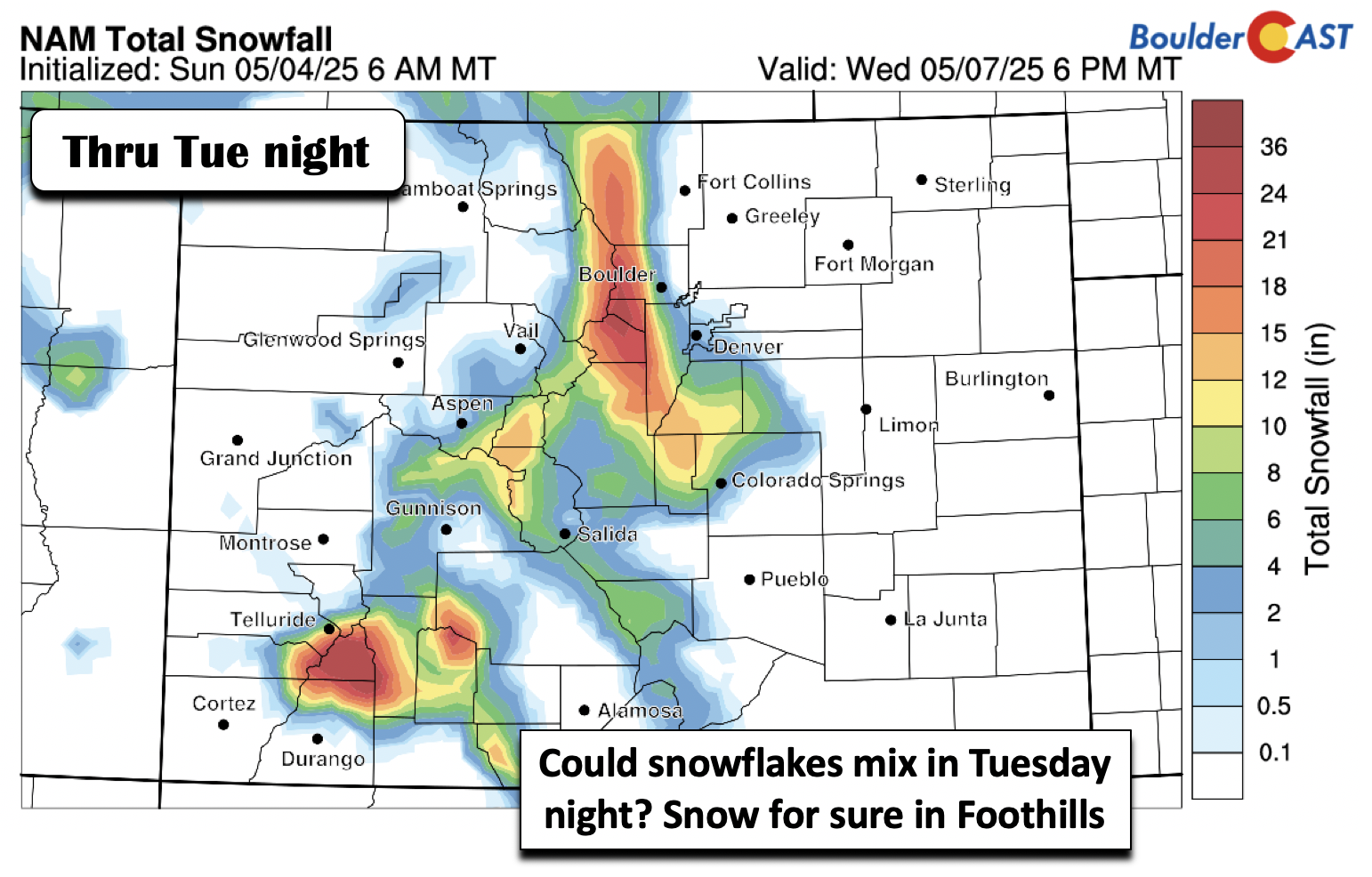
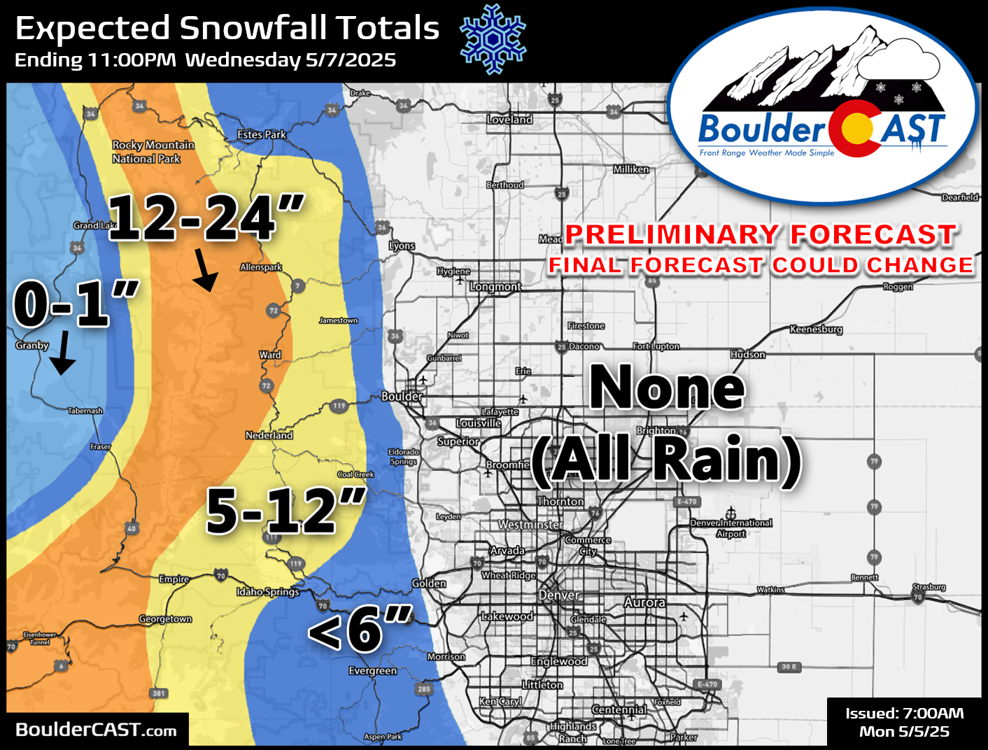
Our preliminary snowfall forecast map for this week’s event is shown below, covering all snow through Wednesday evening. Most of this accumulation will occur Tuesday through Tuesday night. The Mountains and highest Foothills above 8500 feet elevation can expect one to two feet of snow with difficult travel developing Tuesday evening into Wednesday morning. Areas between 7500 and 8500 feet are looking at anywhere from 5 to 12 inches. The lower Foothills between 6500 and 7500 feet may or may not see much accumulation from this event, depending on exactly how cold it gets Tuesday evening/night. For now, we are predicting less than 6 inches for these locations, but it could end up being too warm to see any snow here. Models have been trending slowly colder of late, but as discussed earlier, we’re not exactly sure how far down snow levels will drop Tuesday night. The lower elevations of Denver and Boulder are expected to see all rain from this event — but a chilly rain at that!
Drying out and more seasonal for week’s end
Unsettled weather with the second wave of rain will largely come to an end Wednesday morning. However, we’ll still be in a cloudy and showery pattern with the low pressure just to our east over western Kansas or far eastern Colorado.
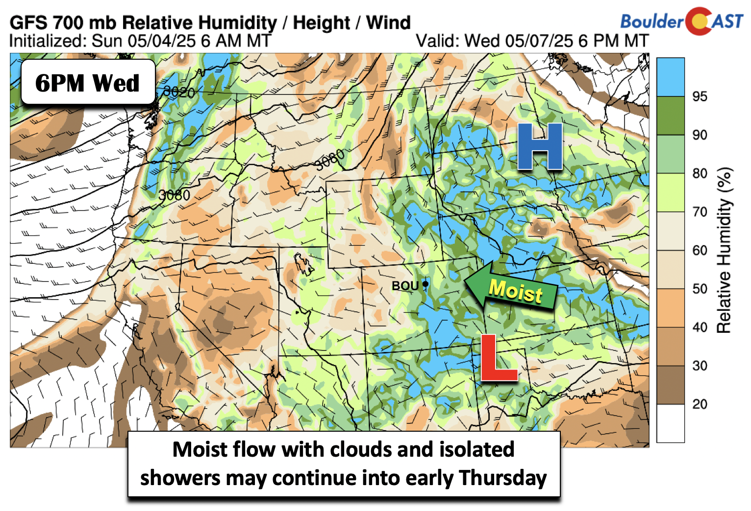
There are some model solutions that are slow to move the system out, and this may verify due to an omega blocking pattern to the east of the closed low. To that end, while it won’t be as widespread as Tuesday, diurnally enhanced isolated/scattered showers will be still favored Wednesday and partially on Thursday as well.
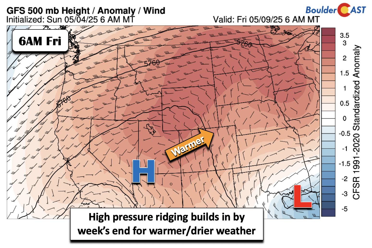
We should see drier weather by Friday as large-scale ridging is expected to build in when the pesky spring low pressure finally departs. This should also bring more seasonal temperatures with highs surging back into the 70s to end the week, a far cry from the 40s of Tuesday. Outside of a few stray daytime showers across the higher terrain, dry weather should be the norm for the upcoming weekend as well with temperatures in the middle 70s to near 80 degrees.
Enjoy the wet weather this week — it’s not often we get blessed with this many days of rain in a row here in semi-arid Colorado!
Forecast Specifics:
Monday: Morning sunshine becoming mostly cloudy with scattered showers and isolated storms develop through the afternoon and evening. Winds gusting 15 to 30 MPH from the southeast. Showers will be around off and on through evening, tapering off around midnight. Highs in the mid 60s on the Plains and mid 50s in the Foothills.
Tuesday: Some drizzle possible in the early morning, then widespread rain and a few embedded storms developing by late-morning, continuing through much of the day and overnight. Breezy winds from the east at times of 10 to 20 MPH. Highs in the upper 40s on the Plains, falling into the lower 40s in the evening. Highs in the low 40s in the Foothills, falling into the 30s and upper 20s overnight. Heavy snow will pile up in the higher Foothills about 7500 feet Tuesday evening and night, with upwards of a foot possible in the highest communities above 8000 feet.
Wednesday: Morning light rain, then cloudy with isolated to scattered afternoon and early evening showers. Highs in the mid to upper 50s on the Plains and mid 40s in the Foothills.
Thursday: Partly to mostly cloudy with isolated to scattered showers and storms possible. More dry time favored overall with highs in the 60s for the Plains and 50s for the Foothills.
Friday: Mostly sunny and warmer with highs in the low 70s on the Plains and low 60s in the Foothills. There’s a slight chance of a late-day thunderstorm, mainly across the higher terrain.
Weekend: Temperatures will trend above normal into the mid to upper 70s with just low-end isolated storms, mainly over the higher terrain.
DISCLAIMER: This weekly outlook forecast is created Monday morning and covers the entire upcoming week. Accuracy will decrease as the week progresses as this post is NOT updated. To receive daily updated forecasts from our team, among many other perks, subscribe to BoulderCAST Premium.
Go Premium, get all the perks.
Daily Forecast Updates
Get our daily forecast discussion every morning delivered to your inbox.
All Our Model Data
Access to all our Colorado-centric high-resolution weather model graphics. Seriously — every one!
Ski & Hiking Forecasts
6-day forecasts for all the Colorado ski resorts, plus more than 120 hiking trails, including every 14er.
Smoke Forecasts
Wildfire smoke concentration predictions up to 72 hours into the future.
Exclusive Content
Weekend outlooks every Thursday, bonus storm updates, historical data and much more!
No Advertisements
Enjoy ad-free viewing on the entire site.
Enjoy our content? Give it a share!


Any concerns about flooding in Boulder/foothills with this event?
No flooding concerns with this event. Slow and steady rainfall rates for the most part, but long duration. If we were to get over 3.5″ in 36 hours, maybe some slight concerns, but that won’t happen.