
While this week’s weather in the Front Range won’t be as flashy as last week’s snowstorm, there is still plenty to discuss! A gradual pattern shift through the week will see warm and dry conditions get replaced with cooler and wetter weather in time. There will also be some fire danger and severe storms this week across eastern Colorado. Read on for all the details.
This week’s highlights include:
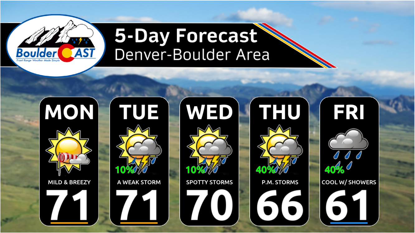
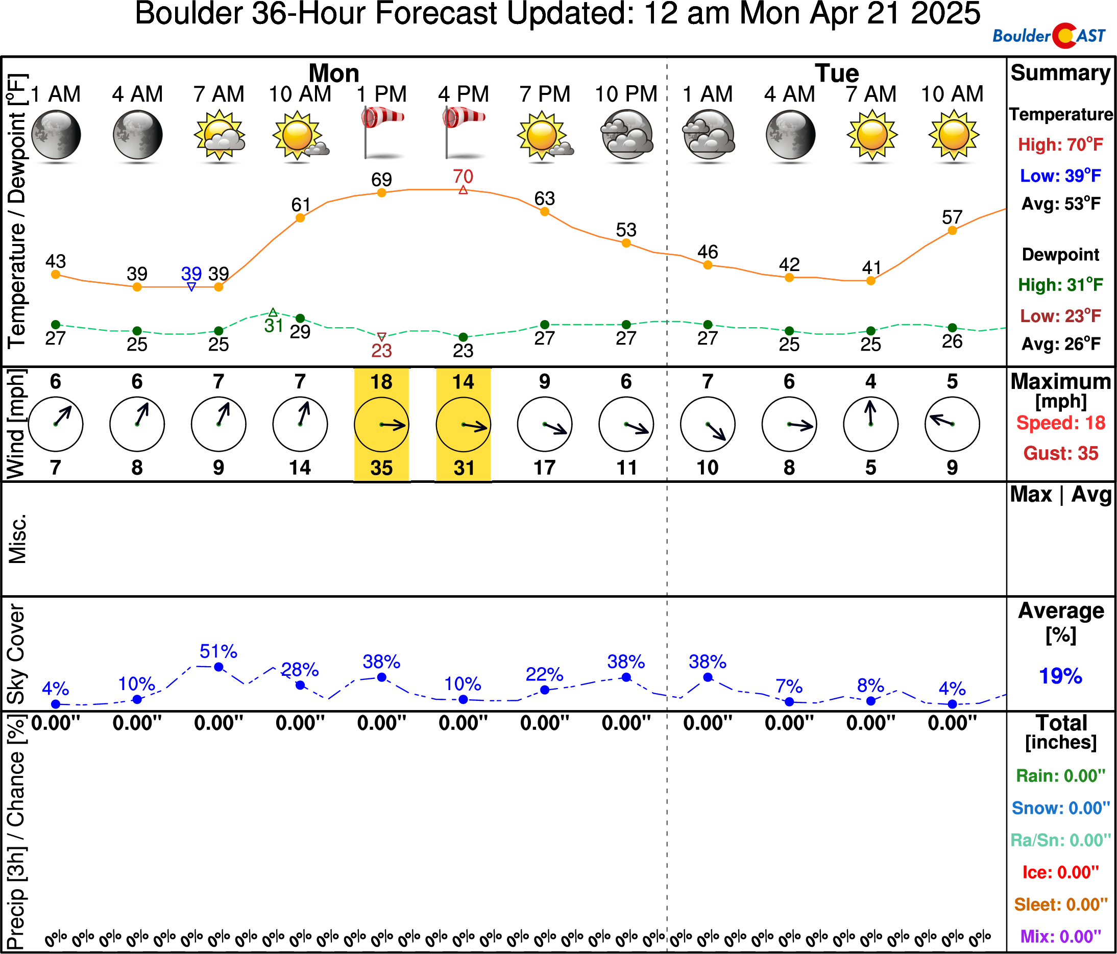
- Warm & Breezy on Monday: Gusts up to 35 MPH through the day, but warm with lots of sunshine reaching the lower 70s. Fire danger will be elevated east of Denver.
- Spotty Storms into Midweek: A few late-day showers and storms may develop, but these will be few and far between. Temperatures stay mild in the lower 70s. Some severe risk east of Denver Wednesday.
- Moisture Ramps Up Late Week: A slow pattern shift late in the week will allow for increased moisture to invade eastern Colorado setting the stage for much better coverage of late-day showers and storms Thursday and Friday.
DISCLAIMER: This weekly outlook forecast is created Monday morning and covers the entire upcoming week. Accuracy will decrease as the week progresses as this post is NOT updated. To receive daily updated forecasts from our team, among many other perks, subscribe to BoulderCAST Premium.

Go Premium, get all the perks.
Daily Forecast Updates
Get our daily forecast discussion every morning delivered to your inbox.
All Our Model Data
Access to all our Colorado-centric high-resolution weather model graphics. Seriously — every one!
Ski & Hiking Forecasts
6-day forecasts for all the Colorado ski resorts, plus more than 120 hiking trails, including every 14er.
Smoke Forecasts
Wildfire smoke concentration predictions up to 72 hours into the future.
Exclusive Content
Weekend outlooks every Thursday, bonus storm updates, historical data and much more!
No Advertisements
Enjoy ad-free viewing on the entire site.
A warm week, eventually turning wet
The warming trend will continue on Monday in the Front Range as flow aloft turns closer to westerly early in the week in response to a shortwave disturbance passing across the far northern Rockies (i.e. Montana/Wyoming). This shortwave will allow for stronger winds across the area on Monday, gusting 20 to 35 MPH from the late morning through sunset out of the west. The model animation below shows near-surface wind gusts for our Monday:
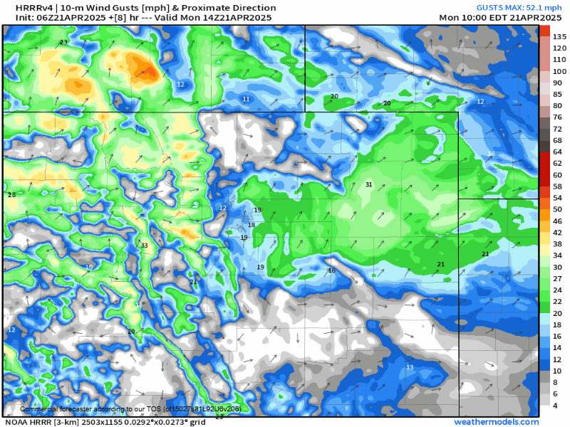
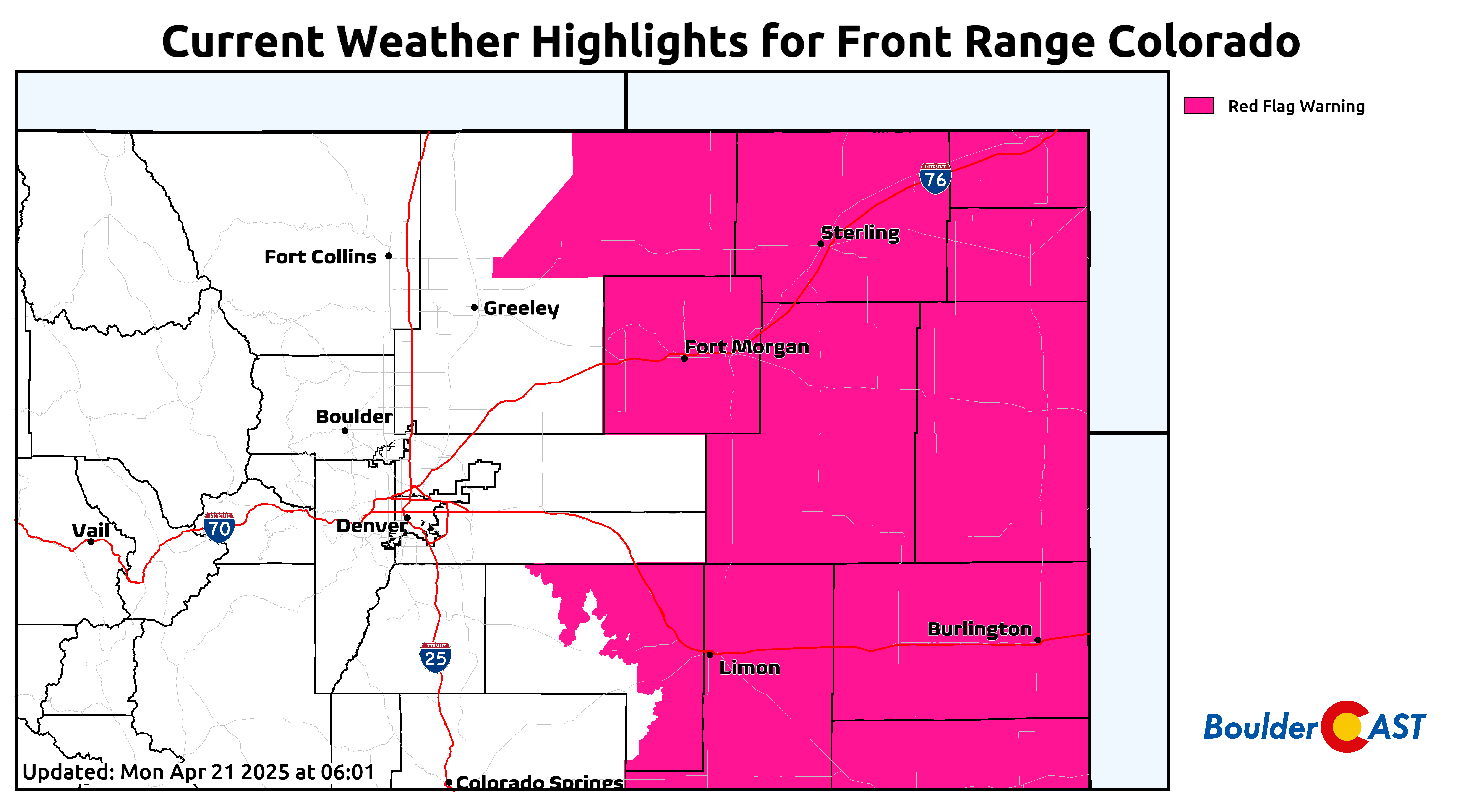
These gusty winds, combined with relative humidities below 15%, will lead to critical fire danger across portions of northeast Colorado on Monday — Red Flag Warnings are in effect out there east of Denver. Atmospheric conditions will be very similar in the Metro area today, but the recent womp of snow has moistened the vegetation enough to nullify the fire risk in our immediate area.
High temperatures will return to the lower 70s on Monday with lots of sunshine. It’s just the pesky wind that will spoil things a tad to begin the week.
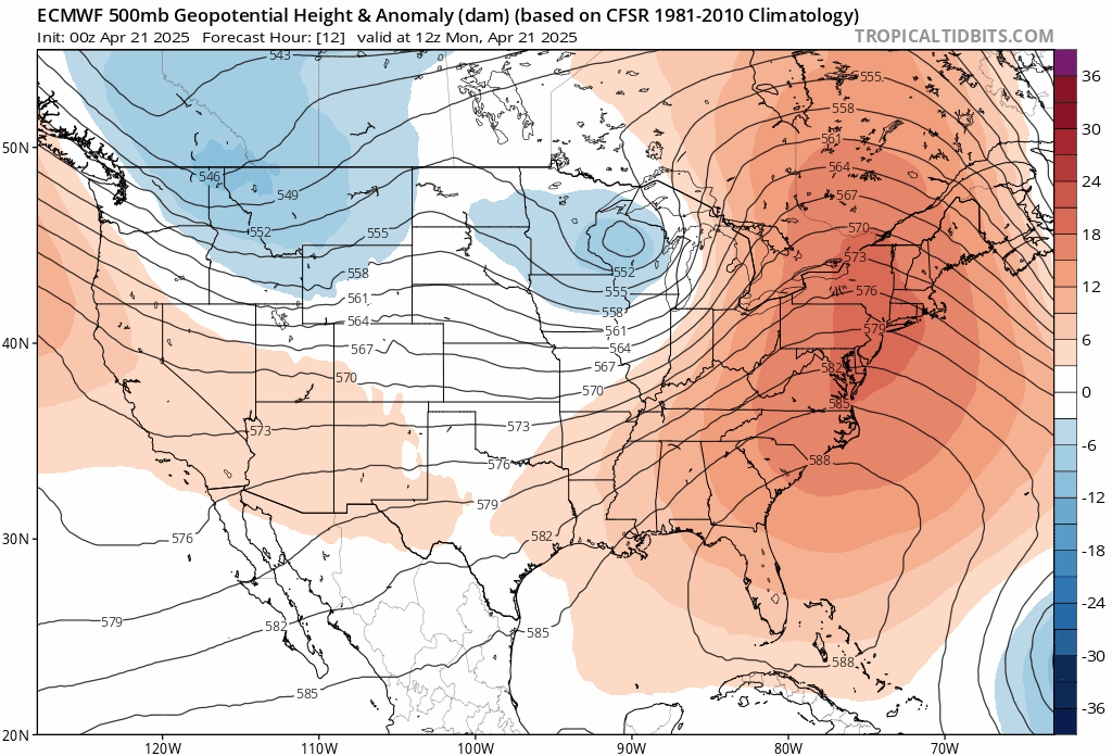
Through the rest of the week, we will see a strong ridge gradually redevelop across eastern half of the country, with Colorado on the far western fringe of this with increasing southerly flow into our area. The European model 500mb height anomaly forecast animation below shows the anticipated pattern evolution through Friday night:
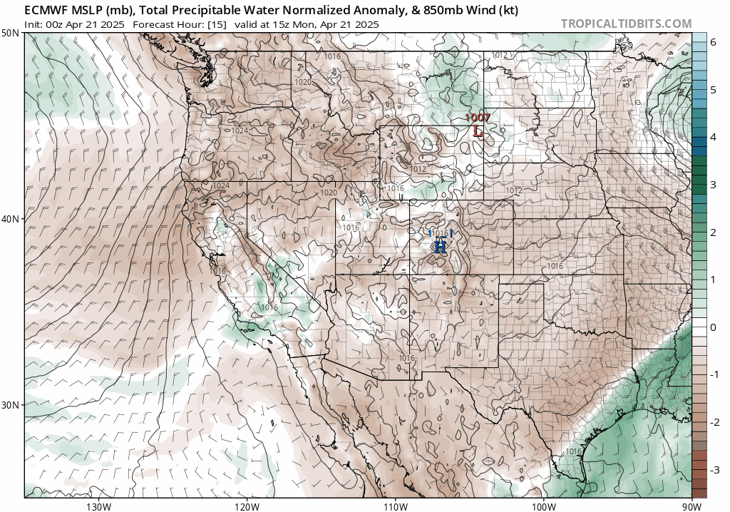
As this ridge develops, the faucet of Gulf of Mexico moisture will get turned on, flowing into eastern Colorado from the south and southeast during the mid to late week period. The precipitable water anomaly forecast animation below shows the surge headed our way. We start the week with very limited moisture, but there will be a decent influx beginning Wednesday, with that moisture largely lingering the rest of the week and perhaps into the weekend.
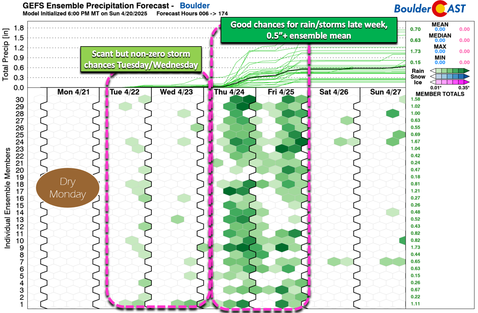
Tuesday and Wednesday will see just isolated storms with weak moisture in-place, but Thursday and Friday are shaping up to be notably wetter. It’s too early to pinpoint exact timing or strength, but there will certainly be a few weak shortwaves traversing the area later this week in the southwest flow aloft which could aid in the daily cycle of shower and storm development. The ensemble mean output for Boulder is around 0.6″ of rain through the week, mostly coming from the increased activity Thursday and Friday. This pattern is not cold enough for any snow, even in the Foothills.
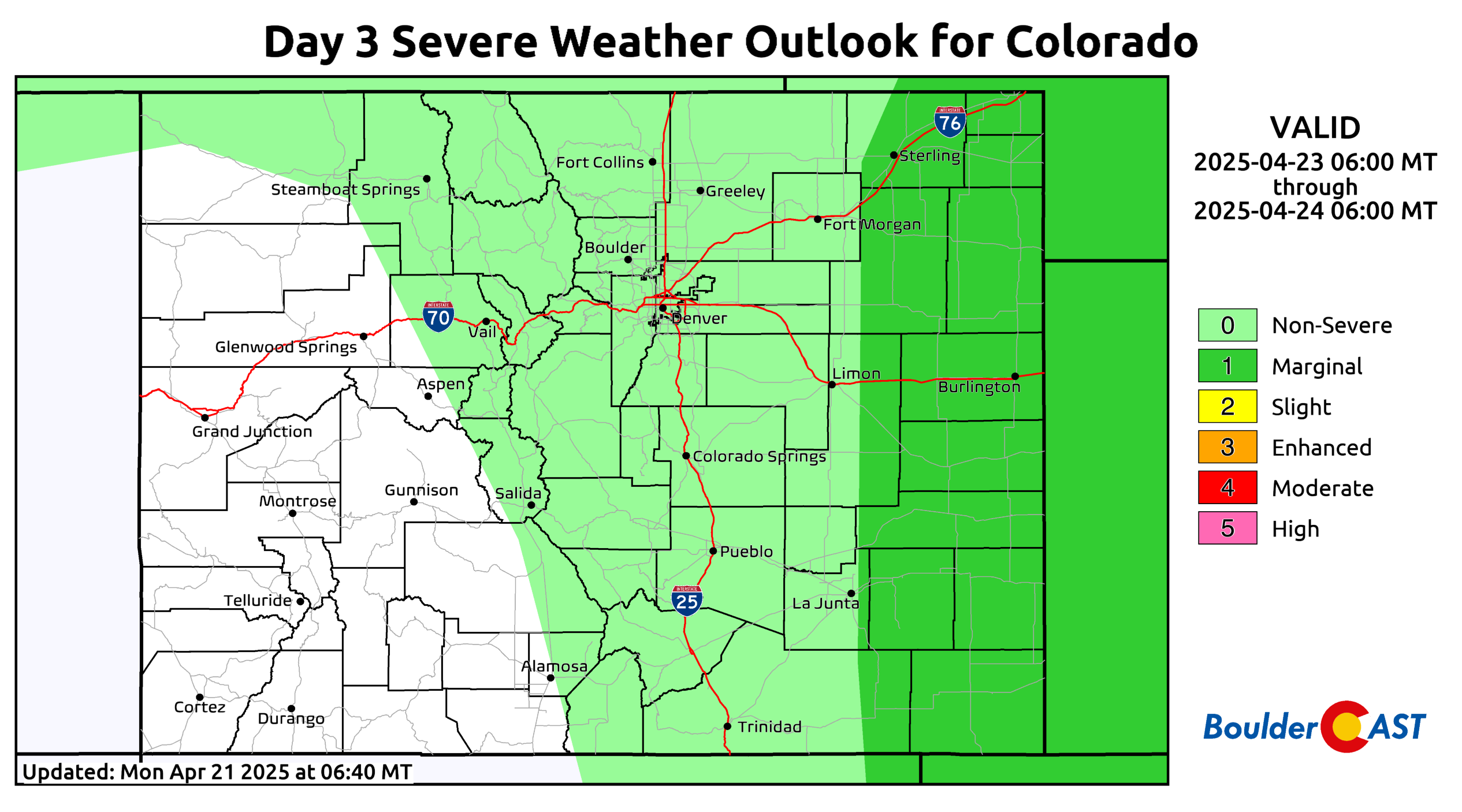
There will probably be some severe weather to worry about Wednesday and again on Thursday. At this point, it’s unlikely this risk would include the Boulder-Denver area. Instead, the better chance for severe winds and hail will be across far eastern Colorado where moisture availability will be greater. The NOAA Storm Prediction Center already highlights this area at Marginal Risk for Wednesday afternoon and evening:
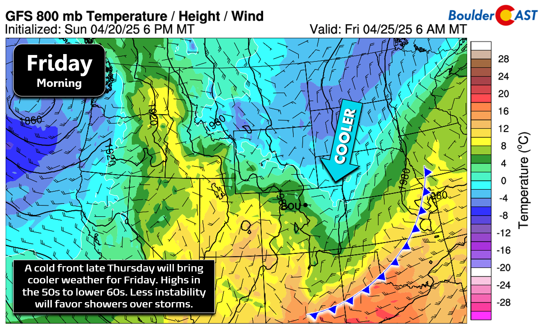
Late Thursday into Thursday night, models show a cold front dropping across eastern Colorado, though the timing is varied from run to run this far out. This front will bring cooler temperatures on Friday with more stability leading to showery conditions instead of storms to end the week. High temperatures on Friday will be in the 50s to around 60 degrees under upslope flow at the surface.
In summary, our week will start out warm in the lower 70s Monday through Wednesday, with mostly dry conditions. Thursday and Friday turn cooler and wetter! This is just another typical spring week in Colorado that will allow our vegetation to continue its annual green up — enjoy!
Forecast Specifics:
Monday: Mostly sunny, warm and breezy. Winds gusting up to 35 MPH during the day from the west. Highs top out in the lower 70s across the Plains with upper 50s in the Foothills.
Tuesday: Morning sun, then partly cloudy with a slight chance of a shower or weak thunderstorm. Highs once again in the lower 70s on the Plains with upper 50s in the Foothills.
Wednesday: Partly cloudy with a slight chance of a late day thunderstorm. Storms may be severe well east of Denver. Temperatures stay in the lower 70s on the Plains with middle 50s in the Foothills.
Thursday: Slightly cooler with an increased chance of late-day thunderstorms. Storm could produce heavy rain and small hail. Highs cooler in the middle 60s with lower 50s in the Foothills.
Friday: Even cooler behind a cold front. Mostly cloudy with some showers possible in the afternoon and evening. Highs reach near 60 degrees on the Plains with upper 40s in the Foothills.
Weekend: Staying unsettled, but not as wet as prior days. Temperatures top out in the 60s to lower 70s with slight chances for late-day showers or storms.
Get BoulderCAST updates delivered to your inbox:
DISCLAIMER: This weekly outlook forecast is created Monday morning and covers the entire upcoming week. Accuracy will decrease as the week progresses as this post is NOT updated. To receive daily updated forecasts from our team, among many other perks, subscribe to BoulderCAST Premium.
Go Premium, get all the perks.
Daily Forecast Updates
Get our daily forecast discussion every morning delivered to your inbox.
All Our Model Data
Access to all our Colorado-centric high-resolution weather model graphics. Seriously — every one!
Ski & Hiking Forecasts
6-day forecasts for all the Colorado ski resorts, plus more than 120 hiking trails, including every 14er.
Smoke Forecasts
Wildfire smoke concentration predictions up to 72 hours into the future.
Exclusive Content
Weekend outlooks every Thursday, bonus storm updates, historical data and much more!
No Advertisements
Enjoy ad-free viewing on the entire site.
Enjoy our content? Give it a share!


You must be logged in to post a comment.