

Our highly-anticipated winter storm is taking shape some 500 miles to our west Thursday morning. Change will begin across the Denver Metro area Thursday afternoon and evening with the arrival of a strong cold front. After an initial chance of isolated thunderstorms, we’ll change over to frozen precipitation fully by midnight and never look back, with light snow continuing well into Friday night. Despite lots of melting and compaction, a few to several inches of heavy wet snow are expected in Boulder and Denver, with significantly more in the nearby Foothills. We discuss the latest storm timeline, how much sloppy snow will stick, and what type of travel and vegetation impacts to expect from this late-season spring snowstorm.
Premium Storm Update (4/18/2025 8:30AM): Springtime snow is underway across the area with wet accumulations overnight up to 6 inches in the higher terrain (Estes Park) and up to 3.5 inches across the lower elevations (Boulder). We discuss the latest forecast details, including when we expect an uptick in snow coverage and intensity, how much more snow will accumulate, and when the flakes will come to an end. READ HERE
At a Glance
- One Last Warm Day: Thursday will offer up one final warm day with highs in the 70s and sunshine (initially). Get outside to enjoy it!
- Cold Front Blows In: A strong cold front will arrive late Thursday afternoon or early evening, tanking temperatures and commencing upslope across the area.
- The Change-Over: After a chance for rain/thunderstorms early, it’ll quickly get cold enough to change-over to snow around midnight Thursday night (or slightly sooner)
- Melting Will Be a Thing: Despite this event being mostly snow, the accumulation potential across the lower elevations will be lessened due to melting and compaction outpacing snowfall rates. Several inches are expected in Boulder and Denver, but much more in the higher terrain.
- Limited Travel Impacts: Warm road temperatures and the April sun will keep roadways mostly just wet during this storm, but slushy roads could develop Friday evening/night.
- Sub-Freezing Warning: Temperatures both Thursday night and Friday night are expected to drop below freezing across the entire area. Above ground pipes, like irrigation backflows, should be drained in preparation.

Go Premium, get all the perks.
Daily Forecast Updates
Get our daily forecast discussion every morning delivered to your inbox.
All Our Model Data
Access to all our Colorado-centric high-resolution weather model graphics. Seriously — every one!
Ski & Hiking Forecasts
6-day forecasts for all the Colorado ski resorts, plus more than 120 hiking trails, including every 14er.
Smoke Forecasts
Wildfire smoke concentration predictions up to 72 hours into the future.
Exclusive Content
Weekend outlooks every Thursday, bonus storm updates, historical data and much more!
No Advertisements
Enjoy ad-free viewing on the entire site.
Wet snow for everyone, but with limited travel impacts
As of early Thursday morning, everything is coming together quite well across the western United States in lead up to the anticipated spring storm headed for the Front Range to end the week. The primary storm system, the one packing the cold air and most of the energy, is currently dropping straight south through Idaho towards the Great Basin, as seen in the GOES-East water vapor animation below. A secondary storm, a broad but weak closed low pressure, is located offshore from southern California.
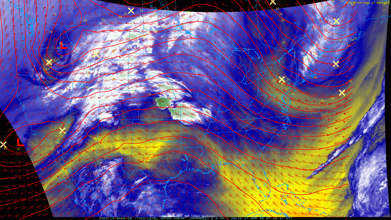
After some big differences earlier in the week, models have come into better agreement on how these two systems will interact with each other in the days ahead which has helped to curb some of the uncertainty with this event. In short, the northern storm will dig into the Four Corners area late on Friday, in the process absorbing the southern low. The combination of these two storms, separate initially but eventually merging, will bring an extended period of unsettled weather to our area beginning late in the day Thursday lasting until sometime on Saturday.
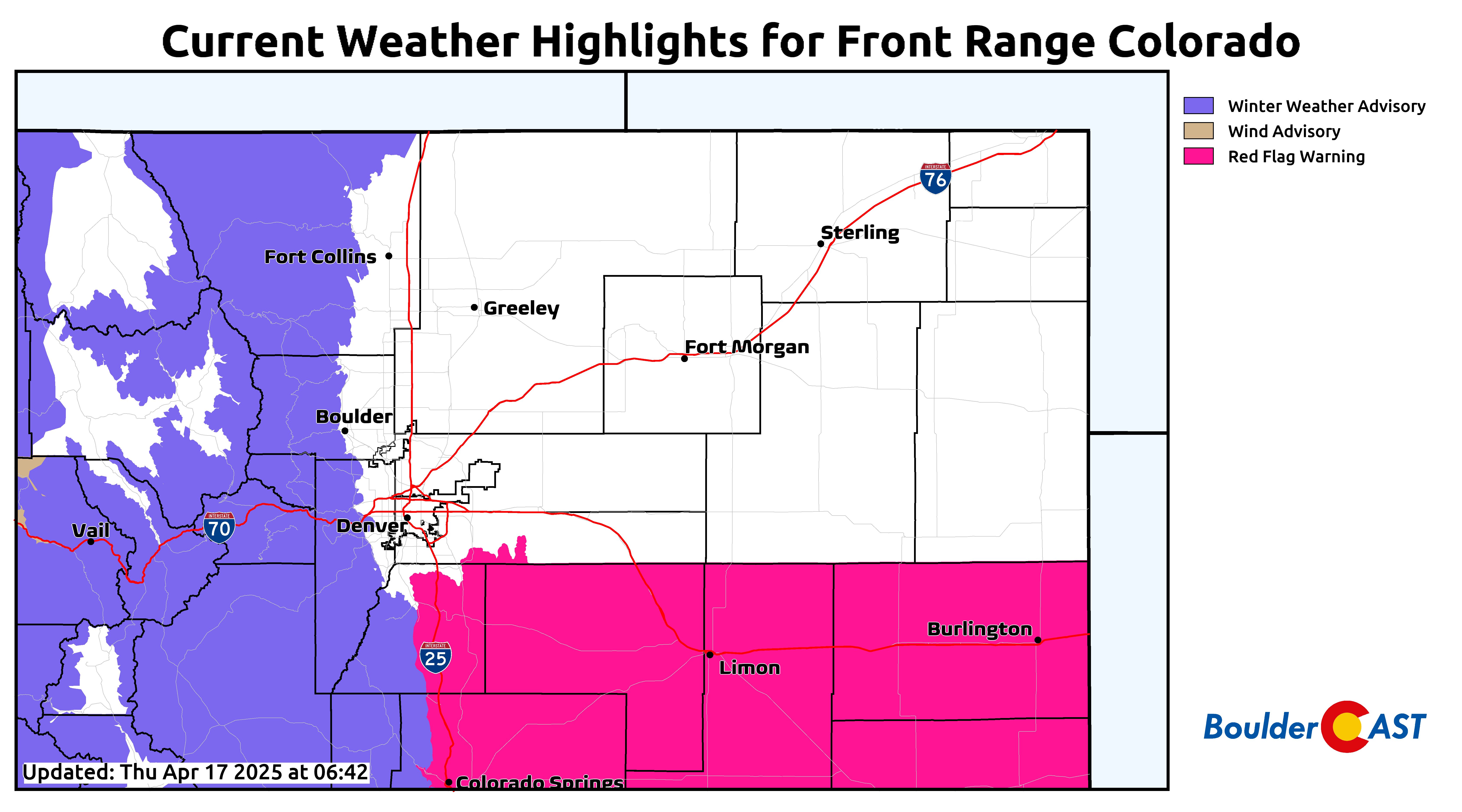
Ahead of this storm, we’ll have one more warm day on Thursday with elevated fire danger as dry southwest flow intensifies. High temperatures Thursday afternoon will range from the lower 60s (far north near Wyoming Border) to the middle 70s (from Denver southward). These southern areas will be warmest and windiest and thus have increased fire danger. Red Flag Warnings are in effect south of Denver across the Palmer Divide and all of southeast Colorado. Boulder and Denver are not included, but there’s still some fire risk here as well. It just won’t be as intense or long-lasting as areas to the south.
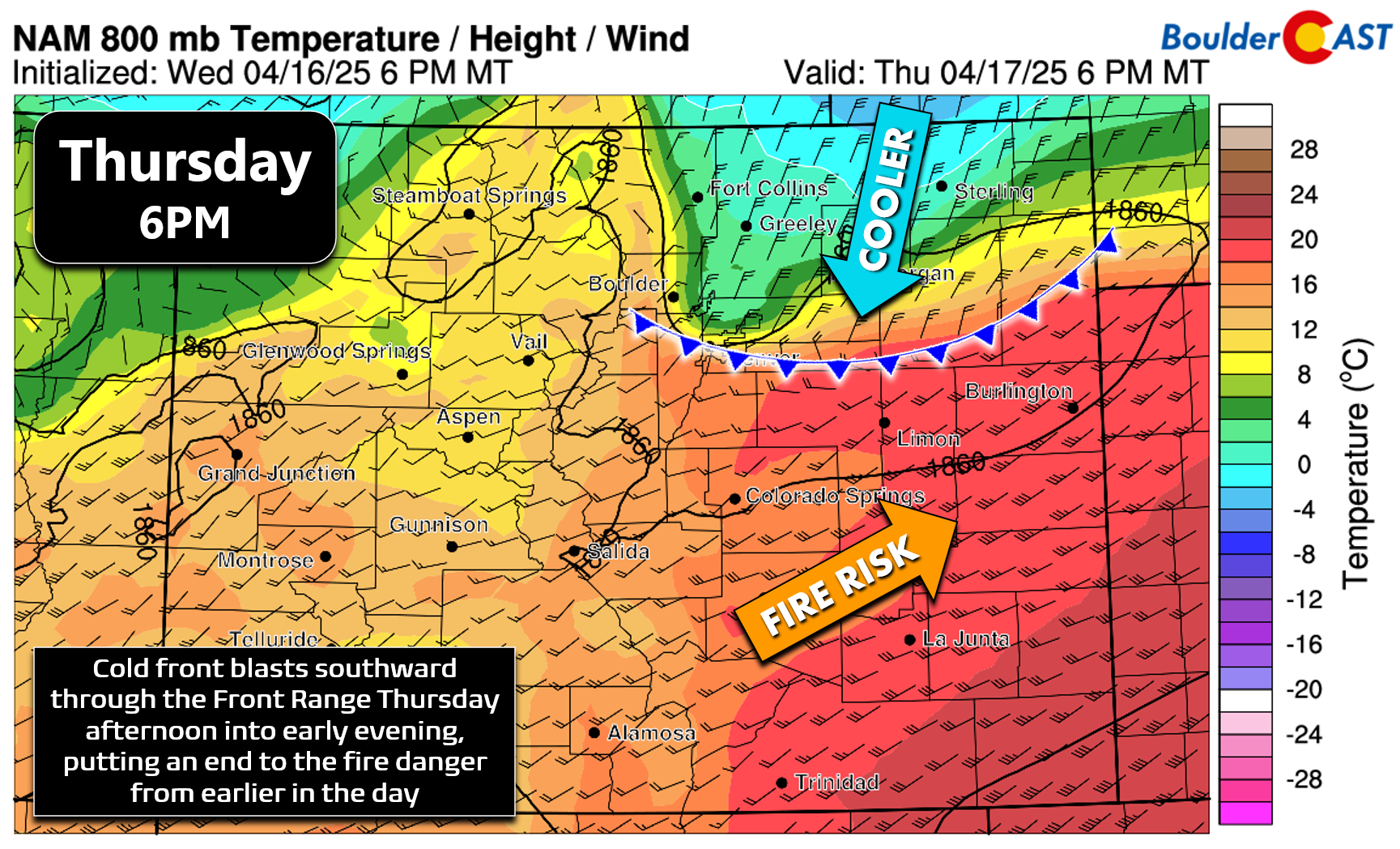
This fire danger will be eradicated quickly as the primary cold front blasts through our area late Thursday afternoon into early evening. The timing of these stronger fronts is always a bit tricky. Models mostly put it through Denver around 4 to 5PM, but it wouldn’t be surprising if it came in an hour or two earlier, as usual. Wind gusts of 20 to 40 MPH will accompany and immediately follow the cold front out of the north-northeast, with temperatures dropping some 20 to 30 degrees rather quickly. We’ll tumble from the 60s or 70s into the 30s within an hour or two, eventually dropping into the 20s later Thursday night.
Our NowCAST forecast below for Boulder shows plenty of sunshine today with temperatures in the 70-degree range. The morning and early afternoon period will be the last of the nice weather for the time being. Try to get outside and enjoy it if you can — but please no sparks or flames!
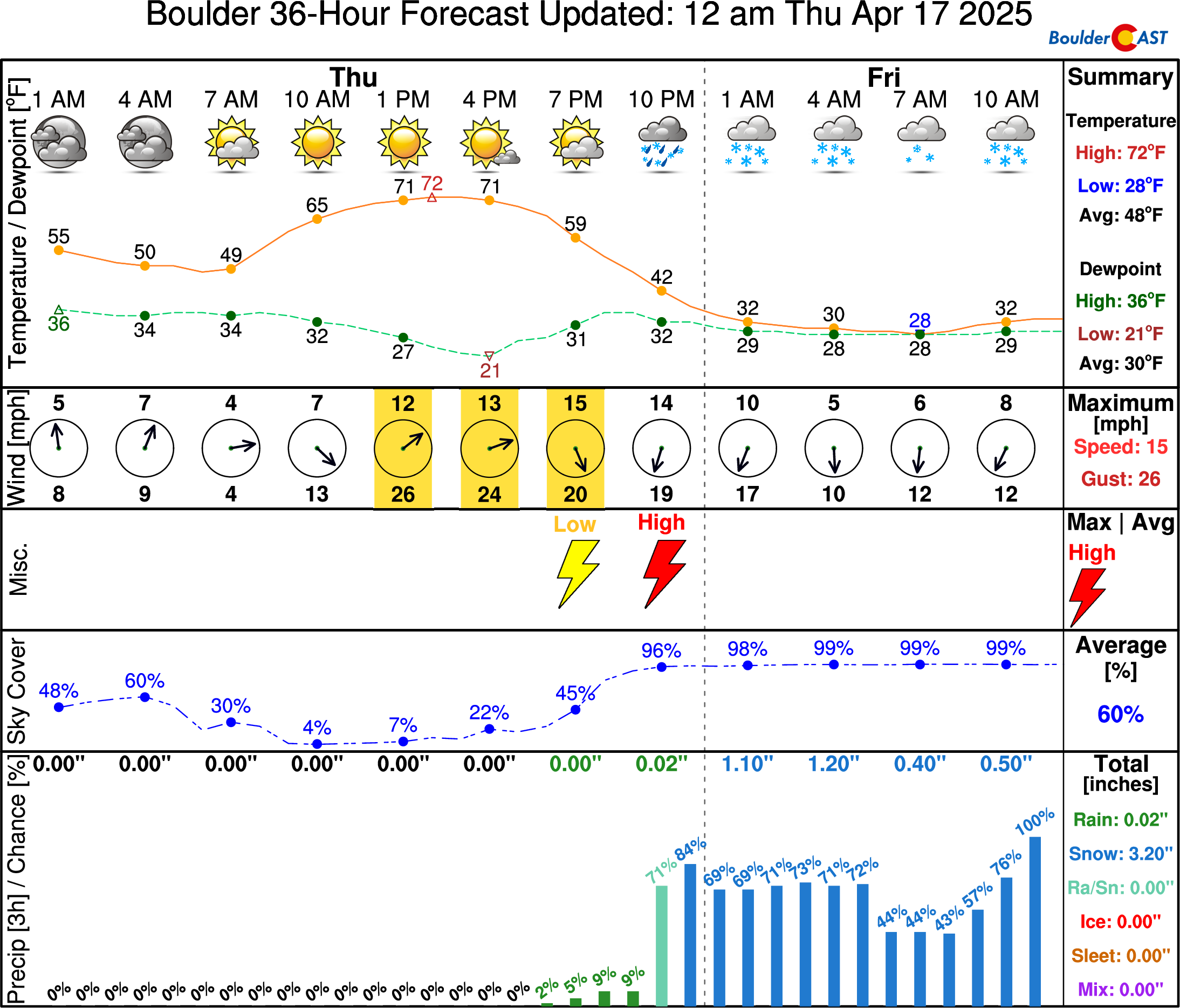
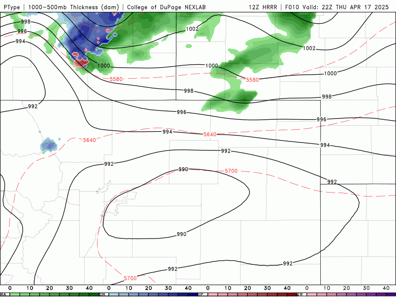
Precipitation will be delayed following the cold front, with spotty rain showers expected to slowly develop through the evening hours in time, with a chance for some thunder mixed in as well — it wouldn’t be a true Colorado spring storm without both thunder and snow, would it?! As temperatures plummet towards and below freezing late Thursday evening, a change-over to snow will occur for the entire area — this shift appears to happen around midnight or so, perhaps a bit sooner depending on precipitation coverage and intensity late this evening. The HRRR model simulated radar animation below shows how the precipitation may evolve Thursday night through Friday night.
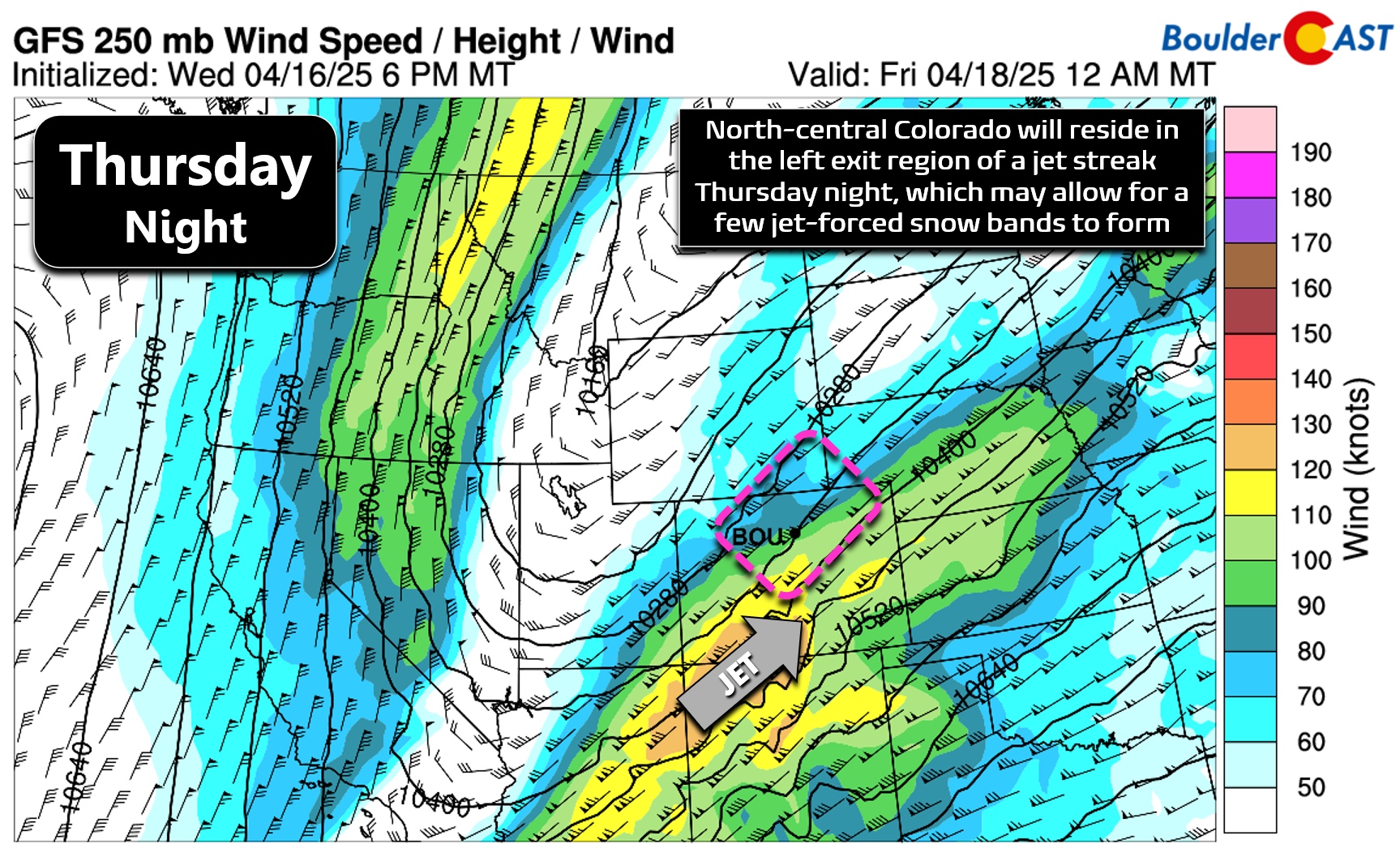
This short-range model is indicating some potential for banded snow Thursday night across the northern Front Range, which is undoubtedly tied to a jet streak phasing across the southern Rockies. North-central Colorado will reside in the left exit region of this jet overnight for a period of time, which may allow for a band of more intense snowfall to develop somewhere across the area. The short-range guidance favors the area northwest of Boulder, including around Estes Park, but it’s hard to say if this will actually verify.
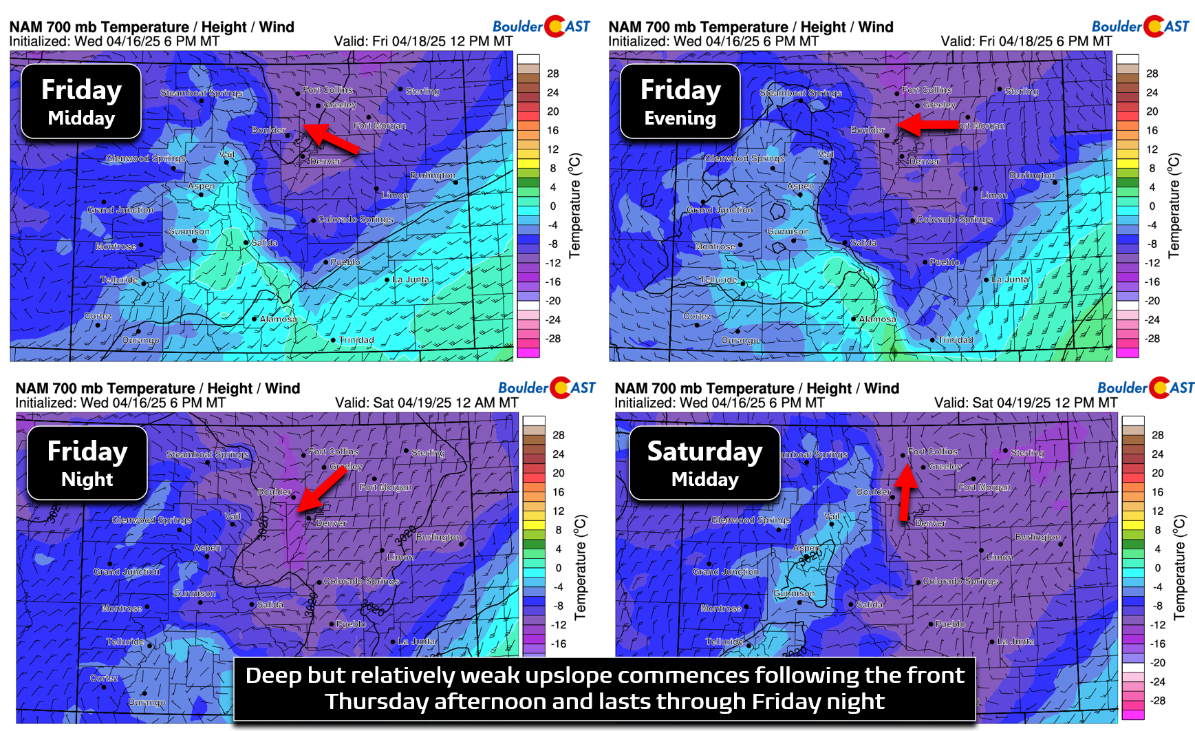
Outside of the jet, there’s not a lot of forcing around until later Friday morning when upslope turns almost due easterly and better large-scale lift enters the region as the primary storm moves towards the Four Corners. Thus, outside of a few jet-bands and the early convection, we may see a break in the action with just drizzle or freezing drizzle late Thursday night into Friday morning. Upslope flow will remain locked in east of the Continental Divide through all of Friday and Friday night. Most models show upslope ending sometime Saturday morning which will help to dry us out and bring an end to most of the precipitation then. The red arrows below show the upslope directionality at ~10,000 feet elevation overhead at various points of the storm.
With this, we should see light to moderate snow develop early Friday again and linger all the way into Saturday morning, upwards of 24 straight hours. Temperatures will remain cold enough to keep precipitation entirely in the form of snow, even across the lower elevations during the daytime Friday. However, this time of year, accumulation can be difficult to gauge due to warm ground and ambient air temperatures, as well as the strong mid-April sun — all of which will contribute to melting. This time of year we typically need three things to happen to get significant snow accumulation across the Boulder-Denver area:
- Prolonged moderate to heavy snowfall, such that snowfall rates greatly outpace the rate of melting
- Very cold air, such that ground temperatures can be forced down towards the freezing mark
- The snowfall to occur at night, or at least well away from local solar noon when the sun is lower in the sky
Broadly speaking, this event will not meet those first two criteria very well. Yes, it will be cold enough for almost this entire storm to unfold as snow, but there’s not exceptional cold here — ground temperatures, and especially road temperatures, will remain mostly above freezing. Second, the storm track isn’t that great for us, with the parent low remaining too far away most of the time to provide substantial lift to support heavier snowfall rates. This will mostly be a long duration event with snowfall rates on the lighter end of the spectrum. Thus, the key factor playing into how much accumulation we’ll see across the lower elevations from this storm is timing — how much of the snow will fall during the nighttime periods and during times with lower sun angle?
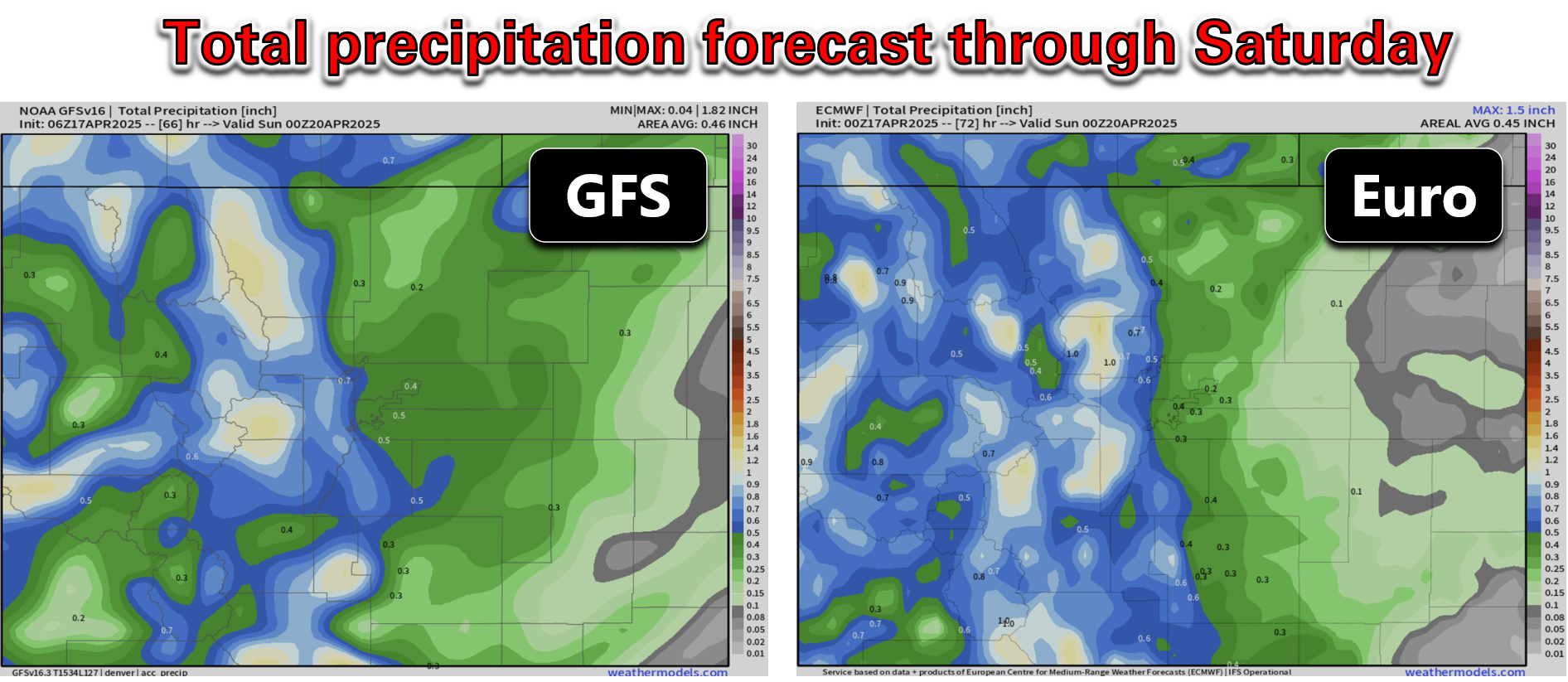
In terms of moisture, there’s pretty good overall agreement on just how much we’ll see from this storm. The GFS (left) and Euro (right) model forecasted precipitation totals are shown below for northeast Colorado. In general, we’re expecting around 1″ of moisture in and near the Foothills, with lesser amounts of 0.25 to 0.75″ for areas away from the terrain.
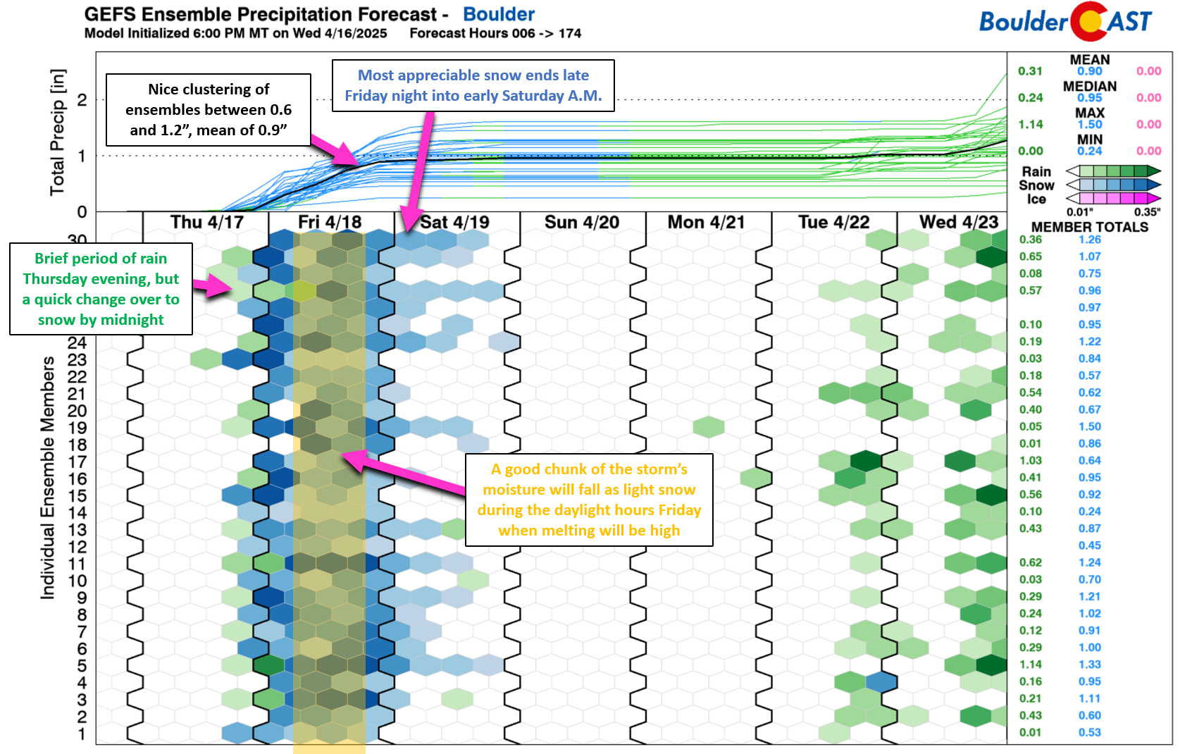
The ensembles also show fairly good consistency between member runs. Boulder is well-clustered between 0.6 and 1.2″, with a mean output of 0.9″. Definitely a sizable storm for us, but nothing that crazy. We also see below that a good chunk of the storm’s output will occur during the daylight hours Friday when melting will be highest thanks to the April sun.
Thus, our going snowfall forecast at this point will see some minor accumulations Thursday night after rain changes over to snow while the sun is down. Across the lower elevations, a coating to 3 inches is possible by sunrise Friday, with 1 to 4 inches in the Foothills (up to 6 inches if one of those jet-forced snow bands hits hard). Snow will continue to fall through the day Friday, but with melting largely outpacing snowfall rates, at least until the late-day period. We may see an additional inch or three during the day accumulate on the grass or elevated surfaces, but no travel impacts are expected below 6500 feet with plentiful melting. As the sun lowers in the sky Friday evening and sets, accumulation should pick back up again with snowflakes continuing into the overnight. This Friday evening and night period is currently when we expect most of the snow for the lower elevations, with another 1 to 5 inches possible across the area by Saturday morning, highest west and somewhat dependent on whether we can get some pockets of moderate snow going or not. Some slush may develop on the roadways, but travel isn’t expected to be substantially impacted in the Metro area. The Foothills and Mountains will certainly see snow-packed roads at times, so do plan on winter driving conditions up there.
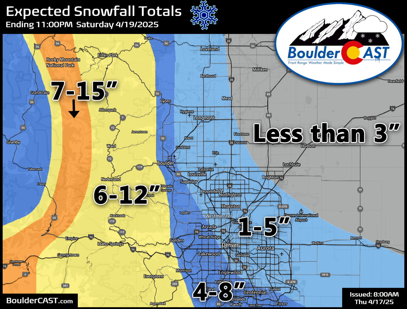
Our snowfall forecast map for this late-season wet snow event is shown below, covering all snow falling from Thursday evening through Saturday. The greatest totals will be in the higher terrain where temperatures will be colder, up to 12 inches in the higher Foothills, and up to 15 inches near treeline along the eastern slopes of the Continental Divide. Across the lower elevations, snow amounts will be more varied due to melting. Our forecast calls for 4 to 8 inches in Boulder and the far western suburbs of Denver, with 1 to 5 inches elsewhere to the east. Keep in mind there will be a ton of melting, so you may never actually see these forecast totals piled up on the ground at any one time.
Though snow totals aren’t expected to be huge, this will be a wet spring snow, with potential impacts to power lines and leafed-out trees and plants. We won’t see major issues from 3″ or less, but any locations that get 5″+ could contend with downed tree branches and spotty power outages. This is most likely to occur from Boulder to Golden to Littleton.
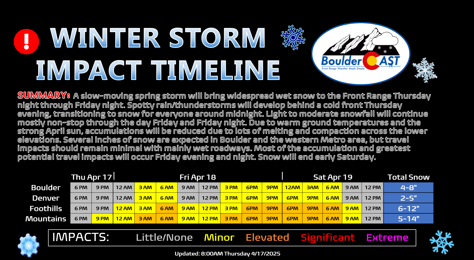
Our storm impact timeline shows the period when travel disruption may occur. There could be impacts Thursday night into Friday morning in the higher terrain. Melting during the day will limit travel impacts, before conditions worsen again Friday evening and night up there. The greatest potential for slushy roads in Boulder and Denver comes Friday evening and night. One final word of caution: temperatures both Thursday night and Friday night are expected to drop well below freezing across the entire area (mid to upper 20s). Above ground pipes, like irrigation backflows, should definitely be drained in preparation. Sub-surface irrigation lines and sprinkler heads will be totally fine. You have been warned!
Finally, here’s a quick rundown of the storm headed our way:
- Thursday: Warm & a bit breezy with highs in the lower 70s. A cold front arrives late afternoon or so, dropping temperatures and with winds blustery from the northeast.
- Thursday night: Spotty rain showers with some thunder develop by the late evening, changing to snow around midnight or sooner. Light snow may mix with freezing drizzle overnight into Friday morning. Accumulations of a coating to 3 inches are possible across the lower elevations.
- Friday: Light to moderate snow continues through the entire day, but with limited accumulation due to melting. Perhaps 1 to 3 inches may stick on the grassy surfaces, but roads remain just wet. High temperatures the middle 30s — brr!
- Friday night: As the sun lowers and sets, accumulation potential will increase with minimal melting overnight. Depending on how long the snow persists into the night and the intensity, additional accumulations of 1 to 5 inches are expected, highest west and southwest of Denver.
- Saturday: Snow ends in the morning but the day remains cold and gloomy. Temperatures top out from 40 to 45 degrees.
Whew, that was quite the forecast discussion today. Spring snowstorms are always super messy and required added attention to the details. However, that’s all we have for now. Come find us on Twitter, Bluesky, Facebook, and Threads for impromptu weather updates as this spring snowstorm unfolds, or subscribe to get notified of our long-form updates here. We’ll be back Friday morning with a Premium Storm Update to discuss any notable forecast shifts for the back half of the storm. Otherwise, we hope you have a great sloppy and snowy lead up to the weekend!
Get BoulderCAST updates delivered to your inbox:
Go Premium, get all the perks.
Daily Forecast Updates
Get our daily forecast discussion every morning delivered to your inbox.
All Our Model Data
Access to all our Colorado-centric high-resolution weather model graphics. Seriously — every one!
Ski & Hiking Forecasts
6-day forecasts for all the Colorado ski resorts, plus more than 120 hiking trails, including every 14er.
Smoke Forecasts
Wildfire smoke concentration predictions up to 72 hours into the future.
Exclusive Content
Weekend outlooks every Thursday, bonus storm updates, historical data and much more!
No Advertisements
Enjoy ad-free viewing on the entire site.
Enjoy our content? Give it a share:


You must be logged in to post a comment.